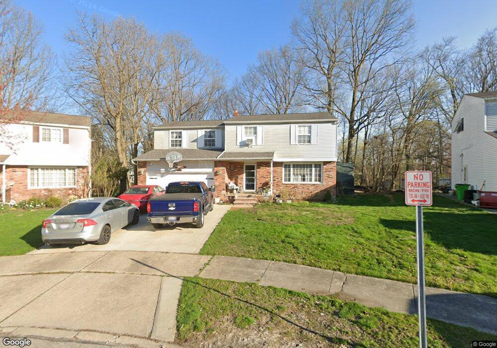
137 Noran Cir Bedford, OH 44146
Estimated Value: $226,000 - $278,000
5
Beds
3
Baths
2,319
Sq Ft
$107/Sq Ft
Est. Value
About This Home
This home is located at 137 Noran Cir, Bedford, OH 44146 and is currently estimated at $248,235, approximately $107 per square foot. 137 Noran Cir is a home located in Cuyahoga County with nearby schools including Heskett Middle School, Bedford High School, and Ohio College Preparatory School.
Ownership History
Date
Name
Owned For
Owner Type
Purchase Details
Closed on
Sep 7, 1994
Sold by
Diersen John T
Bought by
Howard Dennis C and Howard Deborah L
Current Estimated Value
Home Financials for this Owner
Home Financials are based on the most recent Mortgage that was taken out on this home.
Original Mortgage
$114,000
Interest Rate
8.65%
Mortgage Type
New Conventional
Purchase Details
Closed on
Feb 28, 1983
Sold by
Diersen John T and Diersen Lois A
Bought by
Diersen John T
Purchase Details
Closed on
Jan 1, 1975
Bought by
Diersen John T and Diersen Lois A
Create a Home Valuation Report for This Property
The Home Valuation Report is an in-depth analysis detailing your home's value as well as a comparison with similar homes in the area
Home Values in the Area
Average Home Value in this Area
Purchase History
| Date | Buyer | Sale Price | Title Company |
|---|---|---|---|
| Howard Dennis C | $122,000 | -- | |
| Diersen John T | -- | -- | |
| Diersen John T | -- | -- |
Source: Public Records
Mortgage History
| Date | Status | Borrower | Loan Amount |
|---|---|---|---|
| Closed | Howard Dennis C | $114,000 |
Source: Public Records
Tax History Compared to Growth
Tax History
| Year | Tax Paid | Tax Assessment Tax Assessment Total Assessment is a certain percentage of the fair market value that is determined by local assessors to be the total taxable value of land and additions on the property. | Land | Improvement |
|---|---|---|---|---|
| 2024 | $6,075 | $81,200 | $11,515 | $69,685 |
| 2023 | $4,543 | $51,740 | $10,330 | $41,410 |
| 2022 | $4,007 | $51,730 | $10,325 | $41,405 |
| 2021 | $3,912 | $51,730 | $10,330 | $41,410 |
| 2020 | $3,670 | $43,470 | $8,680 | $34,790 |
| 2019 | $3,574 | $124,200 | $24,800 | $99,400 |
| 2018 | $3,556 | $43,470 | $8,680 | $34,790 |
| 2017 | $3,597 | $41,620 | $6,690 | $34,930 |
| 2016 | $3,566 | $41,620 | $6,690 | $34,930 |
| 2015 | $3,670 | $41,620 | $6,690 | $34,930 |
| 2014 | $3,670 | $45,220 | $7,280 | $37,940 |
Source: Public Records
Map
Nearby Homes
- 95 Noran Cir
- 78 Gould Ave
- 32 Ellenwood Ave
- 377 Hubbell Cir
- 0 Hubbell Cir
- 54 Hubbell Way
- 66 Hubbell Way
- 58 Hubbell Way
- 62 Hubbell Way
- 46 Thames Ave
- 54 Willard Ave
- 62 Willard Ave
- 57 Hubbell Way
- 61 Hubbell Way
- 443 Broadway Ave
- 475 Lamson Ave
- 5571 Oakwood Ave
- 59 Greencroft Rd
- 20620 Donny Brook Rd
- 144 Maria Dr Unit 15B
- 143 Noran Cir
- 131 Noran Cir
- 188 Grand Blvd
- 182 Grand Blvd
- 125 Noran Cir
- 146 Noran Cir
- 114 Southwick Dr
- 202 Grand Blvd
- 118 Southwick Dr
- 140 Noran Cir
- 110 Southwick Dr
- 176 Grand Blvd
- 119 Noran Cir
- 106 Southwick Dr
- 132 Noran Cir
- 206 Grand Blvd
- 102 Southwick Dr
- 113 Noran Cir
- 126 Noran Cir
- 124 Southwick Dr