Estimated Value: $241,908 - $258,000
3
Beds
1
Bath
1,412
Sq Ft
$177/Sq Ft
Est. Value
About This Home
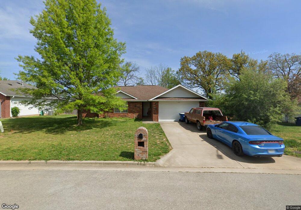
This home is located at 137 W Trail Point Dr, Nixa, MO 65714 and is currently estimated at $249,727, approximately $176 per square foot. 137 W Trail Point Dr is a home with nearby schools including Century Elementary School, Summit Intermediate School, and Nixa Junior High School.
Ownership History
Date
Name
Owned For
Owner Type
Purchase Details
Closed on
Mar 7, 2022
Sold by
Flintrock Resid Holdings Llc
Bought by
Kjj Properties Llc
Current Estimated Value
Purchase Details
Closed on
Mar 21, 2005
Sold by
Montileone Development Company Inc
Bought by
Wicklund Corey G and Wicklund Alyssa D
Home Financials for this Owner
Home Financials are based on the most recent Mortgage that was taken out on this home.
Original Mortgage
$100,400
Interest Rate
5.71%
Mortgage Type
New Conventional
Create a Home Valuation Report for This Property
The Home Valuation Report is an in-depth analysis detailing your home's value as well as a comparison with similar homes in the area
Home Values in the Area
Average Home Value in this Area
Purchase History
| Date | Buyer | Sale Price | Title Company |
|---|---|---|---|
| Kjj Properties Llc | -- | Titan Title | |
| Kjj Properties Llc | -- | Titan Title | |
| Wicklund Corey G | -- | None Available |
Source: Public Records
Mortgage History
| Date | Status | Borrower | Loan Amount |
|---|---|---|---|
| Previous Owner | Wicklund Corey G | $100,400 |
Source: Public Records
Tax History
| Year | Tax Paid | Tax Assessment Tax Assessment Total Assessment is a certain percentage of the fair market value that is determined by local assessors to be the total taxable value of land and additions on the property. | Land | Improvement |
|---|---|---|---|---|
| 2025 | $1,446 | $24,530 | -- | -- |
| 2024 | $1,446 | $23,200 | -- | -- |
| 2023 | $1,446 | $23,200 | -- | -- |
| 2022 | $1,329 | $21,300 | $0 | $0 |
| 2021 | $1,330 | $21,300 | $0 | $0 |
| 2020 | $1,202 | $18,370 | $0 | $0 |
| 2019 | $1,202 | $18,370 | $0 | $0 |
| 2018 | $1,119 | $18,370 | $0 | $0 |
| 2017 | $1,119 | $18,370 | $0 | $0 |
| 2016 | $1,102 | $18,370 | $0 | $0 |
| 2015 | $1,104 | $18,370 | $18,370 | $0 |
| 2014 | $1,074 | $18,320 | $0 | $0 |
| 2013 | $11 | $18,320 | $0 | $0 |
| 2011 | $11 | $37,240 | $0 | $0 |
Source: Public Records
Map
Nearby Homes
- 117 W Trail Point Dr
- 821 S Barberry Ct
- 104 Willow Ln
- 000 Croley Blvd Unit Lots 12,13, 14
- 427 S Main St
- 425 S Devonshire St
- Sw Corner Highway 160 & St S
- 512 Baldknobber St
- 209 Shady Acres Cir
- 788 S Hackberry Ave
- 649 W Arbor Glenn Dr
- 1280 W Butterfield Dr
- 000 Citydel Rd W
- 867 S Irontree Ct
- 111 Daleview Cir
- 916 S Pindall Ln
- 000 West St
- 316 S Market St
- 403 S Bryant St
- 955 S Silverwood Ln
- 139 W Trail Point Dr
- 135 W Trail Point Dr
- 673 S Southgate St
- 141 W Trail Point Dr
- 136 W Trail Point Dr
- 138 W Trail Point Dr
- 669 S Southgate St
- 134 W Trail Point Dr
- 143 W Trail Point Dr
- 131 W Trail Point Dr
- 668 S Southgate Dr
- 809 Southgate Dr
- 142 W Trail Point Dr
- 672 S Southgate St
- 129 W Trail Point Dr
- 661 S Southgate St
- 660 S Southgate Dr
- 660 S Southgate Dr
- 128 W Trail Point Dr
- 811 S Southgate Dr
Your Personal Tour Guide
Ask me questions while you tour the home.