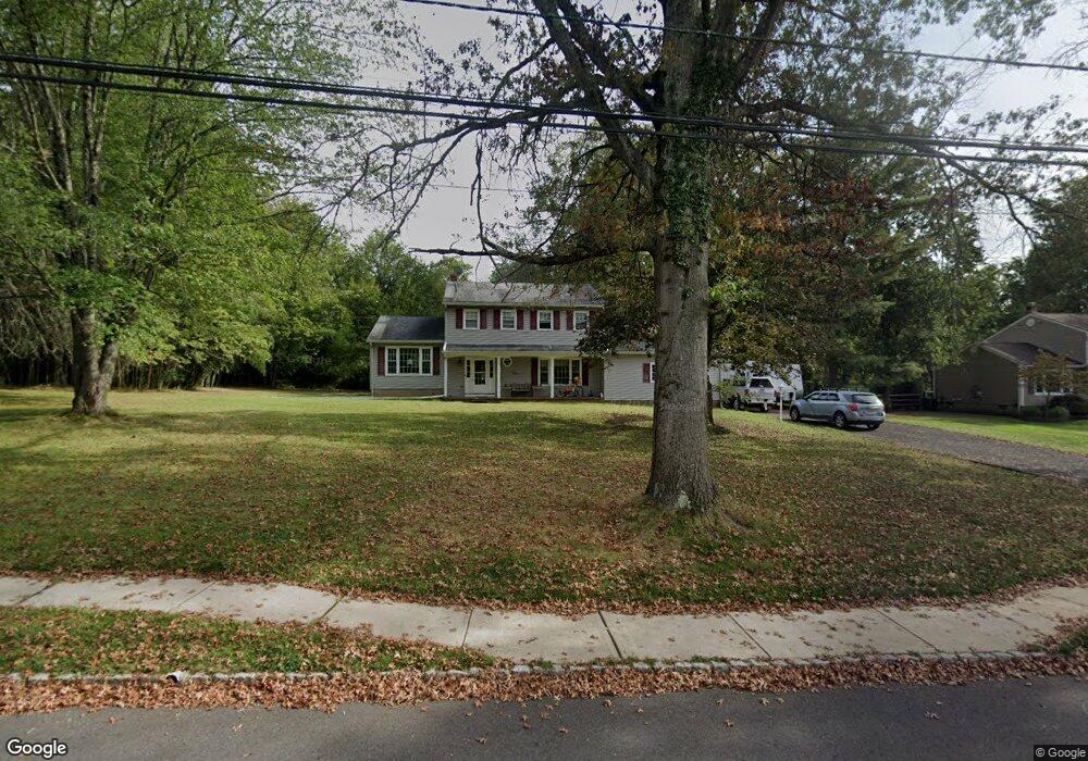
1370 Mallard Dr Martinsville, NJ 08836
Estimated Value: $726,267 - $905,000
--
Bed
--
Bath
2,044
Sq Ft
$409/Sq Ft
Est. Value
About This Home
This home is located at 1370 Mallard Dr, Martinsville, NJ 08836 and is currently estimated at $836,567, approximately $409 per square foot. 1370 Mallard Dr is a home located in Somerset County with nearby schools including Crim Primary School, Bridgewater-Raritan Middle School, and Hillside Intermediate School.
Ownership History
Date
Name
Owned For
Owner Type
Purchase Details
Closed on
Mar 12, 2019
Sold by
Roth Wayne T
Bought by
Roth Wayne T and Roth Michelle A
Current Estimated Value
Purchase Details
Closed on
Dec 18, 1998
Sold by
Hreking M Carter
Bought by
Roth Wayne and Roth Michelle
Purchase Details
Closed on
Aug 31, 1995
Sold by
Mohr Richard
Bought by
Berking Carter Sands and Berking Adele Sands
Home Financials for this Owner
Home Financials are based on the most recent Mortgage that was taken out on this home.
Original Mortgage
$215,000
Interest Rate
7.8%
Create a Home Valuation Report for This Property
The Home Valuation Report is an in-depth analysis detailing your home's value as well as a comparison with similar homes in the area
Home Values in the Area
Average Home Value in this Area
Purchase History
| Date | Buyer | Sale Price | Title Company |
|---|---|---|---|
| Roth Wayne T | -- | None Available | |
| Roth Wayne | $292,000 | -- | |
| Berking Carter Sands | $269,000 | -- |
Source: Public Records
Mortgage History
| Date | Status | Borrower | Loan Amount |
|---|---|---|---|
| Previous Owner | Berking Carter Sands | $215,000 |
Source: Public Records
Tax History Compared to Growth
Tax History
| Year | Tax Paid | Tax Assessment Tax Assessment Total Assessment is a certain percentage of the fair market value that is determined by local assessors to be the total taxable value of land and additions on the property. | Land | Improvement |
|---|---|---|---|---|
| 2025 | $10,813 | $582,900 | $335,200 | $247,700 |
| 2024 | $10,813 | $555,100 | $335,200 | $219,900 |
| 2023 | $10,237 | $516,000 | $335,200 | $180,800 |
| 2022 | $10,023 | $486,100 | $330,200 | $155,900 |
| 2021 | $9,861 | $476,500 | $330,200 | $146,300 |
| 2020 | $9,827 | $467,300 | $330,200 | $137,100 |
| 2019 | $9,861 | $464,500 | $330,200 | $134,300 |
| 2018 | $9,779 | $461,700 | $330,200 | $131,500 |
| 2017 | $9,604 | $453,000 | $330,200 | $122,800 |
| 2016 | $9,448 | $452,500 | $330,200 | $122,300 |
| 2015 | $9,433 | $452,000 | $330,200 | $121,800 |
| 2014 | $9,341 | $440,800 | $330,200 | $110,600 |
Source: Public Records
Map
Nearby Homes
- 1831 Washington Valley Rd
- 1869 Washington Valley Rd
- 10 Assante Ln
- 1899 Washington Valley Rd
- 7 Meyers Way
- 1825 Kennesaw Way
- 61 Christy Dr
- 57 Christy Dr
- 1930 Mountain Top Rd
- 112 Loft Dr Unit II112
- 6 Mount Horeb Rd
- 6 Hardwood Ct
- 1600 Mountain Top Rd
- 2044 Washington Valley Rd
- 114 Branch Rd
- 499 Foothill Rd
- 2105 Washington Valley Rd
- 2111 Washington Valley Rd
- 5 2nd St
- 1266 Mount Vernon Rd
- 1362 Mallard Dr
- 1374 Mallard Dr
- 1367 Mallard Dr
- 1371 Mallard Dr
- 1358 Mallard Dr
- 1375 Mallard Dr
- 1359 Mallard Dr
- 969 Spring Run Ln
- 1381 Mallard Dr
- 1354 Mallard Dr
- 975 Spring Run Ln
- 963 Spring Run Ln
- 1351 Mallard Dr
- 1386 Mallard Dr
- 957 Spring Run Ln
- 983 Spring Run Ln
- 1387 Mallard Dr
- 1350 Mallard Dr
- 951 Spring Run Ln
- 1343 Mallard Dr