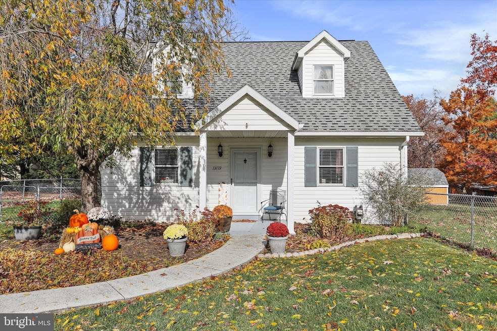

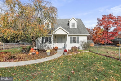
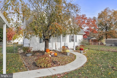


13719 Brant Rd SW Cumberland, MD 21502
Estimated payment $1,278/month
Highlights
- Cape Cod Architecture
- Main Floor Bedroom
- Porch
- Cresaptown Elementary School Rated 9+
- No HOA
- Eat-In Kitchen
About This Home
13719 Brant Road – Cresaptown, MD
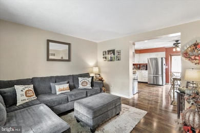
Welcome to this charming and well-maintained home offering 3 bedrooms and 2 full bathrooms, including a main-level primary bedroom with its own attached full bath. Convenience is key—this home features main level laundry, spacious living areas, and great closet space in all three bedrooms. Outside, enjoy a fully fenced yard, perfect for pets, play, or gardening. There’s off-street parking along with a detached carport for covered vehicle storage. Located in a quiet Cresaptown neighborhood, this property offers comfort, practicality, and easy everyday living. Move-in ready and full of value—come take a look!
Home Details
Home Type
- Single Family
Est. Annual Taxes
- $1,667
Year Built
- Built in 2000
Lot Details
- 7,500 Sq Ft Lot
- Property is Fully Fenced
- Chain Link Fence
- Property is in excellent condition
Home Design
- Cape Cod Architecture
- Permanent Foundation
- Shingle Roof
- Vinyl Siding
Interior Spaces
- Property has 2 Levels
- Ceiling Fan
- Living Room
Kitchen
- Eat-In Kitchen
- Stove
- Microwave
- Ice Maker
- Dishwasher
- Disposal
Bedrooms and Bathrooms
Laundry
- Laundry Room
- Laundry on main level
- Washer and Dryer Hookup
Unfinished Basement
- Walk-Out Basement
- Partial Basement
- Rear Basement Entry
Parking
- 2 Parking Spaces
- 1 Driveway Space
- 1 Detached Carport Space
Outdoor Features
- Porch
Schools
- Cresaptown Elementary School
- Braddock Middle School
- Allegany High School
Utilities
- Forced Air Heating and Cooling System
- Electric Water Heater
Community Details
- No Home Owners Association
- Cresaptown Subdivision
Listing and Financial Details
- Assessor Parcel Number 0107020058
Map
Home Values in the Area
Average Home Value in this Area
Tax History
| Year | Tax Paid | Tax Assessment Tax Assessment Total Assessment is a certain percentage of the fair market value that is determined by local assessors to be the total taxable value of land and additions on the property. | Land | Improvement |
|---|---|---|---|---|
| 2025 | $1,823 | $153,400 | $16,100 | $137,300 |
| 2024 | $1,945 | $142,867 | $0 | $0 |
| 2023 | $1,383 | $132,333 | $0 | $0 |
| 2022 | $1,787 | $121,800 | $13,500 | $108,300 |
| 2021 | $1,770 | $121,800 | $13,500 | $108,300 |
| 2020 | $1,787 | $121,800 | $13,500 | $108,300 |
| 2019 | $1,906 | $129,900 | $15,000 | $114,900 |
| 2018 | $1,819 | $126,333 | $0 | $0 |
| 2017 | $1,735 | $122,767 | $0 | $0 |
| 2016 | $0 | $119,200 | $0 | $0 |
| 2015 | $1,751 | $119,133 | $0 | $0 |
| 2014 | $1,751 | $119,067 | $0 | $0 |
Property History
| Date | Event | Price | List to Sale | Price per Sq Ft |
|---|---|---|---|---|
| 11/01/2025 11/01/25 | For Sale | $216,000 | -- | $150 / Sq Ft |
Purchase History
| Date | Type | Sale Price | Title Company |
|---|---|---|---|
| Deed | $110,000 | Maryland Title Center Llc | |
| Deed | $115,000 | -- | |
| Deed | $19,000 | -- |
Mortgage History
| Date | Status | Loan Amount | Loan Type |
|---|---|---|---|
| Open | $6,293 | Construction | |
| Open | $106,060 | New Conventional | |
| Previous Owner | $85,000 | Purchase Money Mortgage |
Source: Bright MLS
MLS Number: MDAL2013264
APN: 07-020058
Disclaimer: Certain information contained herein is derived from information provided by parties other than Homes.com. All information provided is deemed reliable, but is not guaranteed to be accurate and should be independently verified.
![]() The data relating to real estate for sale on this website appears in part through the BRIGHT Internet Data Exchange program, a voluntary cooperative exchange of property listing data between licensed real estate brokerage firms, and is provided by BRIGHT through a licensing agreement.
The data relating to real estate for sale on this website appears in part through the BRIGHT Internet Data Exchange program, a voluntary cooperative exchange of property listing data between licensed real estate brokerage firms, and is provided by BRIGHT through a licensing agreement.
Listing information is from various brokers who participate in the Bright MLS IDX program and not all listings may be visible on the site.
The property information being provided on or through the website is for the personal, non-commercial use of consumers and such information may not be used for any purpose other than to identify prospective properties consumers may be interested in purchasing.
Some properties which appear for sale on the website may no longer be available because they are for instance, under contract, sold or are no longer being offered for sale.
Property information displayed is deemed reliable but is not guaranteed.
Copyright 2025 Bright MLS, Inc.
- 14801 Connecticut Ave
- 11813 Illinois Ave
- 0 Fir Tree Ln Unit MDAL2012106
- 14620 Redwood St
- 14804 Bell St
- 15104 Truly Dr SW
- 14104 Louise Dr SW
- 14003 Cedarwood Dr SW
- 14210 Walter Dr SW
- 14716 Howard St
- LOT 127 Howard St
- 14201 Winchester Rd SW
- 14526 Mcmullen Hwy SW
- 0 Oakwood St
- 14308L Greenfield Crescent SW
- 14605 Mcgill Dr SW
- 14200 Stonefield Ln
- 15708 Downing St SW
- 15609 Westwood Rd SW
- 15700 Acorn Ct SW
- 215 E Elder St
- 328 Virginia Ave Unit A
- 307 Arch St
- 356 National Hwy Unit Upstairs level
- 108 Springdale St
- 113 Grand Ave
- 124-126 Greene St Unit 124 Basement
- 328 Fayette St Unit 10
- 36 Hawthorne Ave
- 13 Somerville Ave
- 143 Washington St Unit B
- 759 Maryland Ave Unit 1
- 14818 Broadway St
- 740 N Mechanic St
- 201 Spring St Unit Lower
- 201 Spring St Unit Upper
- 529 N Centre St Unit Rear
- 623 Columbia Ave Unit B
- 623 Columbia Ave Unit C
- 191 Park Ave
