Estimated Value: $204,778 - $623,000
Studio
--
Bath
1,632
Sq Ft
$314/Sq Ft
Est. Value
About This Home
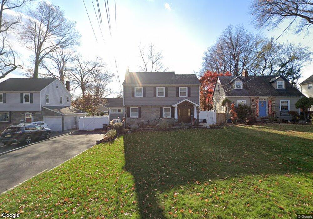
This home is located at 1372 Beverly Rd, Union, NJ 07083 and is currently estimated at $512,695, approximately $314 per square foot. 1372 Beverly Rd is a home located in Union County with nearby schools including Livingston Elementary School, Union High School, and St Michael Parish School.
Ownership History
Date
Name
Owned For
Owner Type
Purchase Details
Closed on
Dec 13, 2021
Sold by
Depergola Sophia
Bought by
Depergola Sophia and Depergola John
Current Estimated Value
Home Financials for this Owner
Home Financials are based on the most recent Mortgage that was taken out on this home.
Original Mortgage
$272,000
Outstanding Balance
$200,817
Interest Rate
2.98%
Mortgage Type
New Conventional
Estimated Equity
$311,878
Purchase Details
Closed on
Aug 18, 2009
Sold by
Higgins Edward F
Bought by
Costa Sophia
Home Financials for this Owner
Home Financials are based on the most recent Mortgage that was taken out on this home.
Original Mortgage
$256,000
Interest Rate
5.31%
Mortgage Type
New Conventional
Create a Home Valuation Report for This Property
The Home Valuation Report is an in-depth analysis detailing your home's value as well as a comparison with similar homes in the area
Home Values in the Area
Average Home Value in this Area
Purchase History
| Date | Buyer | Sale Price | Title Company |
|---|---|---|---|
| Depergola Sophia | -- | Hunter Title Agency Inc | |
| Depergola Sophia | -- | Hunter Title | |
| Costa Sophia | $320,000 | None Available |
Source: Public Records
Mortgage History
| Date | Status | Borrower | Loan Amount |
|---|---|---|---|
| Open | Depergola Sophia | $272,000 | |
| Closed | Depergola Sophia | $272,000 | |
| Previous Owner | Costa Sophia | $256,000 |
Source: Public Records
Tax History
| Year | Tax Paid | Tax Assessment Tax Assessment Total Assessment is a certain percentage of the fair market value that is determined by local assessors to be the total taxable value of land and additions on the property. | Land | Improvement |
|---|---|---|---|---|
| 2025 | $10,661 | $47,700 | $20,400 | $27,300 |
| 2024 | $10,336 | $47,700 | $20,400 | $27,300 |
| 2023 | $10,336 | $47,700 | $20,400 | $27,300 |
| 2022 | $9,977 | $47,700 | $20,400 | $27,300 |
| 2021 | $9,735 | $47,700 | $20,400 | $27,300 |
| 2020 | $9,541 | $47,700 | $20,400 | $27,300 |
| 2019 | $9,413 | $47,700 | $20,400 | $27,300 |
| 2018 | $9,252 | $47,700 | $20,400 | $27,300 |
| 2017 | $9,115 | $47,700 | $20,400 | $27,300 |
| 2016 | $8,893 | $47,700 | $20,400 | $27,300 |
| 2015 | $8,746 | $47,700 | $20,400 | $27,300 |
| 2014 | $8,550 | $47,700 | $20,400 | $27,300 |
Source: Public Records
Map
Nearby Homes
- 950 Carteret Ave
- 970 Lorraine Ave
- 321 Sherwood Rd
- 980 Salem Rd
- 875 Salem Rd
- 1453 Morris Ave
- 985 Arnet Ave
- 306 Minute Arms Rd
- 1090 Salem Rd
- 5 Station Square
- 951 Liberty Ave
- 1393 Cornell Place
- 130 Valley View Rd
- 602 Salem Rd
- 1272 Robinson Terrace
- 558 Schuyler Way
- 569 Scotland Rd
- 444 Wheaton Rd
- 760 Summit Rd
- 1611 N Sunset Place
Your Personal Tour Guide
Ask me questions while you tour the home.