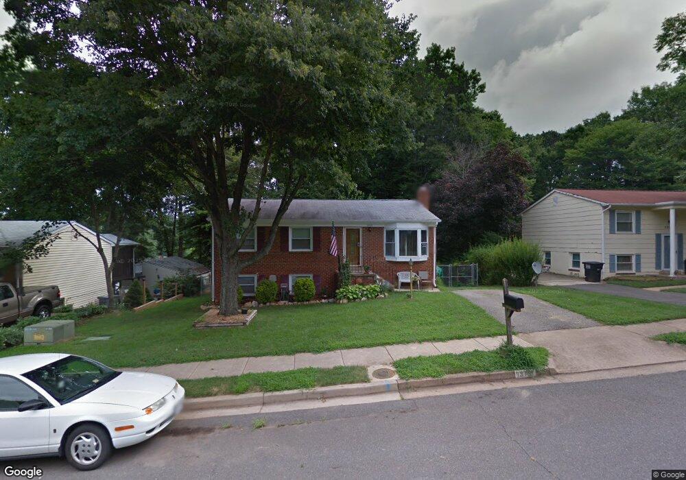
13731 Lynhurst Dr Woodbridge, VA 22193
Lindendale NeighborhoodEstimated Value: $490,000 - $497,071
4
Beds
3
Baths
988
Sq Ft
$499/Sq Ft
Est. Value
About This Home
This home is located at 13731 Lynhurst Dr, Woodbridge, VA 22193 and is currently estimated at $493,018, approximately $499 per square foot. 13731 Lynhurst Dr is a home located in Prince William County with nearby schools including Enterprise Elementary School, C.D. Hylton High School, and Stuart M. Beville Middle School.
Ownership History
Date
Name
Owned For
Owner Type
Purchase Details
Closed on
Sep 2, 1998
Sold by
Sec Of Va
Bought by
Tinker Gerald L and Tinker Dorothy J
Current Estimated Value
Home Financials for this Owner
Home Financials are based on the most recent Mortgage that was taken out on this home.
Original Mortgage
$120,100
Outstanding Balance
$25,655
Interest Rate
6.9%
Mortgage Type
VA
Estimated Equity
$467,363
Create a Home Valuation Report for This Property
The Home Valuation Report is an in-depth analysis detailing your home's value as well as a comparison with similar homes in the area
Home Values in the Area
Average Home Value in this Area
Purchase History
| Date | Buyer | Sale Price | Title Company |
|---|---|---|---|
| Tinker Gerald L | $120,100 | -- |
Source: Public Records
Mortgage History
| Date | Status | Borrower | Loan Amount |
|---|---|---|---|
| Open | Tinker Gerald L | $120,100 |
Source: Public Records
Tax History Compared to Growth
Tax History
| Year | Tax Paid | Tax Assessment Tax Assessment Total Assessment is a certain percentage of the fair market value that is determined by local assessors to be the total taxable value of land and additions on the property. | Land | Improvement |
|---|---|---|---|---|
| 2025 | $3,871 | $423,200 | $145,700 | $277,500 |
| 2024 | $3,871 | $389,200 | $135,700 | $253,500 |
| 2023 | $3,924 | $377,100 | $132,900 | $244,200 |
| 2022 | $4,101 | $360,000 | $123,100 | $236,900 |
| 2021 | $4,054 | $329,400 | $110,900 | $218,500 |
| 2020 | $4,435 | $286,100 | $104,600 | $181,500 |
| 2019 | $4,383 | $282,800 | $100,600 | $182,200 |
| 2018 | $3,272 | $271,000 | $97,700 | $173,300 |
| 2017 | $3,167 | $253,400 | $92,200 | $161,200 |
| 2016 | $3,043 | $245,500 | $89,600 | $155,900 |
| 2015 | $2,802 | $234,200 | $86,600 | $147,600 |
| 2014 | $2,802 | $220,600 | $84,200 | $136,400 |
Source: Public Records
Map
Nearby Homes
- 13871 Langstone Dr
- 4800 Korvett Dr
- 13732 Moccasin Ct
- 13652 Kingsman Rd
- 4690 Pearson Dr
- 13509 Delaney Rd
- 14160 Landon Ln
- 4903 Kenyon Ct
- 13626 Kingsman Rd
- 13540 Kaslo Dr
- 5308 Macwood Dr
- 13546 Kaslo Dr
- 14010 Mapledale Ave
- 13441 Kerr Ct
- 14591 Estate Dr
- 13324 Kirkdale Ct
- 13612 Kerrydale Rd
- 5207 Quiet Place
- 4811 Kirkdale Dr
- 13424 Keating Dr
- 13733 Lynhurst Dr
- 13729 Lynhurst Dr
- 13735 Lynhurst Dr
- 13727 Lynhurst Dr
- 4961 Linsey Ct
- 4963 Linsey Ct
- 4959 Linsey Ct
- 4981 Landover Ct
- 4965 Linsey Ct
- 13725 Lynhurst Dr
- 13737 Lynhurst Dr
- 13736 Lynhurst Dr
- 4957 Linsey Ct
- 4980 Landover Ct
- 4878 Langer Ln
- 13830 Londonderry Ct
- 4983 Landover Ct
- 13828 Londonderry Ct
- 13728 Lynhurst Dr
- 13738 Lynhurst Dr