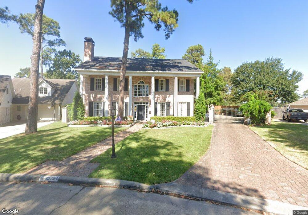
13754 Kingsride Ln Houston, TX 77079
Memorial NeighborhoodEstimated Value: $1,861,000 - $1,967,000
5
Beds
5
Baths
5,198
Sq Ft
$366/Sq Ft
Est. Value
About This Home
This home is located at 13754 Kingsride Ln, Houston, TX 77079 and is currently estimated at $1,901,639, approximately $365 per square foot. 13754 Kingsride Ln is a home located in Harris County with nearby schools including Wilchester Elementary School, Memorial Middle, and Stratford High School.
Ownership History
Date
Name
Owned For
Owner Type
Purchase Details
Closed on
Apr 11, 2019
Sold by
Osso Anthony and Osso Virginia
Bought by
Atkinson Management Trust
Current Estimated Value
Home Financials for this Owner
Home Financials are based on the most recent Mortgage that was taken out on this home.
Original Mortgage
$1,372,750
Outstanding Balance
$1,206,891
Interest Rate
4.3%
Mortgage Type
Commercial
Estimated Equity
$694,748
Purchase Details
Closed on
Mar 14, 2000
Sold by
Mclaughlin Brenda Cherry
Bought by
Osso Anthony and Osso Virginia
Create a Home Valuation Report for This Property
The Home Valuation Report is an in-depth analysis detailing your home's value as well as a comparison with similar homes in the area
Home Values in the Area
Average Home Value in this Area
Purchase History
| Date | Buyer | Sale Price | Title Company |
|---|---|---|---|
| Atkinson Management Trust | -- | Fidelity National Title | |
| Osso Anthony | -- | -- |
Source: Public Records
Mortgage History
| Date | Status | Borrower | Loan Amount |
|---|---|---|---|
| Open | Atkinson Management Trust | $1,372,750 |
Source: Public Records
Tax History Compared to Growth
Tax History
| Year | Tax Paid | Tax Assessment Tax Assessment Total Assessment is a certain percentage of the fair market value that is determined by local assessors to be the total taxable value of land and additions on the property. | Land | Improvement |
|---|---|---|---|---|
| 2025 | $27,494 | $1,855,585 | $777,000 | $1,078,585 |
| 2024 | $27,494 | $1,834,515 | $777,000 | $1,057,515 |
| 2023 | $27,494 | $1,762,935 | $777,000 | $985,935 |
| 2022 | $31,305 | $1,338,992 | $738,150 | $600,842 |
| 2021 | $32,210 | $1,319,280 | $712,250 | $607,030 |
| 2020 | $32,812 | $1,309,541 | $712,250 | $597,291 |
| 2019 | $28,510 | $1,304,994 | $712,250 | $592,744 |
| 2018 | $9,690 | $990,000 | $712,250 | $277,750 |
| 2017 | $25,899 | $990,000 | $549,588 | $440,412 |
| 2016 | $25,899 | $990,000 | $549,588 | $440,412 |
| 2015 | $19,486 | $990,000 | $549,588 | $440,412 |
| 2014 | $19,486 | $925,000 | $379,715 | $545,285 |
Source: Public Records
Map
Nearby Homes
- 807 Patchester Dr
- 710 Patchester Dr
- 13931 Kingsride Ln
- 1110 W Tri Oaks Ln Unit 157
- 14122 Barryknoll Ln
- 1108 W Tri Oaks Ln Unit 150
- 14135 Kimberley Ln
- 11411 Ash Creek Dr
- 14123 Misty Meadow Ln
- 11402 Ash Creek Dr
- 13403 Taylorcrest Rd
- 807 Wycliffe Dr
- 14143 Lost Meadow Ln
- 14171 Misty Meadow Ln
- 14151 Lost Meadow Ln
- 903 Wycliffe Dr
- 14226 Misty Meadow Ln
- 14228 Misty Meadow Ln
- 11102 Savannah Oaks Ln
- 1144 N Kirkwood Rd Unit 1144
- 823 Patchester Dr
- 13750 Kingsride Ln
- 826 W Forest Dr
- 822 W Forest Dr
- 13746 Kingsride Ln
- 830 W Forest Dr
- 819 Patchester Dr
- 13751 Kingsride Ln
- 818 W Forest Dr
- 834 W Forest Dr
- 13747 Kingsride Ln
- 13742 Kingsride Ln
- 814 W Forest Dr
- 838 W Forest Dr
- 13743 Kingsride Ln
- 13803 Queensbury Ln
- 13738 Kingsride Ln
- 811 Patchester Dr
- 810 W Forest Dr
- 13802 Queensbury Ln