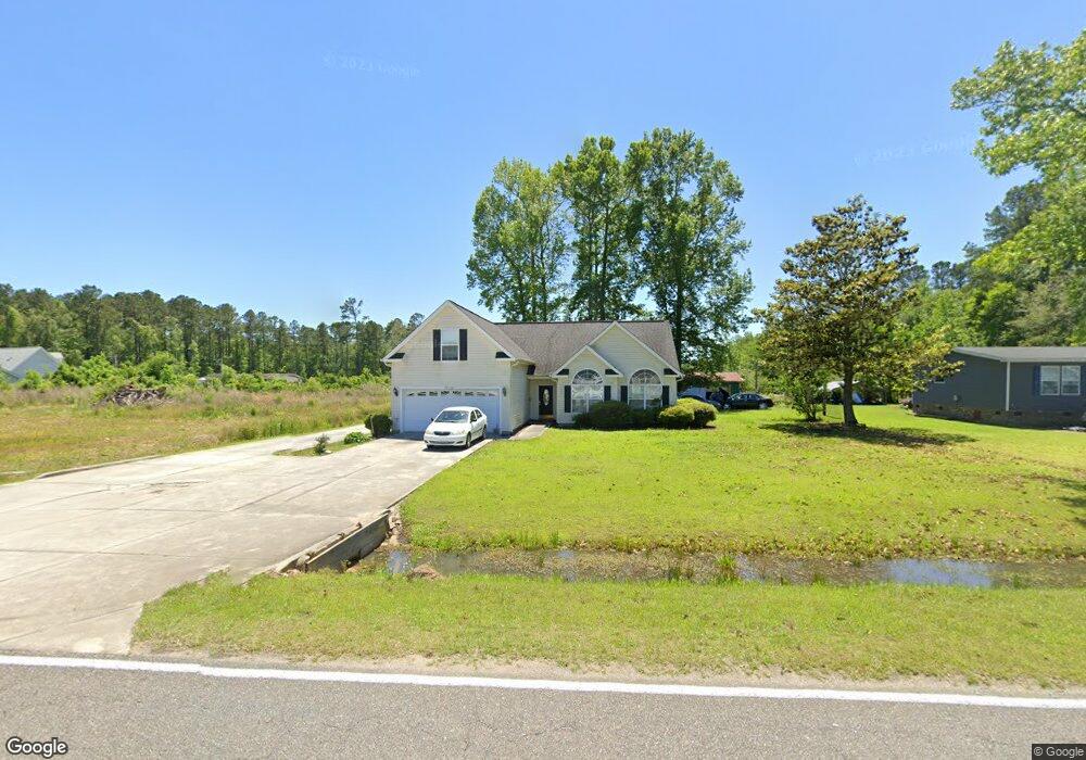
1377 Dirty Branch Rd Conway, SC 29527
Estimated Value: $292,000 - $326,000
3
Beds
2
Baths
1,704
Sq Ft
$179/Sq Ft
Est. Value
About This Home
This home is located at 1377 Dirty Branch Rd, Conway, SC 29527 and is currently estimated at $305,074, approximately $179 per square foot. 1377 Dirty Branch Rd is a home located in Horry County with nearby schools including Pee Dee Elementary School, Whittemore Park Middle School, and Conway High School.
Ownership History
Date
Name
Owned For
Owner Type
Purchase Details
Closed on
Mar 15, 2006
Sold by
Spain Arnold
Bought by
Spain Arnold and Spain Dina Marie
Current Estimated Value
Purchase Details
Closed on
Sep 2, 2004
Sold by
Blain John and Spain Laura B
Bought by
Spain Arnold
Create a Home Valuation Report for This Property
The Home Valuation Report is an in-depth analysis detailing your home's value as well as a comparison with similar homes in the area
Home Values in the Area
Average Home Value in this Area
Purchase History
| Date | Buyer | Sale Price | Title Company |
|---|---|---|---|
| Spain Arnold | -- | None Available | |
| Spain Arnold | -- | -- |
Source: Public Records
Tax History Compared to Growth
Tax History
| Year | Tax Paid | Tax Assessment Tax Assessment Total Assessment is a certain percentage of the fair market value that is determined by local assessors to be the total taxable value of land and additions on the property. | Land | Improvement |
|---|---|---|---|---|
| 2024 | $769 | $17,899 | $5,227 | $12,672 |
| 2023 | $769 | $6,421 | $852 | $5,569 |
| 2021 | $697 | $12,174 | $1,350 | $10,824 |
| 2020 | $603 | $12,174 | $1,350 | $10,824 |
| 2019 | $603 | $12,174 | $1,350 | $10,824 |
| 2018 | $544 | $8,376 | $1,110 | $7,266 |
| 2017 | $529 | $8,376 | $1,110 | $7,266 |
| 2016 | -- | $8,376 | $1,110 | $7,266 |
| 2015 | $529 | $8,376 | $1,110 | $7,266 |
| 2014 | $489 | $5,584 | $740 | $4,844 |
Source: Public Records
Map
Nearby Homes
- 3120 Merganser Dr
- 3524 Merganser Dr
- 3230 Merganser Dr
- 1300 Ruddy Ct
- 5241 Cates Bay Hwy
- 7.4 Acs Cates Bay Hwy Unit Lot 10
- 5.47 Acs Cates Bay Hwy Unit Lot 4
- 6.97 Acs Cates Bay Hwy Unit Lot 12
- 19.09 Acs Cates Bay Hwy Unit Lot 11
- 5.73 Acs Cates Bay Hwy Unit Lot 5
- 6.84 Acs Cates Bay Hwy Unit Lot 8
- 7.39 Acs Cates Bay Hwy Unit Lot 9
- 9.33 Acs Cates Bay Hwy Unit Lot 13
- 1048 Cadbury Ct
- 1049 Augustus Dr
- 632 Golden Resin Rd Unit Lot 190
- 628 Golden Resin Rd
- 632 Golden Resin Rd
- 628 Golden Resin Rd Unit Lot 191
- 1036 Augustus Dr
- 1381 Dirty Branch Rd
- 1305 Mandarin Dr
- 1305 Mandarin Dr Unit Lot 02 Kingston Plan
- 1050 Forest Acres Ln
- 1305 Dirty Branch Rd
- 1301 Mandarin Dr Unit Lot 01 Abaco Plan
- 3620 Merganser Dr
- 3620 Merganser Dr Unit Lot 74 Busbee Plan
- 1313 Mandarin Dr
- 1313 Mandarin Dr Unit Lot 04 Kingston Plan
- 1317 Mandarin Dr
- 1317 Mandarin Dr Unit Lot 05 Dogwood Plan
- 1300 Mandarin Dr Unit Lot 75 Oak II Plan
- 1300 Mandarin Dr
- 3616 Merganser Dr Unit Lot 73 Kingston Plan
- 1321 Merganser Dr
- 1304 Mandarin Dr
- 1304 Mandarin Dr Unit Lot 76 Dogwood Plan
- 1308 Mandarin Dr Unit Lot 77 Kingston Plan
- 3612 Merganser Dr Unit Lot 72 Kingston Plan