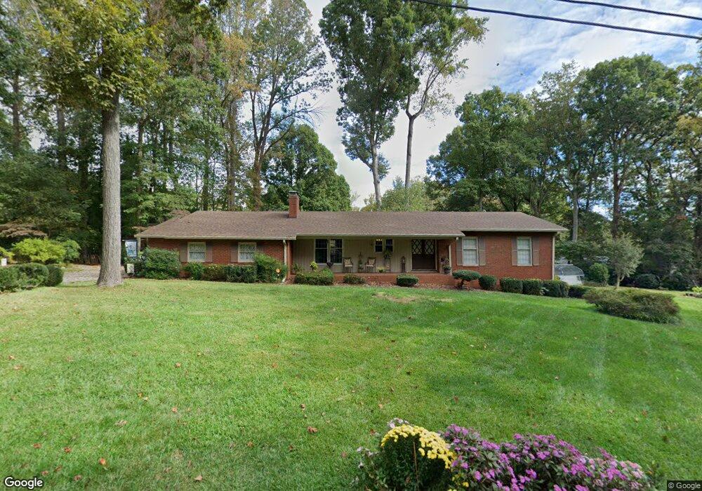
138 Ashbrook Rd Statesville, NC 28677
Estimated Value: $282,842 - $344,000
3
Beds
2
Baths
1,628
Sq Ft
$187/Sq Ft
Est. Value
About This Home
This home is located at 138 Ashbrook Rd, Statesville, NC 28677 and is currently estimated at $305,211, approximately $187 per square foot. 138 Ashbrook Rd is a home located in Iredell County with nearby schools including Celeste Henkel Elementary School, West Iredell Middle School, and West Iredell High School.
Ownership History
Date
Name
Owned For
Owner Type
Purchase Details
Closed on
Aug 17, 2018
Sold by
Kopp Joseph A and Kopp Catherine J
Bought by
Koop Joseph A and Koop Catherine J
Current Estimated Value
Purchase Details
Closed on
May 3, 2010
Sold by
Kopp Joseph A and Kopp Catherine J
Bought by
Kopp Jonathan David and Kopp David Joseph
Purchase Details
Closed on
Jun 1, 1978
Purchase Details
Closed on
Jun 1, 1970
Create a Home Valuation Report for This Property
The Home Valuation Report is an in-depth analysis detailing your home's value as well as a comparison with similar homes in the area
Home Values in the Area
Average Home Value in this Area
Purchase History
| Date | Buyer | Sale Price | Title Company |
|---|---|---|---|
| Koop Joseph A | -- | None Available | |
| Kopp Jonathan David | -- | None Available | |
| -- | $59,000 | -- | |
| -- | -- | -- |
Source: Public Records
Tax History Compared to Growth
Tax History
| Year | Tax Paid | Tax Assessment Tax Assessment Total Assessment is a certain percentage of the fair market value that is determined by local assessors to be the total taxable value of land and additions on the property. | Land | Improvement |
|---|---|---|---|---|
| 2024 | $1,532 | $249,560 | $50,000 | $199,560 |
| 2023 | $1,532 | $249,560 | $50,000 | $199,560 |
| 2022 | $1,178 | $178,190 | $40,000 | $138,190 |
| 2021 | $1,116 | $168,870 | $40,000 | $128,870 |
| 2020 | $1,116 | $168,870 | $40,000 | $128,870 |
| 2019 | $1,099 | $168,870 | $40,000 | $128,870 |
| 2018 | $882 | $138,830 | $34,000 | $104,830 |
| 2017 | $882 | $138,830 | $34,000 | $104,830 |
| 2016 | $882 | $138,830 | $34,000 | $104,830 |
| 2015 | $882 | $138,830 | $34,000 | $104,830 |
| 2014 | $917 | $155,870 | $34,000 | $121,870 |
Source: Public Records
Map
Nearby Homes
- 00 Jamie Dr Unit 6
- 130 Aviation Dr
- 116 Bent Twig Dr
- 827 Flint Dr
- 908 Westminster Dr
- 3004 Newton Dr
- 3606 Rose St Unit 55
- 178 Old Airport Rd
- 2844 Hickory Hwy
- 140 Swan Park Ln Unit 16
- 128 Swan Park Ln Unit 18
- 104 Swan Park Ln Unit 22
- 130 Greenwich Dr
- 103 Dublin Ct
- 109 Gatwick Ct
- 289 Mary Locke Way
- Robie Plan at Bristol Terrace
- Penwell Plan at Bristol Terrace
- Hayden Plan at Bristol Terrace
- 119 Mary Locke Way
- 165 Jamie Dr
- 161 Jamie Dr
- 137 Ashbrook Rd
- 126 Ashbrook Rd
- 147 Ashbrook Rd
- 153 Jamie Dr
- 171 Jamie Dr
- 150 Ashbrook Rd
- Lot 6 Jamie Dr
- 129 Ashbrook Rd
- 189 Jamie Dr
- 155 Ashbrook Rd
- 154 Ashbrook Rd
- 156 Jamie Dr
- 156 Jamie Dr Unit 6-7
- 147 Jamie Dr
- 160 Jamie Dr
- 116 Ashbrook Rd
- 123 Ashbrook Rd
- 123 Ashbrook Rd