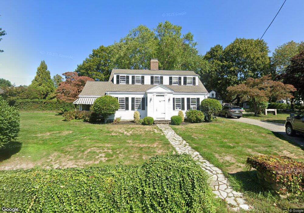
138 Elm St Scituate, MA 02066
Estimated Value: $854,000 - $1,279,000
3
Beds
3
Baths
2,520
Sq Ft
$428/Sq Ft
Est. Value
About This Home
This home is located at 138 Elm St, Scituate, MA 02066 and is currently estimated at $1,079,495, approximately $428 per square foot. 138 Elm St is a home located in Plymouth County with nearby schools including Cushing Elementary School, Lester J. Gates Middle School, and Scituate High School.
Ownership History
Date
Name
Owned For
Owner Type
Purchase Details
Closed on
Nov 30, 1993
Sold by
Carr Howell C and Carr Helen E
Bought by
Doherty Robert C and Doherty Kelly A
Current Estimated Value
Home Financials for this Owner
Home Financials are based on the most recent Mortgage that was taken out on this home.
Original Mortgage
$231,750
Interest Rate
6.72%
Mortgage Type
Purchase Money Mortgage
Create a Home Valuation Report for This Property
The Home Valuation Report is an in-depth analysis detailing your home's value as well as a comparison with similar homes in the area
Home Values in the Area
Average Home Value in this Area
Purchase History
| Date | Buyer | Sale Price | Title Company |
|---|---|---|---|
| Doherty Robert C | $257,500 | -- |
Source: Public Records
Mortgage History
| Date | Status | Borrower | Loan Amount |
|---|---|---|---|
| Open | Doherty Robert C | $217,000 | |
| Closed | Doherty Robert C | $199,000 | |
| Closed | Doherty Robert C | $215,500 | |
| Closed | Doherty Robert C | $231,750 |
Source: Public Records
Tax History Compared to Growth
Tax History
| Year | Tax Paid | Tax Assessment Tax Assessment Total Assessment is a certain percentage of the fair market value that is determined by local assessors to be the total taxable value of land and additions on the property. | Land | Improvement |
|---|---|---|---|---|
| 2025 | $8,919 | $892,800 | $389,400 | $503,400 |
| 2024 | $9,283 | $896,000 | $354,000 | $542,000 |
| 2023 | $9,235 | $829,700 | $339,700 | $490,000 |
| 2022 | $9,160 | $725,800 | $311,500 | $414,300 |
| 2021 | $3,482 | $670,400 | $296,700 | $373,700 |
| 2020 | $3,393 | $642,200 | $285,200 | $357,000 |
| 2019 | $8,550 | $622,300 | $279,700 | $342,600 |
| 2018 | $3,164 | $597,700 | $277,900 | $319,800 |
| 2017 | $8,258 | $586,100 | $266,300 | $319,800 |
| 2016 | $7,959 | $562,900 | $243,100 | $319,800 |
| 2015 | $7,223 | $551,400 | $231,600 | $319,800 |
Source: Public Records
Map
Nearby Homes
- 115 Elm St
- 111 Elm St
- 290 Beaver Dam Rd
- 18 James Way
- 13 Hornbeam Rd
- 74 Tilden Rd
- 116 Old Forge Rd
- 148 Tilden Rd
- 76 A Brook St
- 76 A Brook St Unit 1
- 12 Sassamon Rd
- 22 Kings Way
- 14 Aberdeen Dr
- 54 Woodland Rd
- 50 First Parish Rd
- 19 Ford Place Unit 3
- 19 Ford Place Unit 1
- 19 Ford Place Unit 4
- 17 Old Oaken Bucket Rd
- 2 Windward Ln
- lot 40 Walnut Tree Hill Dr
- LOT 7 Tanglewood
- LOT 8 Persimmon Rd
- LOT 12 Fox Vine Lane 18
- LOT 10 Heritage Trail
- LOT4 Heritage Trail
- LOT 20 Cushing Estates
- 137 Elm St
- 9 Meadow Ln
- 9 Meadow Ln Unit R
- 144 Elm St
- 133 Elm St
- 268 Country Way
- 268 Country Way
- 126 Elm St
- 6 Meadow Ln
- 6 Meadow Ln
- 3 Grace Way Unit 3
- 6 Grace Way Unit 6
- 1 Grace Way Unit 1