Estimated Value: $322,000 - $479,000
3
Beds
3
Baths
2,787
Sq Ft
$139/Sq Ft
Est. Value
About This Home
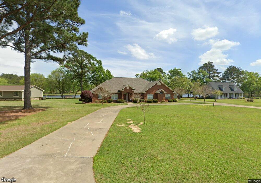
This home is located at 138 Shellcracker Dr, Cairo, GA 39827 and is currently estimated at $387,124, approximately $138 per square foot. 138 Shellcracker Dr is a home located in Grady County with nearby schools including Cairo High School.
Ownership History
Date
Name
Owned For
Owner Type
Purchase Details
Closed on
Aug 12, 2020
Sold by
Creech William Floyd
Bought by
William And Glenda Creech Irrev Trust
Current Estimated Value
Purchase Details
Closed on
Aug 23, 2012
Sold by
Creech Glenda C
Bought by
Creech William Floyd and Creech Glenda C
Purchase Details
Closed on
Mar 1, 2000
Bought by
Creech Glenda
Purchase Details
Closed on
Apr 18, 1996
Sold by
First National Bank
Bought by
Creech Floyd
Purchase Details
Closed on
Jan 2, 1996
Sold by
Robinson Urban
Bought by
First National Bank
Purchase Details
Closed on
Jun 11, 1990
Bought by
Robinson Urban
Create a Home Valuation Report for This Property
The Home Valuation Report is an in-depth analysis detailing your home's value as well as a comparison with similar homes in the area
Purchase History
| Date | Buyer | Sale Price | Title Company |
|---|---|---|---|
| William And Glenda Creech Irrev Trust | -- | -- | |
| Creech William Floyd | -- | -- | |
| Creech Glenda | -- | -- | |
| Creech Floyd | $11,500 | -- | |
| First National Bank | -- | -- | |
| Robinson Urban | $9,000 | -- |
Source: Public Records
Tax History
| Year | Tax Paid | Tax Assessment Tax Assessment Total Assessment is a certain percentage of the fair market value that is determined by local assessors to be the total taxable value of land and additions on the property. | Land | Improvement |
|---|---|---|---|---|
| 2024 | $3,013 | $166,228 | $9,810 | $156,418 |
| 2023 | $3,006 | $99,636 | $9,540 | $90,096 |
| 2022 | $3,006 | $99,636 | $9,540 | $90,096 |
| 2021 | $3,015 | $99,636 | $9,540 | $90,096 |
| 2020 | $3,026 | $99,636 | $9,540 | $90,096 |
| 2019 | $3,026 | $99,636 | $9,540 | $90,096 |
| 2018 | $2,840 | $99,636 | $9,540 | $90,096 |
| 2017 | $2,704 | $99,636 | $9,540 | $90,096 |
| 2016 | $2,337 | $85,912 | $9,540 | $76,372 |
| 2015 | $2,309 | $85,912 | $9,540 | $76,372 |
| 2014 | $2,312 | $85,912 | $9,540 | $76,372 |
| 2013 | -- | $83,750 | $9,540 | $74,210 |
Source: Public Records
Map
Nearby Homes
- 00 State Route 188
- 0 State Route 188
- 414 Woodland Rd
- 2690 U S 84
- 78.6 Ac Strickland Rd
- 408 Bay Tree Rd NE
- 3109 U S 84
- 3109 U S 84
- 0 20th St NE
- 00 20th St NE
- 66 22nd St NE
- 21 24th St NE
- 711 2nd Ave NE
- 3136 State Route 188
- 2975 U S 84
- 592 20th St SE
- 00 Blackberry Ln
- 00 Meridian Rd
- 1420 Parallel Dr NW
- 4761 Hadley Ferry Rd
- 160 Shellcracker Dr
- Lot 6 Shellcracker Dr
- 124 Shellcracker Dr
- 155 Shellcracker Dr
- 133 Shellcracker Dr
- 110 Shellcracker Dr
- 175 Shellcracker Dr
- 113 Shellcracker Dr
- 171 Wood Duck Dr
- 183 Shellcracker Dr
- 181 Wood Duck Dr
- 157 Wood Duck Dr
- 145 Wood Duck Dr
- 2029 Ga Highway 188 N
- Lot # 6 Wood Duck Ln
- 00 Wood Duck Ln
- 000 Wood Duck Ln
- 1965 Ga Highway 188 N
- 129 Wood Duck Dr
- 111 Wood Duck Dr
Your Personal Tour Guide
Ask me questions while you tour the home.