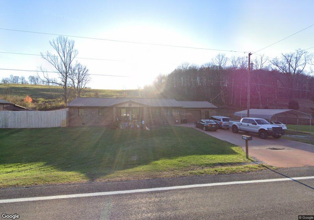
13816 State Route 73 Mc Dermott, OH 45652
Estimated Value: $253,000 - $296,000
3
Beds
2
Baths
2,184
Sq Ft
$126/Sq Ft
Est. Value
About This Home
This home is located at 13816 State Route 73, Mc Dermott, OH 45652 and is currently estimated at $274,300, approximately $125 per square foot. 13816 State Route 73 is a home located in Scioto County with nearby schools including Northwest Elementary School, Northwest Middle School, and Northwest High School.
Ownership History
Date
Name
Owned For
Owner Type
Purchase Details
Closed on
Sep 6, 2024
Sold by
Penn Sheryl L
Bought by
Bender Joshua M and Bender Amy
Current Estimated Value
Home Financials for this Owner
Home Financials are based on the most recent Mortgage that was taken out on this home.
Original Mortgage
$250,871
Outstanding Balance
$248,187
Interest Rate
6.73%
Mortgage Type
FHA
Estimated Equity
$26,113
Purchase Details
Closed on
Jan 1, 1987
Bought by
Penn David C + Sheryl L
Create a Home Valuation Report for This Property
The Home Valuation Report is an in-depth analysis detailing your home's value as well as a comparison with similar homes in the area
Purchase History
| Date | Buyer | Sale Price | Title Company |
|---|---|---|---|
| Bender Joshua M | $255,500 | Bestitle Agency | |
| Penn David C + Sheryl L | -- | -- |
Source: Public Records
Mortgage History
| Date | Status | Borrower | Loan Amount |
|---|---|---|---|
| Open | Bender Joshua M | $250,871 |
Source: Public Records
Tax History
| Year | Tax Paid | Tax Assessment Tax Assessment Total Assessment is a certain percentage of the fair market value that is determined by local assessors to be the total taxable value of land and additions on the property. | Land | Improvement |
|---|---|---|---|---|
| 2024 | $2,906 | $64,120 | $4,610 | $59,510 |
| 2023 | $2,144 | $64,120 | $4,610 | $59,510 |
| 2022 | $2,136 | $64,120 | $4,610 | $59,510 |
| 2021 | $1,877 | $57,700 | $3,990 | $53,710 |
| 2020 | $2,209 | $57,700 | $3,990 | $53,710 |
| 2019 | $2,205 | $54,630 | $3,960 | $50,670 |
| 2018 | $2,113 | $54,630 | $3,960 | $50,670 |
| 2017 | $2,093 | $54,630 | $3,960 | $50,670 |
| 2016 | $2,087 | $52,140 | $3,630 | $48,510 |
| 2015 | $1,998 | $52,140 | $3,630 | $48,510 |
| 2013 | $1,567 | $43,930 | $3,630 | $40,300 |
Source: Public Records
Map
Nearby Homes
- 170 Wrights Run Rd
- 656 Arion Rd
- 357 Enley Rd
- A Enley Rd
- 6421 Big Spruce-Little Bear Rd
- 1468A Tatman-Coe Rd
- 0 Careys Run
- 1447 Mc Dermott Pond Creek Rd
- 25 Hulet St
- 0 Shepard Fork Rd
- 0 Shepherd Fork Rd
- 405 Straight Fork Rd
- 230 Newman Aly
- 525 Martin Cemetery Rd
- 0 Oppy Hill Rd
- 1925 Pershing Ave
- 1533 15th St
- 358 Warren Ave
- 133 Crystal Dr
- 905 Longview Ave
- 13816 Ohio 73
- 13856 State Route 73
- 13856 Ohio 73
- 13797 State Route 73
- 13715 State Route 73
- 13737 State Route 73
- 13860 Ohio 73
- 13860 State Route 73
- 13863 Ohio 73
- 13681 Ohio 73
- 13681 State Route 73
- 73 Sr
- 13930 Ohio 73
- 13615 State Route 73
- 13615 Ohio 73
- 13995 State Route 73
- 13995 Ohio 73
- 13960 State Route 73
- 13960 State Route 73
- 13608 State Route 73
Your Personal Tour Guide
Ask me questions while you tour the home.