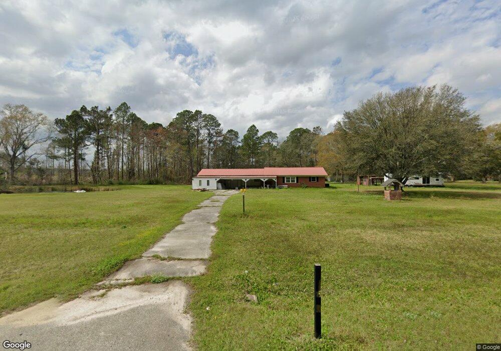
13819 Highway 41 Sparks, GA 31647
Estimated Value: $83,000 - $119,991
2
Beds
2
Baths
1,410
Sq Ft
$75/Sq Ft
Est. Value
About This Home
This home is located at 13819 Highway 41, Sparks, GA 31647 and is currently estimated at $105,498, approximately $74 per square foot. 13819 Highway 41 is a home located in Cook County with nearby schools including Cook Primary School, Cook Elementary School, and Cook County Middle School.
Ownership History
Date
Name
Owned For
Owner Type
Purchase Details
Closed on
Mar 17, 2015
Sold by
Sec Of Housing & U
Bought by
Joyell Kayla
Current Estimated Value
Purchase Details
Closed on
Apr 1, 2014
Sold by
Lakeview Loan Servicing Ll
Bought by
Sec Of Housing & Urban
Purchase Details
Closed on
Jul 1, 2009
Sold by
Coates Janie M
Bought by
Porter David A and Porter Christina
Home Financials for this Owner
Home Financials are based on the most recent Mortgage that was taken out on this home.
Original Mortgage
$93,610
Interest Rate
4.79%
Mortgage Type
FHA
Create a Home Valuation Report for This Property
The Home Valuation Report is an in-depth analysis detailing your home's value as well as a comparison with similar homes in the area
Home Values in the Area
Average Home Value in this Area
Purchase History
| Date | Buyer | Sale Price | Title Company |
|---|---|---|---|
| Joyell Kayla | $33,000 | -- | |
| Sec Of Housing & Urban | $97,646 | -- | |
| Lakeview Loan Servicing Llc | $97,646 | -- | |
| Porter David A | $115,000 | -- |
Source: Public Records
Mortgage History
| Date | Status | Borrower | Loan Amount |
|---|---|---|---|
| Previous Owner | Porter David A | $93,610 |
Source: Public Records
Tax History Compared to Growth
Tax History
| Year | Tax Paid | Tax Assessment Tax Assessment Total Assessment is a certain percentage of the fair market value that is determined by local assessors to be the total taxable value of land and additions on the property. | Land | Improvement |
|---|---|---|---|---|
| 2024 | $565 | $20,988 | $4,438 | $16,550 |
| 2023 | $462 | $19,159 | $4,438 | $14,721 |
| 2022 | $449 | $18,683 | $3,962 | $14,721 |
| 2021 | $425 | $16,642 | $3,962 | $12,680 |
| 2020 | $425 | $16,642 | $3,962 | $12,680 |
| 2019 | $425 | $16,642 | $3,962 | $12,680 |
| 2018 | $481 | $16,642 | $3,962 | $12,680 |
| 2017 | $481 | $16,642 | $3,962 | $12,680 |
| 2016 | $382 | $32,865 | $8,316 | $24,549 |
| 2015 | $954 | $32,865 | $8,316 | $24,549 |
| 2014 | $899 | $32,865 | $8,316 | $24,549 |
| 2013 | -- | $32,865 | $8,316 | $24,548 |
Source: Public Records
Map
Nearby Homes
- 15150 U S 41
- 0 Barneyville Rd
- 801 Broad St
- 103 N College St
- 411 S Robinson St
- 83 W Gray Ave
- 284 Barrett Rd
- 77 S Bobby St
- 134 Brandy Ct
- 320 E Central Ave
- 105 Orchard Cir
- 221 Rentz Bridge Rd
- 2603 Dianne St
- 2503 Dianne St
- 2302 Thomas St
- 123 Westover Dr
- 4711 Highway 37
- 120 Westover Dr
- 1402 Bear Creek Rd
- 1306 Bear Creek Rd
- 13889 Highway 41
- 140 Graves Ln
- 4145 Barneyville Rd
- 13680 Highway 41
- 14015 Highway 41
- 4150 Barneyville Rd
- 14051 Highway 41
- 270 Graves Ln
- 240 Maple Ln
- TBD Barneyville Srv Rd
- 3808 Barneyville Rd
- 4829 Barneyville Rd
- 4875 Barneyville Rd
- 4949 Barneyville Rd
- 0 Julian Joiner Rd Unit 195046
- 137 Rt 1 Box
- 5001 Barneyville Rd
- 3560 Barneyville Rd
- 77 Taylor Crosby Ln
- 35 Taylor Crosby Ln