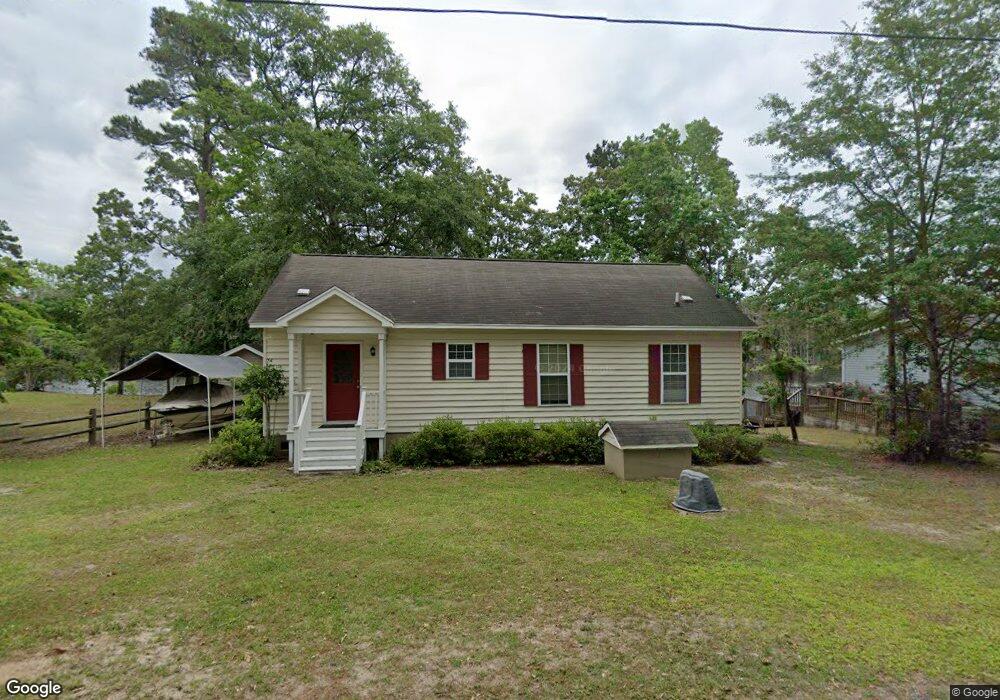
1382 Bayview Dr Manning, SC 29102
Estimated Value: $250,067 - $290,000
3
Beds
2
Baths
1,180
Sq Ft
$233/Sq Ft
Est. Value
About This Home
This home is located at 1382 Bayview Dr, Manning, SC 29102 and is currently estimated at $275,517, approximately $233 per square foot. 1382 Bayview Dr is a home located in Clarendon County.
Ownership History
Date
Name
Owned For
Owner Type
Purchase Details
Closed on
Nov 20, 2025
Sold by
Dorich Kathleen and Dorich Andrew
Bought by
Mcmanus William
Current Estimated Value
Purchase Details
Closed on
Jul 24, 2009
Sold by
Lesemann John D and Lesemann Linda M
Bought by
Dorich Andrew and Dorich Kathleen
Home Financials for this Owner
Home Financials are based on the most recent Mortgage that was taken out on this home.
Original Mortgage
$200,000
Interest Rate
5.53%
Mortgage Type
New Conventional
Create a Home Valuation Report for This Property
The Home Valuation Report is an in-depth analysis detailing your home's value as well as a comparison with similar homes in the area
Home Values in the Area
Average Home Value in this Area
Purchase History
| Date | Buyer | Sale Price | Title Company |
|---|---|---|---|
| Mcmanus William | $290,000 | None Listed On Document | |
| Dorich Andrew | $250,000 | None Available |
Source: Public Records
Mortgage History
| Date | Status | Borrower | Loan Amount |
|---|---|---|---|
| Previous Owner | Dorich Andrew | $200,000 |
Source: Public Records
Tax History
| Year | Tax Paid | Tax Assessment Tax Assessment Total Assessment is a certain percentage of the fair market value that is determined by local assessors to be the total taxable value of land and additions on the property. | Land | Improvement |
|---|---|---|---|---|
| 2025 | $2,955 | $7,404 | $3,259 | $4,145 |
| 2024 | $2,955 | $7,404 | $3,259 | $4,145 |
| 2023 | $2,878 | $7,404 | $3,259 | $4,145 |
| 2022 | $2,850 | $7,404 | $3,259 | $4,145 |
| 2021 | $2,239 | $6,438 | $2,400 | $4,038 |
| 2020 | $2,239 | $6,438 | $0 | $0 |
| 2019 | $2,144 | $6,438 | $0 | $0 |
| 2018 | $2,063 | $6,438 | $0 | $0 |
| 2017 | $2,057 | $6,438 | $0 | $0 |
| 2016 | $2,023 | $6,438 | $0 | $0 |
| 2015 | $2,168 | $6,996 | $2,700 | $4,296 |
| 2014 | $2,136 | $6,996 | $2,700 | $4,296 |
| 2013 | -- | $6,996 | $2,700 | $4,296 |
Source: Public Records
Map
Nearby Homes
- 1435 Stukes Rd
- 1746 Stukes Rd
- 00 Delano St
- Tbd Unit Sub
- 1303 Delano St
- 1205 Davis St
- 1519 Kenwood Rd
- 1343 Morello Rd
- 1016 Crawford Dr
- 5206 Cypress Pointe Unit D206
- 13348 S Carolina 260
- 13348 Hwy 260
- 1107 Cypress Pointe
- 1203 Cypress Pointe Unit A203
- 1702 Camp Shelor Rd
- 1580 Stillwater Dr
- 1527 Quail Trail
- 1824 Camp Shelor Dr
- 1083 Copperhead Rd
- 1583 Wyboo Ave
- 1378 Bayview Dr
- 1406 Bayview Dr
- 1430 Bayview Dr
- 1286 Bayview Dr
- 1470 Bayview Dr
- 1488 Bayview Dr
- 1283 Bayview Dr
- 1262 Bayview Dr
- 2100 Stukes Rd
- 1498 Bayview Dr
- 2074 Stukes Rd
- 1246 Bayview Dr
- 2092 Stukes Rd
- 2110 Stukes Rd
- 2066 Stukes Rd
- 2110 Stukes Rd
- 1070 Coffey St
- 1052 Coffey St
- 1241 Bayview Dr
- 2060 Stukes Rd
Your Personal Tour Guide
Ask me questions while you tour the home.