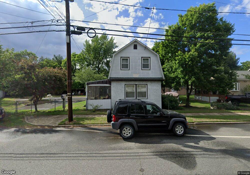
1382 Crown Point Rd West Deptford, NJ 08093
West Deptford Township NeighborhoodEstimated Value: $278,000 - $362,000
--
Bed
--
Bath
1,328
Sq Ft
$229/Sq Ft
Est. Value
About This Home
This home is located at 1382 Crown Point Rd, West Deptford, NJ 08093 and is currently estimated at $304,531, approximately $229 per square foot. 1382 Crown Point Rd is a home located in Gloucester County with nearby schools including Oakview Elementary School, Red Bank Elementary School, and Green-Fields Elementary School.
Ownership History
Date
Name
Owned For
Owner Type
Purchase Details
Closed on
Aug 28, 2019
Sold by
Kozarski Sherry L and Estate Of Richard J Carns Sr
Bought by
Kozarski Sherry L
Current Estimated Value
Purchase Details
Closed on
Mar 30, 2001
Sold by
Maiese Dominic L and Maiese Joann M
Bought by
Carns Richard J
Home Financials for this Owner
Home Financials are based on the most recent Mortgage that was taken out on this home.
Original Mortgage
$83,500
Outstanding Balance
$30,667
Interest Rate
6.97%
Mortgage Type
FHA
Estimated Equity
$273,864
Purchase Details
Closed on
May 10, 1999
Sold by
Costroff Kimberly Annyost and Costroff Andrew
Bought by
Maiese Dominic L and Maiese Joann M
Home Financials for this Owner
Home Financials are based on the most recent Mortgage that was taken out on this home.
Original Mortgage
$62,000
Interest Rate
6.92%
Purchase Details
Closed on
Sep 22, 1997
Sold by
Yost Kimberly Ann and Yost Jon F
Bought by
Yost Kimberly Ann
Create a Home Valuation Report for This Property
The Home Valuation Report is an in-depth analysis detailing your home's value as well as a comparison with similar homes in the area
Home Values in the Area
Average Home Value in this Area
Purchase History
| Date | Buyer | Sale Price | Title Company |
|---|---|---|---|
| Kozarski Sherry L | -- | None Available | |
| Carns Richard J | $84,900 | -- | |
| Maiese Dominic L | $35,882 | -- | |
| Yost Kimberly Ann | -- | -- |
Source: Public Records
Mortgage History
| Date | Status | Borrower | Loan Amount |
|---|---|---|---|
| Open | Carns Richard J | $83,500 | |
| Previous Owner | Maiese Dominic L | $62,000 |
Source: Public Records
Tax History Compared to Growth
Tax History
| Year | Tax Paid | Tax Assessment Tax Assessment Total Assessment is a certain percentage of the fair market value that is determined by local assessors to be the total taxable value of land and additions on the property. | Land | Improvement |
|---|---|---|---|---|
| 2025 | $4,410 | $126,300 | $36,600 | $89,700 |
| 2024 | $4,354 | $126,300 | $36,600 | $89,700 |
| 2023 | $4,354 | $126,300 | $36,600 | $89,700 |
| 2022 | $4,333 | $126,300 | $36,600 | $89,700 |
| 2021 | $4,318 | $126,300 | $36,600 | $89,700 |
| 2020 | $4,308 | $126,300 | $36,600 | $89,700 |
| 2019 | $4,188 | $126,300 | $36,600 | $89,700 |
| 2018 | $4,074 | $126,300 | $36,600 | $89,700 |
| 2017 | $3,980 | $126,300 | $36,600 | $89,700 |
| 2016 | $3,869 | $126,300 | $36,600 | $89,700 |
| 2015 | $3,831 | $131,300 | $41,600 | $89,700 |
| 2014 | $3,641 | $131,300 | $41,600 | $89,700 |
Source: Public Records
Map
Nearby Homes
- 1359 Crown Point Rd
- 1372 Riley Ave
- 1346 Verga Ave
- 1009 Hessian Ave
- 1174 Harker Ave
- 1134 Brewer Ave
- 1185 Lawnton Ave
- 1156 Hessian Ave
- 182 Covington Ln
- 815 Harker Ave
- 210 Lawnton Ave
- 1234 Lincoln Ave
- 575 Lawnton Ave
- 1416 Cleveland Ave
- 57 Hessian Ave
- 112 Progress Ave
- 1337 Lincoln Ave
- 845 W Red Bank Ave
- 125 Crescent Ave
- 121 Crescent Ave
- 1374 Crown Point Rd
- 1396 Crown Point Rd
- 1370 Crown Point Rd
- 1391 Crown Point Rd
- 1400 Crown Point Rd
- 1395 Crown Point Rd
- 987 Mail Ave
- 1377 Crown Point Rd
- 1368 Crown Point Rd
- 1371 Crown Point Rd
- 1399 Crown Point Rd
- 1406 Crown Point Rd
- 1369 Crown Point Rd
- 1403 Crown Point Rd
- 1363 Crown Point Rd
- 974 Mail Ave
- 1372 Verga Ave
- 1378 Verga Ave
- 1051 Frontage Ave
- 977 Hessian Ave