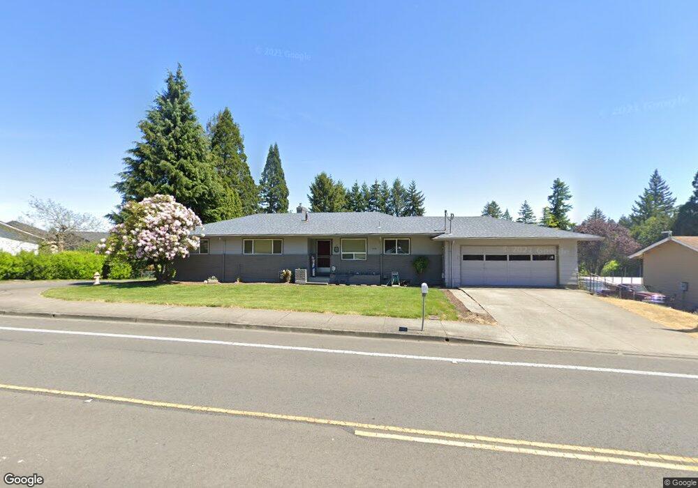
13830 SW 121st Ave Portland, OR 97223
Derry Dell NeighborhoodEstimated Value: $587,000 - $687,000
5
Beds
3
Baths
2,536
Sq Ft
$255/Sq Ft
Est. Value
About This Home
This home is located at 13830 SW 121st Ave, Portland, OR 97223 and is currently estimated at $647,489, approximately $255 per square foot. 13830 SW 121st Ave is a home located in Washington County with nearby schools including Charles F. Tigard Elementary School, Thomas R. Fowler Middle School, and Tigard High School.
Ownership History
Date
Name
Owned For
Owner Type
Purchase Details
Closed on
Jan 13, 2022
Sold by
Monaghan Penny D
Bought by
James And Penny Monaghan Living Trust and Livin Penny
Current Estimated Value
Purchase Details
Closed on
May 9, 2012
Sold by
Roll Wayne J
Bought by
Monaghan Penny D and Monaghan James D
Home Financials for this Owner
Home Financials are based on the most recent Mortgage that was taken out on this home.
Original Mortgage
$209,549
Interest Rate
3.98%
Mortgage Type
FHA
Create a Home Valuation Report for This Property
The Home Valuation Report is an in-depth analysis detailing your home's value as well as a comparison with similar homes in the area
Home Values in the Area
Average Home Value in this Area
Purchase History
| Date | Buyer | Sale Price | Title Company |
|---|---|---|---|
| James And Penny Monaghan Living Trust | $81,000 | None Listed On Document | |
| Monaghan Penny D | $215,000 | Ticor Title Company |
Source: Public Records
Mortgage History
| Date | Status | Borrower | Loan Amount |
|---|---|---|---|
| Previous Owner | Monaghan Penny D | $209,549 |
Source: Public Records
Tax History Compared to Growth
Tax History
| Year | Tax Paid | Tax Assessment Tax Assessment Total Assessment is a certain percentage of the fair market value that is determined by local assessors to be the total taxable value of land and additions on the property. | Land | Improvement |
|---|---|---|---|---|
| 2025 | $6,796 | $398,590 | -- | -- |
| 2024 | $6,613 | $386,990 | -- | -- |
| 2023 | $6,613 | $375,720 | $0 | $0 |
| 2022 | $6,423 | $375,720 | $0 | $0 |
| 2021 | $6,262 | $354,160 | $0 | $0 |
| 2020 | $6,074 | $343,850 | $0 | $0 |
| 2019 | $5,811 | $333,840 | $0 | $0 |
| 2018 | $5,576 | $324,120 | $0 | $0 |
| 2017 | $5,102 | $298,730 | $0 | $0 |
| 2016 | $4,871 | $290,030 | $0 | $0 |
| 2015 | $4,682 | $281,590 | $0 | $0 |
| 2014 | $4,542 | $273,390 | $0 | $0 |
Source: Public Records
Map
Nearby Homes
- 12183 SW Plantation Terrace
- 13953 SW Aerie Dr
- 12176 SW Ames Ln
- 12174 SW Quail Creek Ln
- 13890 SW 118th Ct
- 11735 SW Gaarde St
- 13610 SW Aerie Dr
- 14170 SW 119th Place
- 12357 SW Duchilly Ct
- 12249 SW Hollow Ln
- 12009 SW Wildwood St
- 11975 SW Wildwood St
- 12822 SW Morningstar Dr
- 13728 SW 130th Place
- 13154 SW 121st Ave
- 13085 SW 124th Ave
- 13236 SW Bigleaf Dr
- 13001 SW Gallin Ct
- 12175 SW Alberta St
- 13123 SW Merlin Place
- 13825 SW 121st Ave
- 13870 SW 121st Ave
- 12125 SW Plantation Terrace
- 13770 SW 122nd Ave
- 12130 SW Kelly Ln
- 13760 SW 121st Ave
- 13910 SW 121st Ave
- 12000 SW Rose Vista Dr
- 12207 SW Plantation Terrace
- 13984 SW Aerie Dr
- 12075 SW Rose Vista Dr
- 11990 SW Rose Vista Dr
- 0 2s103cc00700 Unit 17657128
- 12170 SW Kelly Ln
- 13750 SW 122nd Ave
- 12084 SW Whistlers Loop
- 12259 SW Plantation Terrace
- 13972 SW Aerie Dr
- 12082 SW Whistlers Loop
- 13990 SW Aerie Dr