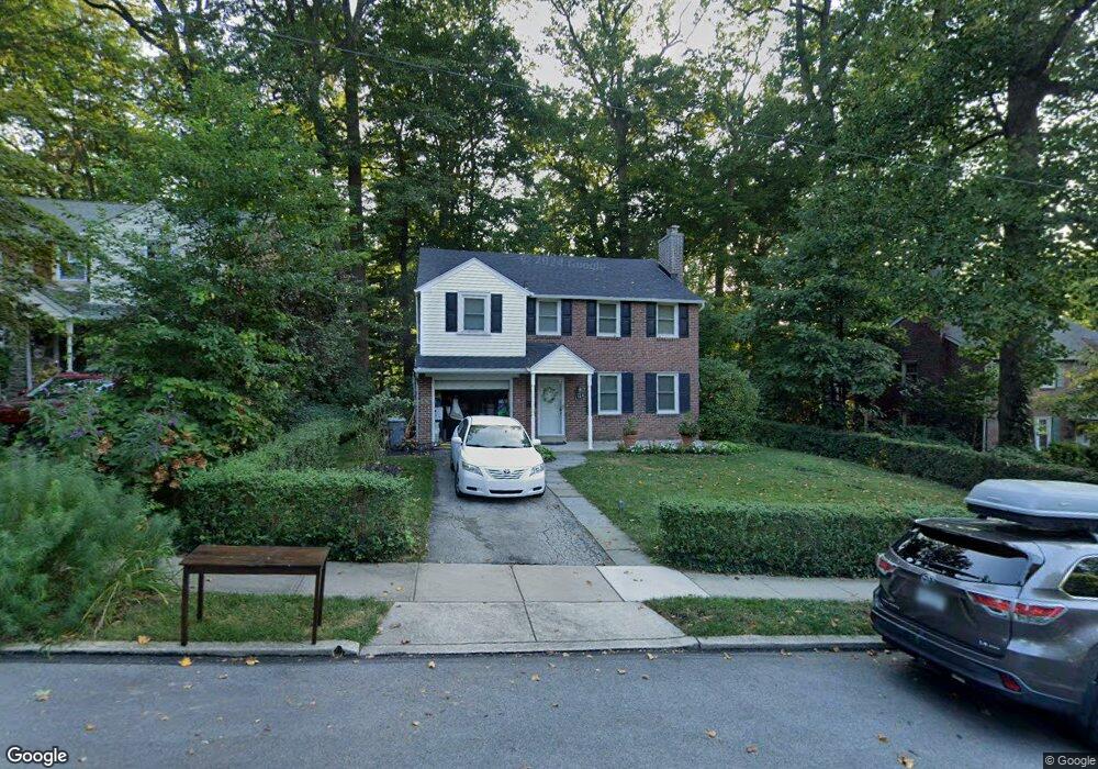
1384 Dermond Rd Drexel Hill, PA 19026
Estimated Value: $476,000 - $527,000
4
Beds
3
Baths
1,498
Sq Ft
$336/Sq Ft
Est. Value
About This Home
This home is located at 1384 Dermond Rd, Drexel Hill, PA 19026 and is currently estimated at $504,044, approximately $336 per square foot. 1384 Dermond Rd is a home located in Delaware County with nearby schools including Manoa Elementary School, Haverford Middle School, and Haverford Senior High School.
Ownership History
Date
Name
Owned For
Owner Type
Purchase Details
Closed on
Nov 23, 1999
Sold by
Thompson Ansel F and Thompson Irene T
Bought by
Freda Mark John and Freda Nicole
Current Estimated Value
Home Financials for this Owner
Home Financials are based on the most recent Mortgage that was taken out on this home.
Original Mortgage
$127,600
Interest Rate
7.73%
Create a Home Valuation Report for This Property
The Home Valuation Report is an in-depth analysis detailing your home's value as well as a comparison with similar homes in the area
Home Values in the Area
Average Home Value in this Area
Purchase History
| Date | Buyer | Sale Price | Title Company |
|---|---|---|---|
| Freda Mark John | $159,500 | T A Title Insurance Company |
Source: Public Records
Mortgage History
| Date | Status | Borrower | Loan Amount |
|---|---|---|---|
| Previous Owner | Freda Mark John | $127,600 |
Source: Public Records
Tax History Compared to Growth
Tax History
| Year | Tax Paid | Tax Assessment Tax Assessment Total Assessment is a certain percentage of the fair market value that is determined by local assessors to be the total taxable value of land and additions on the property. | Land | Improvement |
|---|---|---|---|---|
| 2025 | $8,000 | $311,150 | $100,870 | $210,280 |
| 2024 | $8,000 | $311,150 | $100,870 | $210,280 |
| 2023 | $7,773 | $311,150 | $100,870 | $210,280 |
| 2022 | $7,591 | $311,150 | $100,870 | $210,280 |
| 2021 | $12,367 | $311,150 | $100,870 | $210,280 |
| 2020 | $6,866 | $147,720 | $52,440 | $95,280 |
| 2019 | $6,739 | $147,720 | $52,440 | $95,280 |
| 2018 | $6,624 | $147,720 | $0 | $0 |
| 2017 | $6,483 | $147,720 | $0 | $0 |
| 2016 | $811 | $147,720 | $0 | $0 |
| 2015 | $811 | $147,720 | $0 | $0 |
| 2014 | $811 | $147,720 | $0 | $0 |
Source: Public Records
Map
Nearby Homes
- 181 Friendship Rd
- 736 Timber Trail Ln
- 505 Glendale Rd
- 104 Treaty Rd
- 5042 Sylvia Rd
- 5233 Arrowhead Ln
- 429 Portland Dr
- 414 Stanfield Rd
- 333 Sussex Blvd
- 416 Warren Blvd
- 530 Hempstead Rd
- 516 Portland Dr
- 412 N Rolling Rd
- 921 Addingham Ave
- 4938 State Rd
- 631 S Central Blvd
- 1042 Blythe Ave
- 920 Alexander Ave
- 1029 Belfield Ave
- 42 Colonial Dr
- 1388 Dermond Rd
- 1380 Dermond Rd
- 1392 Dermond Rd
- 1376 Dermond Rd
- 252 Flintlock Rd
- 257 Flintlock Rd
- 300 Warrior Rd
- 248 Flintlock Rd
- 248 Warrior Rd
- 253 Flintlock Rd
- 1368 Dermond Rd
- 249 Signal Rd
- 244 Flintlock Rd
- 249 Flintlock Rd
- 244 Warrior Rd
- 1364 Dermond Rd
- 245 Signal Rd
- 245 Flintlock Rd
- 240 Warrior Rd
- 240 Flintlock Rd