K
Seller's Agent in 2025
Kerry Oman
Summit Sotheby's International Realty
(801) 369-2507
1 in this area
131 Total Sales
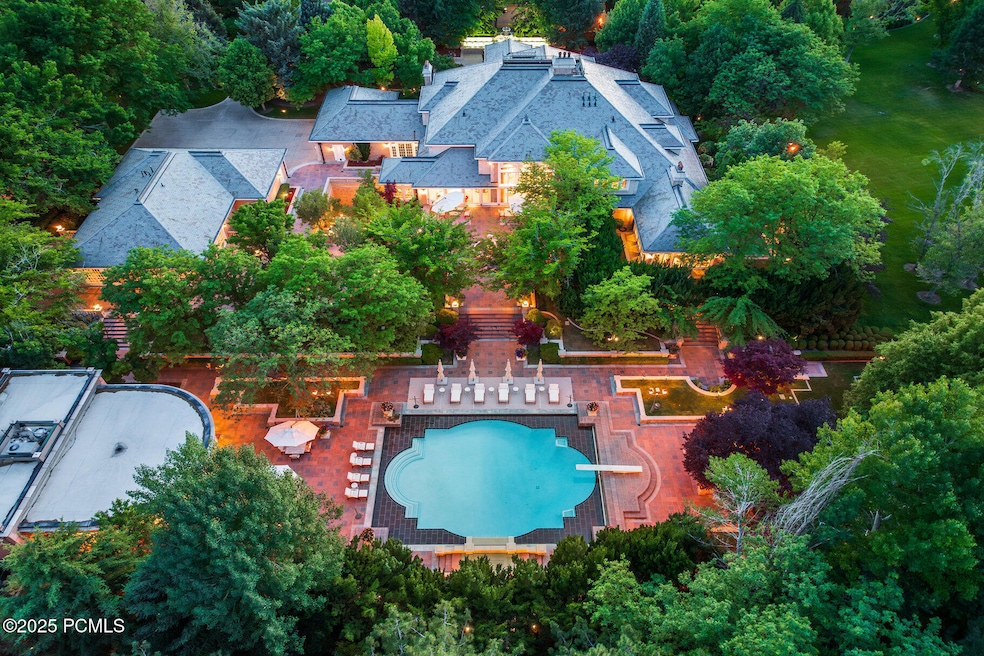
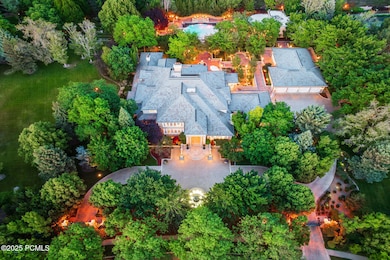
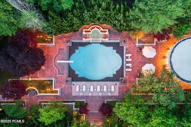
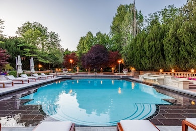
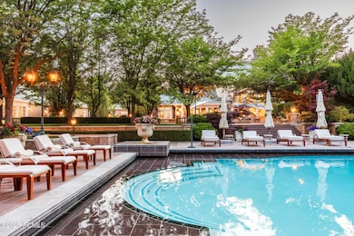
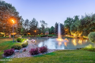
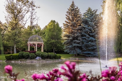
Hidden behind towering brick walls and a canopy of mature trees, this extraordinary estate offers the privacy, scale, and craftsmanship rarely found along the Wasatch Front. Situated on 7.73 gated acres and reminiscent of a European manor, the property was built by Magleby Construction to the highest standards and it includes nearly 25,000 square feet of living space. Every detail reflects timeless quality, from the grand architectural elements to the artisan millwork throughout. The main residence features nine bedrooms and thirteen bathrooms, along with expansive entertaining areas designed for large gatherings or refined everyday living. In addition to the main home, there is an artist's studio with a lower-level apartment and a large RV garage with attached office and storage. The outdoor spaces are equally exceptional, anchored by a 38' x 54' saltwater swimming pool with expansive decks, an integrated hot tub, sculptural fountains, and a beautifully appointed pool house ideal for entertaining. The grounds also include a private pond, manicured gardens, multiple fountains, a tennis court, racquetball court, and vast lawns that feel more like a private park than a residence. The land is composed of five individually platted lots, offering rare flexibility for future development, guest homes, or potential resale. Priced significantly below cost, this is a rare opportunity to own one of Utah's most private and iconic luxury estates.
Last Agent to Sell the Property
Summit Sotheby's International Realty License #5459867-AB00 Listed on: 06/17/2025

Last Buyer's Agent
Non Member Licensee
Non Member
| Date | Type | Sale Price | Title Company |
|---|---|---|---|
| Warranty Deed | -- | Real Advantage Title | |
| Warranty Deed | -- | First American Title Insurance | |
| Special Warranty Deed | -- | Alta Title Insurance Agency | |
| Warranty Deed | -- | -- |
| Date | Status | Loan Amount | Loan Type |
|---|---|---|---|
| Open | $6,300,000 | Seller Take Back | |
| Closed | $2,428,837 | New Conventional | |
| Previous Owner | $999,999 | Seller Take Back |
| Date | Event | Price | List to Sale | Price per Sq Ft |
|---|---|---|---|---|
| 11/18/2025 11/18/25 | Sold | -- | -- | -- |
| 07/19/2025 07/19/25 | Pending | -- | -- | -- |
| 06/17/2025 06/17/25 | For Sale | $15,000,000 | -- | $605 / Sq Ft |
| Year | Tax Paid | Tax Assessment Tax Assessment Total Assessment is a certain percentage of the fair market value that is determined by local assessors to be the total taxable value of land and additions on the property. | Land | Improvement |
|---|---|---|---|---|
| 2025 | $30,475 | $3,505,940 | -- | -- |
| 2024 | $30,475 | $3,726,420 | $0 | $0 |
| 2023 | $30,138 | $3,960,830 | $0 | $0 |
| 2022 | $36,123 | $7,990,600 | $949,400 | $7,041,200 |
| 2021 | $34,341 | $6,436,700 | $677,200 | $5,759,500 |
| 2020 | $34,649 | $6,436,700 | $677,200 | $5,759,500 |
| 2019 | $30,122 | $5,751,000 | $677,200 | $5,073,800 |
| 2018 | $2,518 | $5,316,200 | $677,200 | $4,639,000 |
| 2017 | $26,699 | $2,693,345 | $0 | $0 |
| 2016 | $25,016 | $2,327,110 | $0 | $0 |
| 2015 | $26,452 | $2,327,110 | $0 | $0 |
| 2014 | $25,524 | $2,235,260 | $0 | $0 |
K
Seller's Agent in 2025
Kerry Oman
Summit Sotheby's International Realty
(801) 369-2507
1 in this area
131 Total Sales
N
Buyer's Agent in 2025
Non Member Licensee
Non Member
Source: Park City Board of REALTORS®
MLS Number: 12502709
APN: 48-088-0001
Disclaimer: Certain information contained herein is derived from information provided by parties other than Homes.com. All information provided is deemed reliable, but is not guaranteed to be accurate and should be independently verified.
![]() This information is provided exclusively for consumers’ personal, non-commercial use, and it may not be used for any purpose other than to identify prospective properties consumers may be interested in purchasing. This data is deemed reliable but is not guaranteed accurate by the MLS.
This information is provided exclusively for consumers’ personal, non-commercial use, and it may not be used for any purpose other than to identify prospective properties consumers may be interested in purchasing. This data is deemed reliable but is not guaranteed accurate by the MLS.
The multiple listing information is provided by Park City Board of REALTORS® from a copyrighted compilation of listings. The compilation of listings and each individual listing are © 2026 Park City Board of REALTORS®, All Rights Reserved. Access to the multiple listing information through this website is made available by Ten-X as a member of the Park City Board of REALTORS® multiple listing service.
Ask me questions while you tour the home.