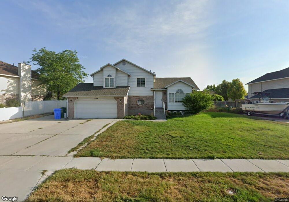
1384 W Quail Ridge Cir Riverton, UT 84065
Estimated Value: $503,000 - $599,000
4
Beds
3
Baths
2,285
Sq Ft
$250/Sq Ft
Est. Value
About This Home
This home is located at 1384 W Quail Ridge Cir, Riverton, UT 84065 and is currently estimated at $570,639, approximately $249 per square foot. 1384 W Quail Ridge Cir is a home located in Salt Lake County with nearby schools including Rosamond Elementary School, Oquirrh Hills Middle School, and Riverton High School.
Ownership History
Date
Name
Owned For
Owner Type
Purchase Details
Closed on
May 8, 2025
Sold by
Ohappy Day Inc
Bought by
Pink Day Llc
Current Estimated Value
Purchase Details
Closed on
Jan 31, 2019
Sold by
Johnson Joshua
Bought by
O Happy Day Inc
Home Financials for this Owner
Home Financials are based on the most recent Mortgage that was taken out on this home.
Original Mortgage
$216,000
Interest Rate
4.6%
Mortgage Type
New Conventional
Purchase Details
Closed on
Nov 19, 2018
Sold by
Tallakson Bart H
Bought by
O Happy Day Inc
Purchase Details
Closed on
Jul 7, 2015
Sold by
Anderson Justin S and Anderson Amanda L
Bought by
Tallakson Bart
Home Financials for this Owner
Home Financials are based on the most recent Mortgage that was taken out on this home.
Original Mortgage
$260,200
Interest Rate
3.87%
Mortgage Type
FHA
Purchase Details
Closed on
Sep 22, 2004
Sold by
Anderson Justin Scott and Anderson Amanda Lee
Bought by
Anderson Justin S and Anderson Amanda L
Home Financials for this Owner
Home Financials are based on the most recent Mortgage that was taken out on this home.
Original Mortgage
$157,000
Interest Rate
5.62%
Mortgage Type
New Conventional
Purchase Details
Closed on
Sep 16, 2004
Sold by
Stone David and Stone Leslie
Bought by
Anderson Justin Scott and Anderson Amanda Lee
Home Financials for this Owner
Home Financials are based on the most recent Mortgage that was taken out on this home.
Original Mortgage
$157,000
Interest Rate
5.62%
Mortgage Type
New Conventional
Purchase Details
Closed on
Jul 30, 2003
Sold by
Bass Paul P and Bass Teresa H
Bought by
Stone David and Stone Leslie
Home Financials for this Owner
Home Financials are based on the most recent Mortgage that was taken out on this home.
Original Mortgage
$167,500
Interest Rate
5.17%
Mortgage Type
Seller Take Back
Create a Home Valuation Report for This Property
The Home Valuation Report is an in-depth analysis detailing your home's value as well as a comparison with similar homes in the area
Home Values in the Area
Average Home Value in this Area
Purchase History
| Date | Buyer | Sale Price | Title Company |
|---|---|---|---|
| Pink Day Llc | -- | -- | |
| Pink Day Llc | -- | -- | |
| O Happy Day Inc | -- | Capstone Title & Escrow | |
| Johnson Joshua | -- | Capstone Title & Escrow | |
| O Happy Day Inc | -- | Capstone Title & Escrow | |
| Tallakson Bart | -- | Title Guarantee | |
| Anderson Justin S | -- | Cottonwood Title Ins Agency | |
| Anderson Justin Scott | -- | Inwest Title Services | |
| Stone David | -- | Meridian Title |
Source: Public Records
Mortgage History
| Date | Status | Borrower | Loan Amount |
|---|---|---|---|
| Previous Owner | Johnson Joshua | $216,000 | |
| Previous Owner | Tallakson Bart | $260,200 | |
| Previous Owner | Anderson Justin S | $157,000 | |
| Previous Owner | Anderson Justin Scott | $152,800 | |
| Previous Owner | Stone David | $167,500 | |
| Closed | Stone David | $174,000 | |
| Closed | Anderson Justin Scott | $38,200 |
Source: Public Records
Tax History Compared to Growth
Tax History
| Year | Tax Paid | Tax Assessment Tax Assessment Total Assessment is a certain percentage of the fair market value that is determined by local assessors to be the total taxable value of land and additions on the property. | Land | Improvement |
|---|---|---|---|---|
| 2025 | $2,980 | $524,700 | $202,000 | $322,700 |
| 2024 | $2,980 | $515,800 | $198,300 | $317,500 |
| 2023 | $2,980 | $471,600 | $183,600 | $288,000 |
| 2022 | $3,168 | $483,800 | $180,000 | $303,800 |
| 2021 | $2,860 | $371,500 | $135,000 | $236,500 |
| 2020 | $2,440 | $324,200 | $121,000 | $203,200 |
| 2019 | $2,798 | $320,100 | $110,000 | $210,100 |
| 2018 | $2,543 | $298,300 | $110,000 | $188,300 |
| 2017 | $2,190 | $274,500 | $110,000 | $164,500 |
| 2016 | $2,129 | $256,100 | $102,000 | $154,100 |
| 2015 | $2,030 | $236,700 | $103,800 | $132,900 |
| 2014 | -- | $222,700 | $98,900 | $123,800 |
Source: Public Records
Map
Nearby Homes
- 1371 W Stewart Falls Dr
- 1373 W Stewart Falls Dr
- 12392 S 1300 W
- 1233 W 12500 S
- 12294 S 1490 W
- 12566 S Tithing Hill Dr
- 1056 W Kate Springs Ln S Unit 10
- 12216 S 1300 W
- 1273 W Hendrix St Unit 145
- 1269 W Hendrix St Unit 146
- 1259 W Moon Way Unit 134
- 1560 W 12730 S
- 12345 S Redwood Rd
- 1410 W 12115 S
- 12325 S Redwood Rd
- 12317 S Redwood Rd
- 1184 W Margaret Rose Dr
- 12091 S Lampton View Dr
- 12952 S Croix Cir
- 1182 River Hills Dr
- 1384 Quail Ridge Cir
- 1372 Quail Ridge Cir
- 1396 Quail Ridge Cir
- 1395 Quail Covey Cir
- 1411 Quail Covey Cir
- 1387 Quail Ridge Cir
- 1375 W Quail Ridge Cir
- 1399 Quail Ridge Cir
- 1375 Quail Ridge Cir
- 1399 W Quail Ridge Cir
- 1414 Quail Ridge Cir
- 1414 W Quail Ridge Cir
- 1367 W Quail Covey Cir
- 1367 Quail Covey Cir
- 1421 Quail Covey Cir
- 12456 Covey Ln
- 1421 W Quail Covey Cir
- 1421 Quail Ridge Cir
- 1417 Quail Ridge Cir
- 1388 Quail Covey Cir