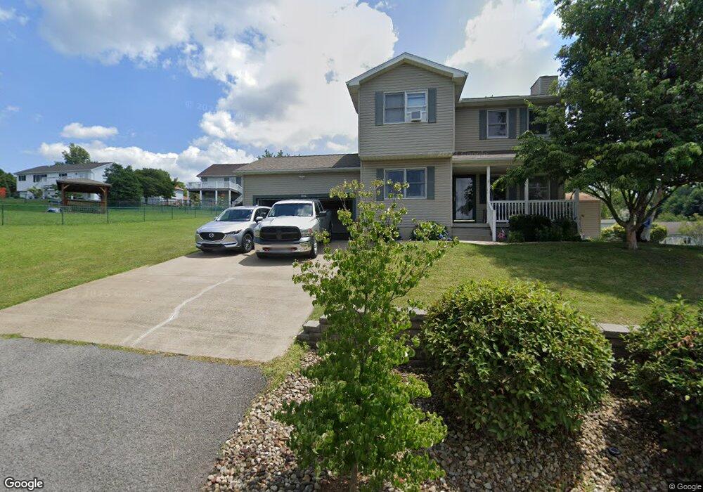
1386 Bennett Dr Morgantown, WV 26508
Brookhaven NeighborhoodEstimated Value: $314,000 - $347,294
3
Beds
3
Baths
1,870
Sq Ft
$181/Sq Ft
Est. Value
About This Home
This home is located at 1386 Bennett Dr, Morgantown, WV 26508 and is currently estimated at $338,574, approximately $181 per square foot. 1386 Bennett Dr is a home located in Monongalia County with nearby schools including Brookhaven Elementary School, South Middle School, and Morgantown High School.
Ownership History
Date
Name
Owned For
Owner Type
Purchase Details
Closed on
Dec 9, 2019
Sold by
Ours Reggie A and Ours Christine M
Bought by
Hakkoum Sara and Makdsi Layla
Current Estimated Value
Home Financials for this Owner
Home Financials are based on the most recent Mortgage that was taken out on this home.
Original Mortgage
$181,600
Outstanding Balance
$160,419
Interest Rate
3.7%
Mortgage Type
New Conventional
Estimated Equity
$178,155
Create a Home Valuation Report for This Property
The Home Valuation Report is an in-depth analysis detailing your home's value as well as a comparison with similar homes in the area
Home Values in the Area
Average Home Value in this Area
Purchase History
| Date | Buyer | Sale Price | Title Company |
|---|---|---|---|
| Hakkoum Sara | $227,000 | None Available |
Source: Public Records
Mortgage History
| Date | Status | Borrower | Loan Amount |
|---|---|---|---|
| Open | Hakkoum Sara | $181,600 |
Source: Public Records
Tax History Compared to Growth
Tax History
| Year | Tax Paid | Tax Assessment Tax Assessment Total Assessment is a certain percentage of the fair market value that is determined by local assessors to be the total taxable value of land and additions on the property. | Land | Improvement |
|---|---|---|---|---|
| 2024 | $1,473 | $132,360 | $35,580 | $96,780 |
| 2023 | $1,410 | $132,360 | $35,580 | $96,780 |
| 2022 | $1,349 | $131,640 | $35,580 | $96,060 |
| 2021 | $1,207 | $117,180 | $35,580 | $81,600 |
| 2020 | $1,212 | $117,180 | $35,580 | $81,600 |
| 2019 | $1,230 | $118,080 | $35,580 | $82,500 |
| 2018 | $1,235 | $118,140 | $35,580 | $82,560 |
| 2017 | $1,229 | $117,000 | $33,540 | $83,460 |
| 2016 | $1,210 | $114,420 | $30,900 | $83,520 |
| 2015 | $1,142 | $112,980 | $28,560 | $84,420 |
| 2014 | $1,043 | $108,120 | $26,280 | $81,840 |
Source: Public Records
Map
Nearby Homes
- 304 Salonika Dr
- 36 Dellslow Ln
- 205 Pixler Hill Rd
- B7-R Meadowland Dr
- B-5R Meadowland Dr
- N-2 Lemley St
- N-1 Lemley St
- Lot 6 Ices Ferry Estates
- 116 Corkrean Way
- 374 Brookhaven Rd
- 000 Bowers Ln
- 142 Vecchio Ln
- 118 Park Place Dr
- 3110 Sylvan Dr
- 210 Josephine Dr
- 207 Josephine Dr
- 109 Trevilla Ave
- 3392 Earl L Core Rd
- 16 Reyes Ln
- Lot 8 Brookdale Dr
- 1384 Bennett Dr
- 1085 Brookings Dr
- 1087 Brookings Dr
- 1385 Bennett Dr
- 1387 Bennett Dr
- 1083 Brookings Dr
- 1091 Brookings Dr
- 1383 Bennett Dr
- 1390 Bennett Dr
- 1389 Bennett Dr
- 1407 Brockton Dr
- 1409 Brockton Dr
- 1381 Bennett Dr
- 1379 Bennett Dr
- 1405 Brockton Dr
- 1090 Brookings Dr
- 1093 Brookings Dr
- 1086 Brookings Dr
- 1391 Bennett Dr
- 1392 Bennett Dr