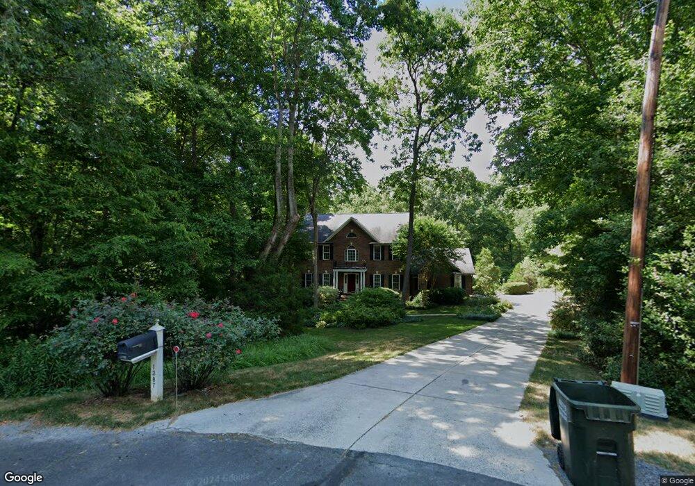
1387 Mcdaniel Dr Asheboro, NC 27205
Estimated Value: $501,690 - $573,000
--
Bed
3
Baths
2,706
Sq Ft
$195/Sq Ft
Est. Value
About This Home
This home is located at 1387 Mcdaniel Dr, Asheboro, NC 27205 and is currently estimated at $527,673, approximately $195 per square foot. 1387 Mcdaniel Dr is a home located in Randolph County with nearby schools including Sycamore Elementary School, Farmer Elementary School, and Uwharrie Ridge Six-Twelve.
Ownership History
Date
Name
Owned For
Owner Type
Purchase Details
Closed on
May 29, 2007
Sold by
Peraldo Leo L and Peraldo Amy P
Bought by
Miller David E and Miller Rebecca R
Current Estimated Value
Home Financials for this Owner
Home Financials are based on the most recent Mortgage that was taken out on this home.
Original Mortgage
$283,500
Outstanding Balance
$171,973
Interest Rate
6.12%
Mortgage Type
Purchase Money Mortgage
Estimated Equity
$355,700
Purchase Details
Closed on
Feb 9, 2001
Bought by
Miller David E Miller Rebecca R
Create a Home Valuation Report for This Property
The Home Valuation Report is an in-depth analysis detailing your home's value as well as a comparison with similar homes in the area
Home Values in the Area
Average Home Value in this Area
Purchase History
| Date | Buyer | Sale Price | Title Company |
|---|---|---|---|
| Miller David E | $315,000 | None Available | |
| Miller David E Miller Rebecca R | $266,500 | -- |
Source: Public Records
Mortgage History
| Date | Status | Borrower | Loan Amount |
|---|---|---|---|
| Open | Miller David E | $283,500 |
Source: Public Records
Tax History Compared to Growth
Tax History
| Year | Tax Paid | Tax Assessment Tax Assessment Total Assessment is a certain percentage of the fair market value that is determined by local assessors to be the total taxable value of land and additions on the property. | Land | Improvement |
|---|---|---|---|---|
| 2025 | $2,598 | $393,700 | $59,220 | $334,480 |
| 2024 | $2,559 | $393,700 | $59,220 | $334,480 |
| 2023 | $2,559 | $393,700 | $59,220 | $334,480 |
| 2022 | $2,213 | $282,740 | $42,830 | $239,910 |
| 2021 | $2,213 | $282,740 | $42,830 | $239,910 |
| 2020 | $2,156 | $282,740 | $42,830 | $239,910 |
| 2019 | $2,156 | $282,740 | $42,830 | $239,910 |
| 2018 | $1,915 | $244,780 | $40,500 | $204,280 |
| 2016 | $1,891 | $244,782 | $40,500 | $204,282 |
| 2015 | $1,873 | $244,782 | $40,500 | $204,282 |
| 2014 | $1,856 | $244,782 | $40,500 | $204,282 |
Source: Public Records
Map
Nearby Homes
- 0 Nc Highway 49 S Unit 1162269
- 1559 Allen Ct
- 2442 Farmwood Ln
- 2209 Cedarwood Ct
- 1564 Walker Rd
- 1746 Taylors Creek Dr
- 1575 Leslie St
- 2318 Doul Mountain Rd
- 2272 Doul Mountain Rd
- 0 Muriel Ln
- 1301 Nc Highway 49 S
- 00 U S Highway 64
- 1669 Moore Rd
- 0 Danny Bell Rd
- 2634 Fox Ridge Rd
- 2626 Fox Ridge Rd
- 0 Fox Ridge Rd Unit 1197775
- Lot 37 Fox Ridge Rd
- 0 Deer Ridge Rd Unit 1190677
- 0 Deer Ridge Rd Unit 1191444
- 1403 Mcdaniel Dr
- 1431 Richards Cir
- 1430 Mcdaniel Dr
- 1417 Richards Cir
- 1411 Mcdaniel Dr
- 1437 Richards Cir
- 1391 Mcdaniel Dr
- 1413 Richards Cir
- 1473 Richards Cir
- 1448 Mcdaniel Dr
- 1436 Richards Cir
- 1424 Richards Cir
- 1451 Mcdaniel Dr
- 1478 Richards Cir
- 1482 Richards Cir
- 1483 Mcdaniel Dr
- 0 Nc Highway 49 S Unit 1038862
- 0 Nc Highway 49 S Unit 513313
- 0 Nc Highway 49 S Unit 840344
- 0 Nc Highway 49 S Unit 893691