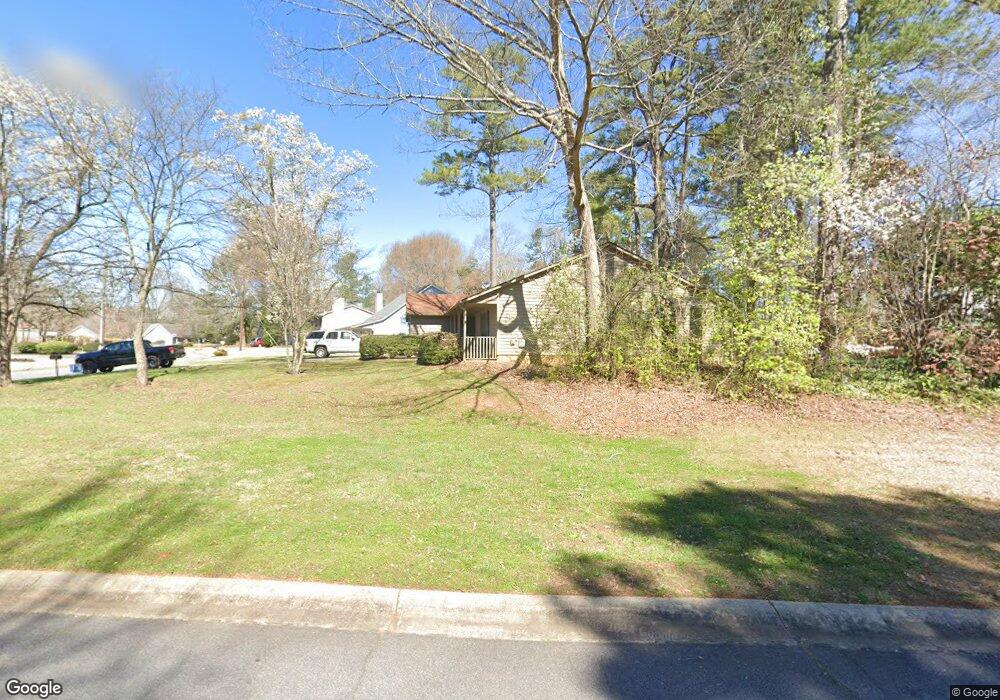
1387 Olde Mill Trace Unit 39 Woodstock, GA 30188
Estimated Value: $354,000 - $377,028
4
Beds
2
Baths
1,711
Sq Ft
$214/Sq Ft
Est. Value
About This Home
This home is located at 1387 Olde Mill Trace Unit 39, Woodstock, GA 30188 and is currently estimated at $365,514, approximately $213 per square foot. 1387 Olde Mill Trace Unit 39 is a home located in Cherokee County with nearby schools including Woodstock Elementary School, Woodstock Middle School, and Woodstock High School.
Ownership History
Date
Name
Owned For
Owner Type
Purchase Details
Closed on
Jan 31, 2014
Sold by
Srp Sub Llc
Bought by
Tarbert Llc
Current Estimated Value
Purchase Details
Closed on
Sep 26, 2013
Sold by
Lamborn Richard
Bought by
Srp Sub Llc
Purchase Details
Closed on
Jun 27, 1996
Sold by
Stephens Creig Fox Barbara
Bought by
Lamborn Richard Catheri and Lamborn Ne
Create a Home Valuation Report for This Property
The Home Valuation Report is an in-depth analysis detailing your home's value as well as a comparison with similar homes in the area
Home Values in the Area
Average Home Value in this Area
Purchase History
| Date | Buyer | Sale Price | Title Company |
|---|---|---|---|
| Tarbert Llc | -- | -- | |
| Srp Sub Llc | $120,000 | -- | |
| Lamborn Richard Catheri | $107,000 | -- |
Source: Public Records
Mortgage History
| Date | Status | Borrower | Loan Amount |
|---|---|---|---|
| Closed | Lamborn Richard Catheri | $0 |
Source: Public Records
Tax History Compared to Growth
Tax History
| Year | Tax Paid | Tax Assessment Tax Assessment Total Assessment is a certain percentage of the fair market value that is determined by local assessors to be the total taxable value of land and additions on the property. | Land | Improvement |
|---|---|---|---|---|
| 2025 | $3,210 | $122,252 | $31,600 | $90,652 |
| 2024 | $3,177 | $122,252 | $31,600 | $90,652 |
| 2023 | $3,177 | $122,252 | $31,600 | $90,652 |
| 2022 | $2,652 | $100,892 | $26,000 | $74,892 |
| 2021 | $2,358 | $83,052 | $18,000 | $65,052 |
| 2020 | $2,097 | $73,812 | $12,800 | $61,012 |
| 2019 | $1,866 | $65,680 | $12,800 | $52,880 |
| 2018 | $1,855 | $64,880 | $12,800 | $52,080 |
| 2017 | $1,755 | $152,300 | $12,800 | $48,120 |
| 2016 | $1,621 | $139,200 | $10,400 | $45,280 |
| 2015 | $1,516 | $128,900 | $10,400 | $41,160 |
| 2014 | $1,409 | $119,600 | $10,400 | $37,440 |
Source: Public Records
Map
Nearby Homes
- 1244 Hickory Wood Dr NE
- 4941 Willow Ln
- 421 Creek Valley Dr
- 4816 Olde Mill Dr
- 1351 Yorkshire Ln
- 615 Bedford Ct
- 2899 Treeside Terrace
- 4855 Rockford Ridge Dr
- 201 Jonquil Spring Rd
- 204 Magnolia Creek Way
- 226 Hames Rd Unit 405
- 226 Hames Rd Unit 225
- 156 W Oaks Place
- 4680 Jamerson Forest Pkwy
- 532 Walton Dr
- 1513 Jamerson Landing
- 5009 Kingsley Manor Ct
- 139 Village Trail
- 4924 Locklear Way
- 338 Cherryhill Ln
- 1387 Olde Mill Trace Unit 3
- 1375 Olde Mill Trace Unit 4
- 1451 Olde Mill Trace
- 0 Olde Mill Trace Unit 3279421
- 0 Olde Mill Trace
- 1495 Olde Mill Trace Unit 3
- 1374 Olde Mill Trace Unit 3
- 1363 Olde Mill Trace
- 1505 Olde Mill Trace Unit III
- 1422 Olde Mill Trace
- 1434 Olde Mill Trace Unit III
- 1386 Olde Mill Trace
- 1410 Olde Mill Trace
- 1446 Olde Mill Trace
- 1362 Olde Mill Trace
- 1398 Olde Mill Trace
- 1458 Olde Mill Trace
- 1351 Olde Mill Trace
- 1517 Olde Mill Trace
- 1470 Olde Mill Trace