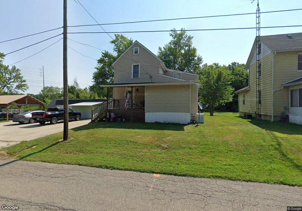
13875 Oyster Rd Alliance, OH 44601
Estimated Value: $90,625 - $208,000
3
Beds
1
Bath
1,456
Sq Ft
$87/Sq Ft
Est. Value
About This Home
This home is located at 13875 Oyster Rd, Alliance, OH 44601 and is currently estimated at $126,156, approximately $86 per square foot. 13875 Oyster Rd is a home located in Mahoning County with nearby schools including Alliance Intermediate School at Northside, Alliance Elementary School at Rockhill, and Alliance Middle School.
Ownership History
Date
Name
Owned For
Owner Type
Purchase Details
Closed on
May 25, 2005
Sold by
Robertson Katie M
Bought by
Robinson Donald J and Robinson Katie M
Current Estimated Value
Home Financials for this Owner
Home Financials are based on the most recent Mortgage that was taken out on this home.
Original Mortgage
$51,520
Outstanding Balance
$27,259
Interest Rate
6.07%
Mortgage Type
New Conventional
Estimated Equity
$98,897
Purchase Details
Closed on
Aug 3, 2004
Sold by
Kosa Gary W and Kosa Deborah S
Bought by
Robertson Katie M
Home Financials for this Owner
Home Financials are based on the most recent Mortgage that was taken out on this home.
Original Mortgage
$46,949
Interest Rate
6.34%
Mortgage Type
Purchase Money Mortgage
Purchase Details
Closed on
Apr 21, 2003
Sold by
Sky Bank
Bought by
Kosa Gary W and Kosa Deborah S
Purchase Details
Closed on
Sep 5, 2002
Sold by
Brooks Robert
Bought by
Sky Bank
Purchase Details
Closed on
May 17, 2002
Sold by
Brooks Robert
Bought by
Sky Bank
Purchase Details
Closed on
Mar 19, 1987
Bought by
Brooks Robert and Brooks Karen
Create a Home Valuation Report for This Property
The Home Valuation Report is an in-depth analysis detailing your home's value as well as a comparison with similar homes in the area
Home Values in the Area
Average Home Value in this Area
Purchase History
| Date | Buyer | Sale Price | Title Company |
|---|---|---|---|
| Robinson Donald J | -- | Cresent Title Agency Llc | |
| Robertson Katie M | $47,000 | Heritage Title Agency | |
| Kosa Gary W | $25,000 | -- | |
| Sky Bank | $25,800 | -- | |
| Sky Bank | $25,800 | -- | |
| Brooks Robert | $35,000 | -- |
Source: Public Records
Mortgage History
| Date | Status | Borrower | Loan Amount |
|---|---|---|---|
| Open | Robinson Donald J | $51,520 | |
| Closed | Robertson Katie M | $46,949 |
Source: Public Records
Tax History Compared to Growth
Tax History
| Year | Tax Paid | Tax Assessment Tax Assessment Total Assessment is a certain percentage of the fair market value that is determined by local assessors to be the total taxable value of land and additions on the property. | Land | Improvement |
|---|---|---|---|---|
| 2024 | $855 | $20,600 | $7,850 | $12,750 |
| 2023 | $890 | $20,600 | $7,850 | $12,750 |
| 2022 | $584 | $13,000 | $5,330 | $7,670 |
| 2021 | $585 | $13,000 | $5,330 | $7,670 |
| 2020 | $608 | $13,000 | $5,330 | $7,670 |
| 2019 | $569 | $11,780 | $5,330 | $6,450 |
| 2018 | $622 | $11,780 | $5,330 | $6,450 |
| 2017 | $689 | $11,780 | $5,330 | $6,450 |
| 2016 | $759 | $14,390 | $6,910 | $7,480 |
| 2015 | $746 | $14,390 | $6,910 | $7,480 |
| 2014 | $775 | $14,390 | $6,910 | $7,480 |
| 2013 | $767 | $14,390 | $6,910 | $7,480 |
Source: Public Records
Map
Nearby Homes
- 22841 Lake Park Blvd
- 831 Wade Ave
- 263 Franklin Ave
- 442 S Liberty Ave
- 1233 Woodland Ave
- 814 Milner St
- 328 N Webb Ave
- 548 E High St
- 1044 S Liberty Ave
- V/L S Fredeom Ave
- 452 E Summit St
- 432 S Linden Ave
- 404 S Linden Ave
- 652 N Webb Ave
- 729 Waugh St
- 834 Devine St
- 815 Grace St
- 1005 S Freedom Ave
- 361 E Main St
- 1437 S Linden Ave
- 13907 Oyster Rd
- 22412 Shady St
- 13824 Oyster Rd
- 22425 Shady St
- 22437 Shady St
- 22451 Shady St
- 22469 Shady St
- 13996 Oyster Rd
- 22505 Railroad St
- 13728 Oyster Rd
- 22519 Railroad St
- 22394 Lake Park Blvd
- 13970 Helen St
- 0 Lake Park Blvd Unit 3250712
- 22385 Lake Park Blvd
- 13984 Helen St
- 13666 Oyster Rd
- 14103 Oyster Rd
- 22489 Lake Park Blvd
- 22657 Railroad St