A
Seller's Agent in 2025
Alyson Roslonek
Milestone Realty, Inc.

Estimated Value: $315,000 - $325,628
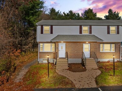
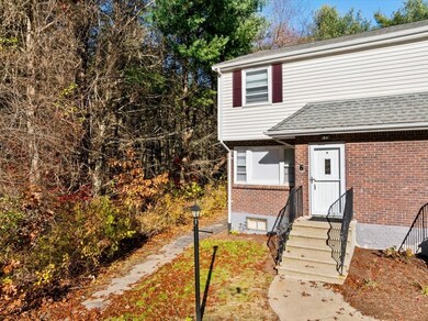
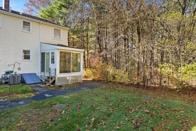
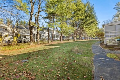
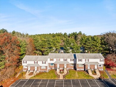
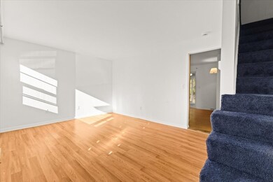
Why rent when you can own? This end-unit condo delivers great value in a peaceful, well-maintained neighborhood with two dedicated parking spaces. Inside, the inviting floor plan features 2 bedrooms, 1.5 baths, and an impressive updated kitchen, renovated in 2014, with stainless appliances, abundant countertop space, and plenty of cabinetry for storage and meal prep. A bright 3-season room just off the kitchen expands your living space, while the finished lower level offers the perfect bonus room, office, or playroom. Additional highlights include a fully renovated full bathroom (2022), a newer furnace (2021), natural gas heat, and in-unit laundry. This condo blends comfort, convenience, and affordability in a desirable location.
Last Agent to Sell the Property
Alyson Roslonek
Milestone Realty, Inc. Listed on: 11/19/2025
We collect this data history from publicly available records. To have your information removed, we recommend requesting removal directly through your county’s website.
| Date | Buyer | Sale Price | Title Company |
|---|---|---|---|
| Malik Sanjay | $310,000 | -- | |
| Goodwan Richard | -- | -- | |
| Goodwan Richard W | -- | -- | |
| Goodwin Richard W | $87,700 | -- |
We collect this data history from publicly available records. To have your information removed, we recommend requesting removal directly through your county’s website.
| Date | Status | Borrower | Loan Amount |
|---|---|---|---|
| Previous Owner | Goodwin Richard W | $68,500 |
| Date | Event | Price | List to Sale | Price per Sq Ft |
|---|---|---|---|---|
| 12/23/2025 12/23/25 | Sold | $310,000 | -1.6% | $233 / Sq Ft |
| 12/08/2025 12/08/25 | Pending | -- | -- | -- |
| 12/04/2025 12/04/25 | For Sale | $315,000 | 0.0% | $236 / Sq Ft |
| 11/23/2025 11/23/25 | Pending | -- | -- | -- |
| 11/19/2025 11/19/25 | For Sale | $315,000 | -- | $236 / Sq Ft |
| Year | Tax Paid | Tax Assessment Tax Assessment Total Assessment is a certain percentage of the fair market value that is determined by local assessors to be the total taxable value of land and additions on the property. | Land | Improvement |
|---|---|---|---|---|
| 2025 | $36 | $279,200 | $0 | $279,200 |
| 2024 | $3,471 | $268,000 | $0 | $268,000 |
| 2023 | $3,112 | $239,600 | $0 | $239,600 |
| 2022 | $2,833 | $198,700 | $0 | $198,700 |
| 2021 | $2,671 | $178,900 | $0 | $178,900 |
| 2020 | $2,466 | $166,600 | $0 | $166,600 |
| 2019 | $5,560 | $162,800 | $0 | $162,800 |
| 2018 | $2,383 | $157,200 | $0 | $157,200 |
| 2017 | $2,281 | $148,400 | $0 | $148,400 |
| 2016 | $2,423 | $155,200 | $0 | $155,200 |
| 2015 | $2,342 | $152,200 | $0 | $152,200 |
| 2014 | $2,041 | $132,800 | $0 | $132,800 |
A
Seller's Agent in 2025
Alyson Roslonek
Milestone Realty, Inc.
D
Buyer's Agent in 2025
David Boni
RISE REC
(401) 228-4626
1 in this area
52 Total Sales
Source: MLS Property Information Network (MLS PIN)
MLS Number: 73456364
APN: NORT-000012-000000-000080F-000006
Disclaimer: Certain information contained herein is derived from information provided by parties other than Homes.com. All information provided is deemed reliable, but is not guaranteed to be accurate and should be independently verified.
![]() The property listing data and information, or the Images, set forth herein were provided to MLS Property Information Network, Inc. from third party sources, including sellers, lessors and public records, and were compiled by MLS Property Information Network, Inc. The property listing data and information, and the Images, are for the personal, non-commercial use of consumers having a good faith interest in purchasing or leasing listed properties of the type displayed to them and may not be used for any purpose other than to identify prospective properties which such consumers may have a good faith interest in purchasing or leasing. MLS Property Information Network, Inc. and its subscribers disclaim any and all representations and warranties as to the accuracy of the property listing data and information, or as to the accuracy of any of the Images, set forth herein.
The property listing data and information, or the Images, set forth herein were provided to MLS Property Information Network, Inc. from third party sources, including sellers, lessors and public records, and were compiled by MLS Property Information Network, Inc. The property listing data and information, and the Images, are for the personal, non-commercial use of consumers having a good faith interest in purchasing or leasing listed properties of the type displayed to them and may not be used for any purpose other than to identify prospective properties which such consumers may have a good faith interest in purchasing or leasing. MLS Property Information Network, Inc. and its subscribers disclaim any and all representations and warranties as to the accuracy of the property listing data and information, or as to the accuracy of any of the Images, set forth herein.
Ask me questions while you tour the home.
