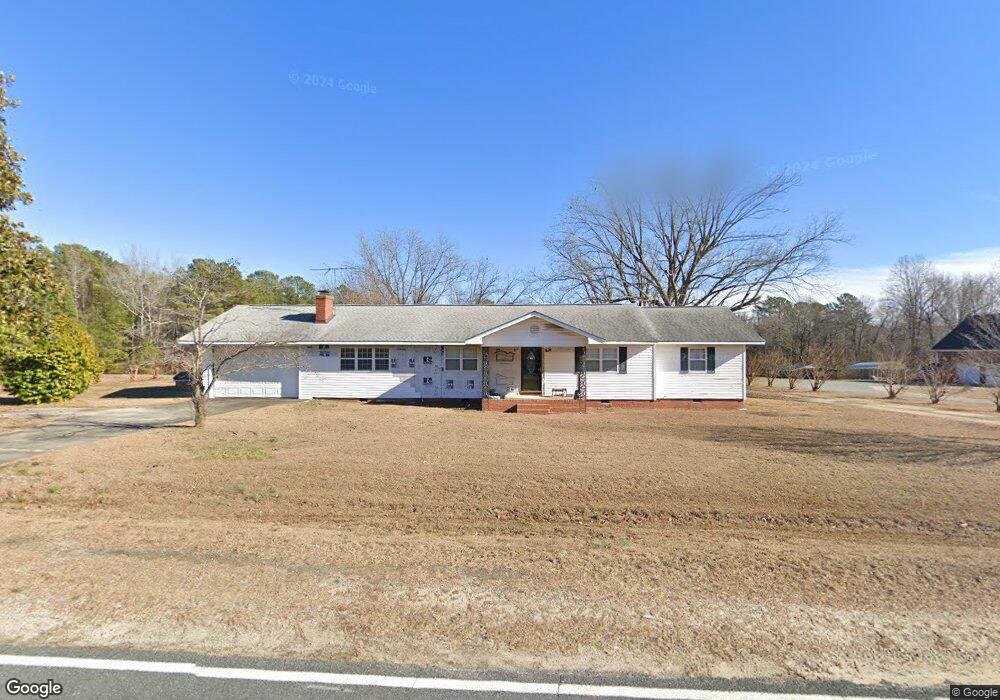
139 C P Stewart Rd Lillington, NC 27546
Estimated Value: $231,000 - $296,000
3
Beds
2
Baths
1,964
Sq Ft
$137/Sq Ft
Est. Value
About This Home
This home is located at 139 C P Stewart Rd, Lillington, NC 27546 and is currently estimated at $268,425, approximately $136 per square foot. 139 C P Stewart Rd is a home located in Harnett County with nearby schools including Boone Trail Elementary School, Western Harnett Middle School, and Western Harnett High School.
Ownership History
Date
Name
Owned For
Owner Type
Purchase Details
Closed on
Oct 7, 2010
Sold by
Mcneill Randall L and Mcneill Jane
Bought by
Bouchard Jason Clive and Bouchard Judy L
Current Estimated Value
Purchase Details
Closed on
May 7, 2010
Sold by
Mcneill Randall L and Mcneill Jane J
Bought by
Bouchard Jason Clive and Bouchard Judy L
Home Financials for this Owner
Home Financials are based on the most recent Mortgage that was taken out on this home.
Original Mortgage
$70,000
Interest Rate
4.79%
Mortgage Type
New Conventional
Create a Home Valuation Report for This Property
The Home Valuation Report is an in-depth analysis detailing your home's value as well as a comparison with similar homes in the area
Home Values in the Area
Average Home Value in this Area
Purchase History
| Date | Buyer | Sale Price | Title Company |
|---|---|---|---|
| Bouchard Jason Clive | -- | -- | |
| Bouchard Jason Clive | $120,000 | -- | |
| Bouchard Jason Clive | -- | -- |
Source: Public Records
Mortgage History
| Date | Status | Borrower | Loan Amount |
|---|---|---|---|
| Previous Owner | Bouchard Jason Clive | $70,000 |
Source: Public Records
Tax History Compared to Growth
Tax History
| Year | Tax Paid | Tax Assessment Tax Assessment Total Assessment is a certain percentage of the fair market value that is determined by local assessors to be the total taxable value of land and additions on the property. | Land | Improvement |
|---|---|---|---|---|
| 2025 | $1,137 | $152,219 | $0 | $0 |
| 2024 | $1,137 | $152,219 | $0 | $0 |
| 2023 | $1,137 | $152,219 | $0 | $0 |
| 2022 | $1,067 | $152,219 | $0 | $0 |
| 2021 | $1,067 | $119,750 | $0 | $0 |
| 2020 | $1,067 | $119,750 | $0 | $0 |
| 2019 | $1,052 | $119,750 | $0 | $0 |
| 2018 | $1,052 | $119,750 | $0 | $0 |
| 2017 | $1,052 | $119,750 | $0 | $0 |
| 2016 | $1,101 | $125,770 | $0 | $0 |
| 2015 | $1,101 | $125,770 | $0 | $0 |
| 2014 | $1,101 | $125,770 | $0 | $0 |
Source: Public Records
Map
Nearby Homes
- 61 Greenhouse Ct
- 226 Community Rd
- 6080 Us 421 N
- 339 Hookbill (Lot 24) Ln
- 369 Hookbill (Lot 26) Ln
- 69 Hookbill Ln
- 69 Hookbill Ln Unit Lot 9
- 145 Hookbill Ln
- 145 Hookbill Ln Unit Lot 13
- 355 Hookbill (Lot 25) Ln
- 372 Hookbill (Lot 106) Ln
- 26 Charred Oak Ct
- 25 Charred Oak Ct
- 63 Charred Oak Ct
- 67 Single Barrel Ct
- 61 Single Barrel Ct
- 57 Blanton Ct
- 4198 Spring Hill Church Rd
- 2651 Tim Currin Rd
- 173 Old Fashioned Way
- 00 C P Stewart
- 75 C P Stewart Rd
- 86 C P Stewart Rd
- 55 C P Stewart Rd
- 248 C P Stewart Rd
- 32 C P Stewart Rd
- 21 C P Stewart Rd
- 5845 Old Us 421
- 263 C P Stewart Rd
- 1 C P Stewart Rd
- 5965 Old Us Highway 421
- 5965 Old Us 421
- 5965 Old Us 421
- 5801 Old Us 421
- 283 C P Stewart Rd
- 5838 Old Us 421 Unit 1
- 5838 Old Us 421 Unit 3
- 5898 Old Us 421
- 5832 Old Us 421
- 5830 Old Us 421