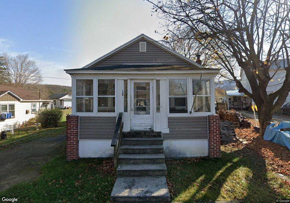
139 Cinder Ln Paw Paw, WV 25434
Estimated Value: $90,000 - $167,000
3
Beds
1
Bath
1,415
Sq Ft
$93/Sq Ft
Est. Value
About This Home
This home is located at 139 Cinder Ln, Paw Paw, WV 25434 and is currently estimated at $131,667, approximately $93 per square foot. 139 Cinder Ln is a home with nearby schools including Paw Paw Elementary School and Paw Paw High School.
Ownership History
Date
Name
Owned For
Owner Type
Purchase Details
Closed on
Apr 6, 2025
Sold by
Braithwaite Gary Chad and Davis Melissa D
Bought by
Abe Devin Ty
Current Estimated Value
Purchase Details
Closed on
Oct 24, 2005
Sold by
Davis James E and Davis Melissa D
Bought by
Davis Melissa D and Braithwaite Gary Chad
Home Financials for this Owner
Home Financials are based on the most recent Mortgage that was taken out on this home.
Original Mortgage
$6,025
Interest Rate
6.07%
Mortgage Type
New Conventional
Create a Home Valuation Report for This Property
The Home Valuation Report is an in-depth analysis detailing your home's value as well as a comparison with similar homes in the area
Home Values in the Area
Average Home Value in this Area
Purchase History
| Date | Buyer | Sale Price | Title Company |
|---|---|---|---|
| Abe Devin Ty | $500 | None Listed On Document | |
| Davis Melissa D | -- | -- |
Source: Public Records
Mortgage History
| Date | Status | Borrower | Loan Amount |
|---|---|---|---|
| Previous Owner | Davis Melissa D | $6,025 |
Source: Public Records
Tax History Compared to Growth
Tax History
| Year | Tax Paid | Tax Assessment Tax Assessment Total Assessment is a certain percentage of the fair market value that is determined by local assessors to be the total taxable value of land and additions on the property. | Land | Improvement |
|---|---|---|---|---|
| 2025 | $623 | $50,220 | $2,700 | $47,520 |
| 2024 | $576 | $46,020 | $2,460 | $43,560 |
| 2023 | $576 | $45,060 | $2,460 | $42,600 |
| 2022 | $558 | $44,580 | $2,460 | $42,120 |
| 2021 | $257 | $20,580 | $2,460 | $18,120 |
| 2020 | $509 | $40,680 | $2,460 | $38,220 |
| 2019 | $488 | $39,000 | $2,460 | $36,540 |
| 2018 | $473 | $37,860 | $2,460 | $35,400 |
| 2017 | $473 | $37,860 | $2,460 | $35,400 |
| 2016 | $483 | $38,640 | $2,460 | $36,180 |
| 2015 | $466 | $40,020 | $2,160 | $37,860 |
| 2014 | $466 | $37,320 | $2,340 | $34,980 |
Source: Public Records
Map
Nearby Homes
- 86 McCoole Ave
- 525 Winchester St
- 32 Bullett Alley
- 310 Bethel Rd
- 273 Potomac St
- 40 Winchester St
- 914 Plains Rd
- 94 Moreland Ct
- 59 Back Country Rd
- 0 Bethel Rd Unit WVMO2006714
- 427 Avalanche Trail
- 3225 Magnolia Rd
- 22322 Cacapon Rd
- Lot 17 Gaither Rd
- 1580 Gaither Rd
- 812 Lonesome Pine Ln
- SEC 17 LOT 27 Bottom Rd
- 3 Blumb Ln
- 4 Blumb Ln
- 1327 Golliday Ln
- 131 Cinder Ln
- 143 Cinder Ln
- 44 McCoole Ave
- 16 McCoole Ave
- 365 Winchester St
- 70 McCoole Ave
- 33 McCoole Ave
- 362 Winchester St
- 70 McCoole Ave
- 15 McCoole Ave
- 381 Winchester St
- 5 McCoole Ave
- 61 McCoole Ave
- 86 McCoole Ave
- 76 McCoole Ave
- 356 Mc Coole Ave
- 28 Dr Randolph Spencer Ln
- 360 McCoole Ave
- 7 Dr Randolph Spencer Ln St
- 268 Winchester St