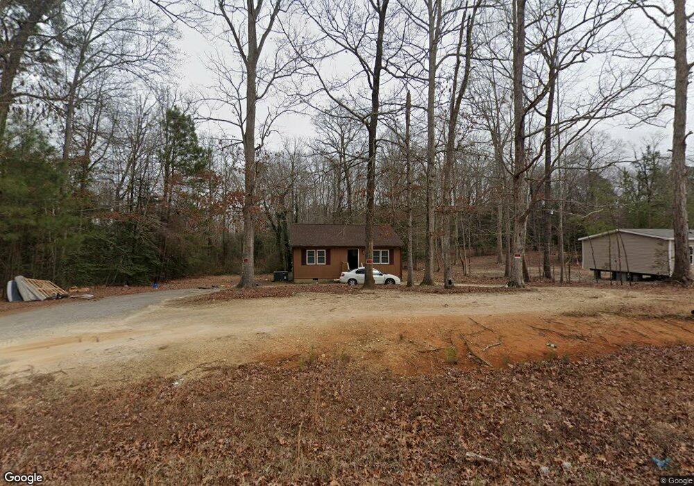
139 Farley Cir Roanoke Rapids, NC 27870
Estimated Value: $13,000 - $139,000
--
Bed
--
Bath
--
Sq Ft
0.46
Acres
About This Home
This home is located at 139 Farley Cir, Roanoke Rapids, NC 27870 and is currently estimated at $77,333. 139 Farley Cir is a home located in Halifax County with nearby schools including Aurelian Springs Elementary School, William R. Davie Middle School, and Northwest Halifax High School.
Ownership History
Date
Name
Owned For
Owner Type
Purchase Details
Closed on
Jan 14, 2025
Sold by
Cmh Homes Inc
Bought by
Tilmon Quiana
Current Estimated Value
Home Financials for this Owner
Home Financials are based on the most recent Mortgage that was taken out on this home.
Original Mortgage
$15,000
Outstanding Balance
$14,926
Interest Rate
7.04%
Estimated Equity
$62,407
Purchase Details
Closed on
May 20, 2024
Sold by
Austin Roy E
Bought by
Cmh Homes Inc
Purchase Details
Closed on
Jan 1, 1982
Bought by
Austin Roy
Create a Home Valuation Report for This Property
The Home Valuation Report is an in-depth analysis detailing your home's value as well as a comparison with similar homes in the area
Home Values in the Area
Average Home Value in this Area
Purchase History
| Date | Buyer | Sale Price | Title Company |
|---|---|---|---|
| Tilmon Quiana | $140,000 | None Listed On Document | |
| Tilmon Quiana | $140,000 | None Listed On Document | |
| Cmh Homes Inc | $15,000 | None Listed On Document | |
| Cmh Homes Inc | $15,000 | None Listed On Document | |
| Austin Roy | -- | -- |
Source: Public Records
Mortgage History
| Date | Status | Borrower | Loan Amount |
|---|---|---|---|
| Open | Tilmon Quiana | $15,000 | |
| Closed | Tilmon Quiana | $15,000 | |
| Open | Tilmon Quiana | $92,451 | |
| Closed | Tilmon Quiana | $92,451 |
Source: Public Records
Tax History Compared to Growth
Tax History
| Year | Tax Paid | Tax Assessment Tax Assessment Total Assessment is a certain percentage of the fair market value that is determined by local assessors to be the total taxable value of land and additions on the property. | Land | Improvement |
|---|---|---|---|---|
| 2025 | $0 | $4,800 | $4,800 | $0 |
| 2024 | $0 | $4,800 | $4,800 | $0 |
| 2023 | $46 | $4,800 | $4,800 | $0 |
| 2022 | $44 | $4,800 | $4,800 | $0 |
| 2021 | $44 | $4,800 | $4,800 | $0 |
| 2020 | $44 | $4,800 | $4,800 | $0 |
| 2019 | $45 | $4,800 | $4,800 | $0 |
| 2018 | $45 | $4,800 | $4,800 | $0 |
| 2017 | $45 | $4,800 | $4,800 | $0 |
| 2016 | $41 | $4,800 | $4,800 | $0 |
| 2015 | $38 | $4,800 | $4,800 | $0 |
| 2014 | -- | $5,170 | $5,170 | $0 |
Source: Public Records
Map
Nearby Homes
- 217 Easton St
- 0 Stonegate Dr Unit 140195
- 0 Stonegate Dr Unit 136251
- 0 Highway 125 Unit 122510
- 0 Jennifers Ln Unit 140138
- 38 Buttercup Ln
- 62 Hickory Cir
- 63 Hickory Cir
- 40 Green Ash Ct
- 38 Green Ash Ct
- 39 Green Ash Ct
- 37 Bald Eagle Dr
- 21 Bald Eagle Dr
- 25 Bald Eagle Dr
- 29 Bald Eagle Dr
- 31 Bald Eagle Dr
- 33 Bald Eagle Dr
- 35 Bald Eagle Dr
- 24 Bald Eagle Dr
- 26 Bald Eagle Dr
- 175 Farley Cir
- 55 Cosmos Ln
- 195 Farley Cir
- 196 Farley Cir
- 2080 Sam Powell Dairy Rd
- 248 Farley Cir
- 52 Farley Cir
- 266 Farley Cir
- 266 Farley Cir
- 231 Farley Cir
- 2147 Sam Powell Dairy Rd
- 2087 Sam Powell Dairy Rd
- 2195 Sam Powell Dairy Rd
- 311 Farley Cir
- 138 Cosmos Ln
- 2277 Sam Powell Dairy Rd
- 331 Farley Cir
- 2048 Sam Powell Dairy Rd
- 2202 Sam Powell Dairy Rd
- 56 Star Dr