
Landlord's Agent in 2025
Preston Hall
Keller Williams Realty
(617) 620-5493
8 in this area
32 Total Sales


Estimated Value: $1,120,270 - $1,221,000
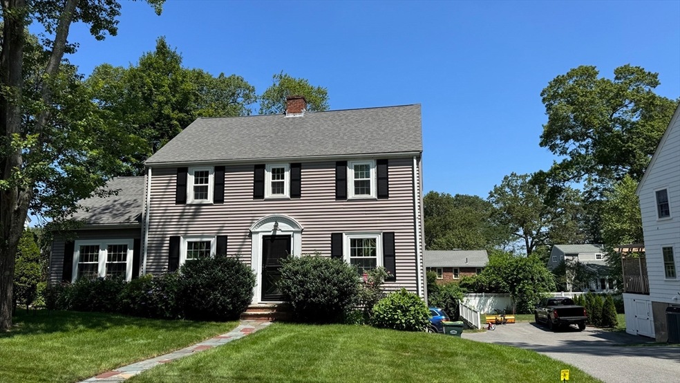
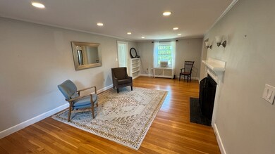
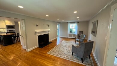
Still time to move in before the school year starts! This charming home is nestled in a sought-after enclave neighborhood in the Newman Elementary School district, just minutes from downtown Needham and the Needham Junction commuter rail. Offering 1,846 sq ft, 3 spacious bedrooms, and 1.5 baths, this home blends classic comfort with modern updates. The remodeled kitchen features granite countertops and stainless steel appliances, perfect for home cooking and entertaining. Enjoy the generous, newer family room—ideal for movie nights and watching the big game. Numerous upgrades include newer windows, siding, roof, insulation, and a high-efficiency boiler, providing comfort and energy savings year-round. A fantastic opportunity to enjoy a great home in an unbeatable location! Text agent for video.
| Date | Buyer | Sale Price | Title Company |
|---|---|---|---|
| Levy Aaron S | $519,900 | -- |
| Date | Status | Borrower | Loan Amount |
|---|---|---|---|
| Open | Levy Aaron S | $389,925 |
| Date | Event | Price | List to Sale | Price per Sq Ft |
|---|---|---|---|---|
| 08/13/2025 08/13/25 | Rented | $4,600 | 0.0% | -- |
| 08/08/2025 08/08/25 | Under Contract | -- | -- | -- |
| 07/29/2025 07/29/25 | For Rent | $4,600 | -- | -- |
| Year | Tax Paid | Tax Assessment Tax Assessment Total Assessment is a certain percentage of the fair market value that is determined by local assessors to be the total taxable value of land and additions on the property. | Land | Improvement |
|---|---|---|---|---|
| 2025 | $10,019 | $945,200 | $748,200 | $197,000 |
| 2024 | $9,960 | $795,500 | $497,800 | $297,700 |
| 2023 | $10,063 | $771,700 | $497,800 | $273,900 |
| 2022 | $9,743 | $728,700 | $461,000 | $267,700 |
| 2021 | $9,495 | $728,700 | $461,000 | $267,700 |
| 2020 | $8,984 | $719,300 | $461,200 | $258,100 |
| 2019 | $8,367 | $675,300 | $419,300 | $256,000 |
| 2018 | $8,023 | $675,300 | $419,300 | $256,000 |
| 2017 | $7,667 | $644,800 | $419,300 | $225,500 |
| 2016 | $7,229 | $626,400 | $419,300 | $207,100 |
| 2015 | $7,072 | $626,400 | $419,300 | $207,100 |
| 2014 | $6,764 | $581,100 | $381,200 | $199,900 |
Landlord's Agent in 2025
Preston Hall
Keller Williams Realty
(617) 620-5493
8 in this area
32 Total Sales
Tenant's Agent in 2025
The Samantha Eisenberg Group
Compass
43 in this area
94 Total Sales
Source: MLS Property Information Network (MLS PIN)
MLS Number: 73410771
APN: NEED-000037-000009
Disclaimer: Certain information contained herein is derived from information provided by parties other than Homes.com. All information provided is deemed reliable, but is not guaranteed to be accurate and should be independently verified.
![]() The property listing data and information, or the Images, set forth herein were provided to MLS Property Information Network, Inc. from third party sources, including sellers, lessors and public records, and were compiled by MLS Property Information Network, Inc. The property listing data and information, and the Images, are for the personal, non-commercial use of consumers having a good faith interest in purchasing or leasing listed properties of the type displayed to them and may not be used for any purpose other than to identify prospective properties which such consumers may have a good faith interest in purchasing or leasing. MLS Property Information Network, Inc. and its subscribers disclaim any and all representations and warranties as to the accuracy of the property listing data and information, or as to the accuracy of any of the Images, set forth herein.
The property listing data and information, or the Images, set forth herein were provided to MLS Property Information Network, Inc. from third party sources, including sellers, lessors and public records, and were compiled by MLS Property Information Network, Inc. The property listing data and information, and the Images, are for the personal, non-commercial use of consumers having a good faith interest in purchasing or leasing listed properties of the type displayed to them and may not be used for any purpose other than to identify prospective properties which such consumers may have a good faith interest in purchasing or leasing. MLS Property Information Network, Inc. and its subscribers disclaim any and all representations and warranties as to the accuracy of the property listing data and information, or as to the accuracy of any of the Images, set forth herein.
Ask me questions while you tour the home.