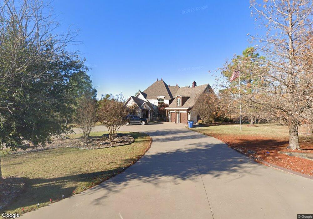
139 Liberty Cir McAlester, OK 74501
Estimated Value: $456,000 - $556,799
3
Beds
3
Baths
3,584
Sq Ft
$145/Sq Ft
Est. Value
About This Home
This home is located at 139 Liberty Cir, McAlester, OK 74501 and is currently estimated at $518,700, approximately $144 per square foot. 139 Liberty Cir is a home located in Pittsburg County with nearby schools including Krebs Public School.
Ownership History
Date
Name
Owned For
Owner Type
Purchase Details
Closed on
May 13, 2025
Sold by
Hilton Angie Marie
Bought by
Amg Trust
Current Estimated Value
Purchase Details
Closed on
May 13, 2005
Sold by
Wilson Lindell W and Wilson Donna J
Bought by
Hilton Angie
Purchase Details
Closed on
Aug 15, 2002
Sold by
Peaceable Village Inc
Bought by
Wilson Lindell
Create a Home Valuation Report for This Property
The Home Valuation Report is an in-depth analysis detailing your home's value as well as a comparison with similar homes in the area
Home Values in the Area
Average Home Value in this Area
Purchase History
| Date | Buyer | Sale Price | Title Company |
|---|---|---|---|
| Amg Trust | -- | None Listed On Document | |
| Hilton Angie | $30,000 | None Available | |
| Wilson Lindell | $22,000 | -- |
Source: Public Records
Tax History Compared to Growth
Tax History
| Year | Tax Paid | Tax Assessment Tax Assessment Total Assessment is a certain percentage of the fair market value that is determined by local assessors to be the total taxable value of land and additions on the property. | Land | Improvement |
|---|---|---|---|---|
| 2024 | $4,151 | $48,921 | $3,740 | $45,181 |
| 2023 | $4,151 | $46,592 | $3,740 | $42,852 |
| 2022 | $4,029 | $46,592 | $3,740 | $42,852 |
| 2021 | $4,035 | $46,592 | $3,740 | $42,852 |
| 2020 | $4,006 | $46,592 | $3,740 | $42,852 |
| 2019 | $3,912 | $46,300 | $3,740 | $42,560 |
| 2018 | $3,719 | $43,182 | $3,740 | $39,442 |
| 2017 | $3,601 | $41,126 | $3,740 | $37,386 |
| 2016 | $3,455 | $39,168 | $3,740 | $35,428 |
| 2015 | $2,559 | $34,320 | $3,410 | $30,910 |
| 2014 | $2,559 | $34,320 | $3,410 | $30,910 |
Source: Public Records
Map
Nearby Homes
- 30 Georgetown Cir
- 902 Village Blvd
- 108 Stubbs Ln
- 713 Kinkead Rd
- 525 SW 3rd St
- 16 Kinkead Rd
- 345 SW 4th St
- 813 Kinkead Rd
- 0 N Highway 69 Unit 2522963
- 260 W Buttermilk Rd
- 00 N Highway 69
- 910 Summit Ridge
- 510 W Jackson Ave
- 1406 Country Club Rd
- 5 Karen Ct
- 1014 Newton Dr
- 0 Silva Unit 2439216
- 1411 Timber Ln
- 1507 E Seminole Ave
- 1508 E Comanche Ave
- 137 Liberty Cir
- 141 Liberty Cir
- 143 Liberty Cir
- 125 Liberty Cir
- 135 Liberty Cir
- 134 Liberty Cir
- 123 Liberty Cir
- 132 Liberty Cir
- 26 Georgetown Cir
- 32 Georgetown Cir
- 147 Liberty Cir
- 121 Liberty Cir
- 0 Liberty Cir Unit 1550439
- 0 Liberty Cir Unit 1609662
- 0 Liberty Cir Unit 1632717
- 0 Liberty Cir Unit 1710787
- 0 Liberty Cir Unit 1711055
- 0 Liberty Cir Unit 1732590
- 0 Liberty Cir Unit 1832291
- 0 Liberty Cir Unit 1832518