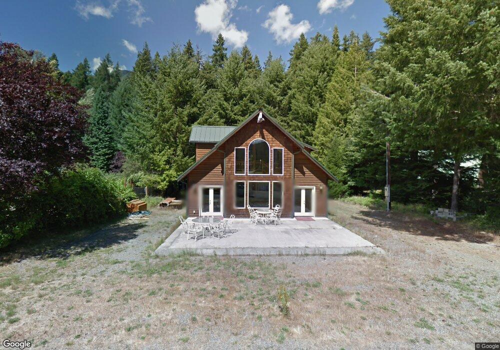
139 Maple Place Packwood, WA 98361
Estimated Value: $583,700 - $847,000
3
Beds
2
Baths
1,600
Sq Ft
$428/Sq Ft
Est. Value
About This Home
This home is located at 139 Maple Place, Packwood, WA 98361 and is currently estimated at $684,175, approximately $427 per square foot. 139 Maple Place is a home located in Lewis County with nearby schools including White Pass Elementary School and White Pass Junior/Senior High School.
Ownership History
Date
Name
Owned For
Owner Type
Purchase Details
Closed on
Oct 13, 2003
Sold by
Riewer Steven G and Riewer Rita M
Bought by
Joplin Ralph and Joplin Kathleen
Current Estimated Value
Home Financials for this Owner
Home Financials are based on the most recent Mortgage that was taken out on this home.
Original Mortgage
$128,000
Interest Rate
5.37%
Mortgage Type
New Conventional
Create a Home Valuation Report for This Property
The Home Valuation Report is an in-depth analysis detailing your home's value as well as a comparison with similar homes in the area
Home Values in the Area
Average Home Value in this Area
Purchase History
| Date | Buyer | Sale Price | Title Company |
|---|---|---|---|
| Joplin Ralph | -- | Lewis County Title |
Source: Public Records
Mortgage History
| Date | Status | Borrower | Loan Amount |
|---|---|---|---|
| Previous Owner | Joplin Ralph | $128,000 |
Source: Public Records
Tax History Compared to Growth
Tax History
| Year | Tax Paid | Tax Assessment Tax Assessment Total Assessment is a certain percentage of the fair market value that is determined by local assessors to be the total taxable value of land and additions on the property. | Land | Improvement |
|---|---|---|---|---|
| 2024 | $3,899 | $567,200 | $50,700 | $516,500 |
| 2023 | $3,667 | $500,600 | $50,700 | $449,900 |
| 2022 | $3,124 | $340,000 | $39,000 | $301,000 |
| 2021 | $2,595 | $340,000 | $39,000 | $301,000 |
| 2020 | $2,407 | $244,200 | $27,800 | $216,400 |
| 2019 | $2,352 | $211,800 | $23,900 | $187,900 |
| 2018 | $2,164 | $194,500 | $21,500 | $173,000 |
| 2017 | $1,917 | $168,000 | $21,500 | $146,500 |
| 2016 | $1,981 | $163,100 | $20,900 | $142,200 |
| 2015 | $2,496 | $161,400 | $22,000 | $139,400 |
| 2013 | $2,496 | $181,300 | $33,400 | $147,900 |
Source: Public Records
Map
Nearby Homes
- 254 Mountain View Dr
- 171 Timberline Dr
- 119 Timberline Dr W
- 131 Timberline Dr W
- 106 Jack Fir Ct W
- 110 Ridge Ln
- 78 Fir Park Ln
- 191 Forest Ridge Dr
- 118 Silver Tip Ln
- 123 Campfire Ln
- 111 Campfire Ln
- 127 Campfire Ln
- 125 Campfire Ln
- 131 Campfire Ln
- 103 Buttercreek Ln
- 0 Cannon Rd Unit NWM2416527
- 0 Lot 12 Slalom Way
- 178 Mount Rainier Dr
- 120 Rainbow Ln
- 156 Lot 2 Sasquatch Ln
- 143 Maple Place
- 131 Maple Place
- 145 Maple Place
- 132 Maple Place
- 132 Maple Place
- 134 Maple Place
- 140 Maple Place
- 0 Maple Ct
- 130 Maple Place
- 0 Maple Ct Unit 1382603
- 105 Maple Ct
- 107 Maple Ct
- 123 Maple Place
- 118 Maple Place
- 114 Maple Place
- 119 Maple Place
- 104 Good Times Ln
- 106 Good Times Ln
- 112 Maple Place