Estimated Value: $149,000 - $265,000
3
Beds
2
Baths
1,800
Sq Ft
$123/Sq Ft
Est. Value
About This Home
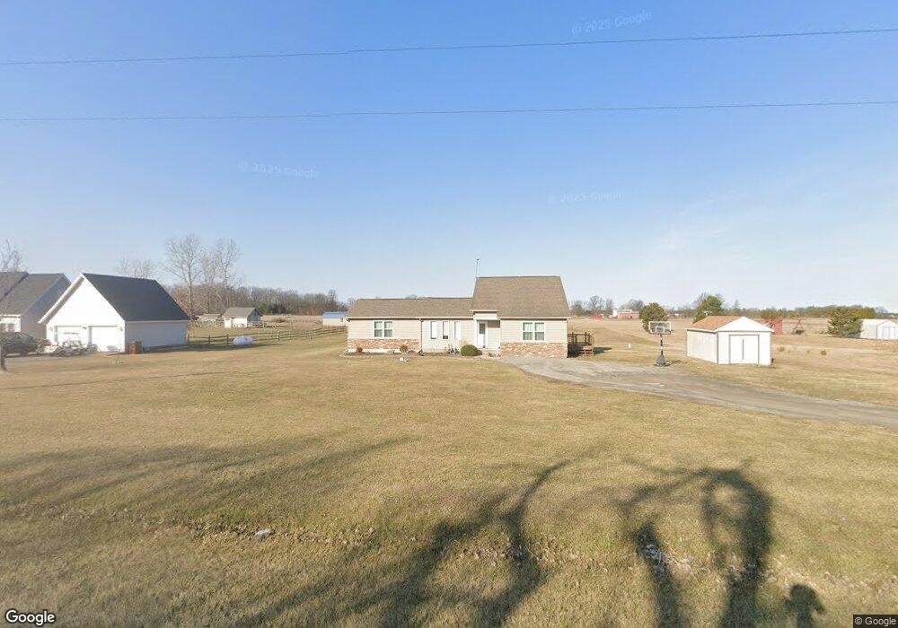
This home is located at 139 State Route 235, Ada, OH 45810 and is currently estimated at $222,193, approximately $123 per square foot. 139 State Route 235 is a home located in Hardin County with nearby schools including Ada Elementary School and Ada High School.
Ownership History
Date
Name
Owned For
Owner Type
Purchase Details
Closed on
Sep 28, 2011
Sold by
Pinks David L
Bought by
Craig Tyler and Craig Brittany
Current Estimated Value
Home Financials for this Owner
Home Financials are based on the most recent Mortgage that was taken out on this home.
Original Mortgage
$24,000
Outstanding Balance
$16,400
Interest Rate
4.14%
Mortgage Type
Purchase Money Mortgage
Estimated Equity
$205,793
Purchase Details
Closed on
Sep 6, 1996
Bought by
Pinks David L and Pinks Linda S
Purchase Details
Closed on
Jul 31, 1996
Bought by
Roby Leroy
Create a Home Valuation Report for This Property
The Home Valuation Report is an in-depth analysis detailing your home's value as well as a comparison with similar homes in the area
Home Values in the Area
Average Home Value in this Area
Purchase History
| Date | Buyer | Sale Price | Title Company |
|---|---|---|---|
| Craig Tyler | $30,000 | None Available | |
| Pinks David L | $72,500 | -- | |
| Roby Leroy | $7,000 | -- |
Source: Public Records
Mortgage History
| Date | Status | Borrower | Loan Amount |
|---|---|---|---|
| Open | Craig Tyler | $24,000 |
Source: Public Records
Tax History Compared to Growth
Tax History
| Year | Tax Paid | Tax Assessment Tax Assessment Total Assessment is a certain percentage of the fair market value that is determined by local assessors to be the total taxable value of land and additions on the property. | Land | Improvement |
|---|---|---|---|---|
| 2024 | $2,183 | $57,720 | $8,750 | $48,970 |
| 2023 | $2,183 | $57,720 | $8,750 | $48,970 |
| 2022 | $1,765 | $40,590 | $4,410 | $36,180 |
| 2021 | $1,955 | $40,590 | $4,410 | $36,180 |
| 2020 | $1,974 | $40,590 | $4,410 | $36,180 |
| 2019 | $1,720 | $35,790 | $4,200 | $31,590 |
| 2018 | $1,683 | $35,790 | $4,200 | $31,590 |
| 2017 | $1,641 | $35,790 | $4,200 | $31,590 |
| 2016 | $1,710 | $39,400 | $3,680 | $35,720 |
| 2015 | $1,686 | $39,400 | $3,680 | $35,720 |
| 2014 | $1,669 | $39,400 | $3,680 | $35,720 |
| 2013 | $1,780 | $39,680 | $3,680 | $36,000 |
Source: Public Records
Map
Nearby Homes
- 3769 County Road 304
- 3600 Township Road 27
- 22694 County Road 12
- 629 N Main St
- 128 W North Ave
- 444 Edwards St Unit A, B
- 444 Edwards St Unit 2
- 442 Edwards St
- 210 N Gilbert St
- 211 S Main St
- 212 N Simon St
- 211 W Buckeye Ave Unit 211 1/2
- 301 S Main St
- 308-310 S Simon St
- 00 Lincoln Hwy
- 314 E University Ave
- 710 S Main St
- 4071 Township Road 35
- 20515 County Road 15
- 000 Lincoln Hwy