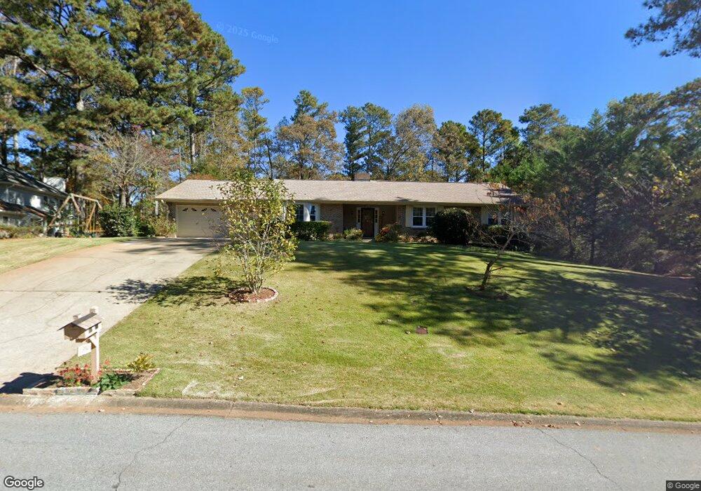
1390 Doe Hollow Trace SW Unit 1 Lilburn, GA 30047
Estimated Value: $379,905 - $413,000
3
Beds
2
Baths
1,933
Sq Ft
$203/Sq Ft
Est. Value
About This Home
This home is located at 1390 Doe Hollow Trace SW Unit 1, Lilburn, GA 30047 and is currently estimated at $392,976, approximately $203 per square foot. 1390 Doe Hollow Trace SW Unit 1 is a home located in Gwinnett County with nearby schools including Head Elementary School, Five Forks Middle School, and Brookwood High School.
Ownership History
Date
Name
Owned For
Owner Type
Purchase Details
Closed on
Aug 18, 2015
Sold by
Brignoni Patria
Bought by
Brignoni Samuel and Birgnoni Patria
Current Estimated Value
Purchase Details
Closed on
Jul 27, 2005
Sold by
Brignoni Zaida E
Bought by
Brignoni Patria
Purchase Details
Closed on
Oct 31, 2003
Sold by
Burt Lynn P
Bought by
Brignoni Zaida E
Home Financials for this Owner
Home Financials are based on the most recent Mortgage that was taken out on this home.
Original Mortgage
$160,481
Interest Rate
5.93%
Mortgage Type
VA
Create a Home Valuation Report for This Property
The Home Valuation Report is an in-depth analysis detailing your home's value as well as a comparison with similar homes in the area
Home Values in the Area
Average Home Value in this Area
Purchase History
| Date | Buyer | Sale Price | Title Company |
|---|---|---|---|
| Brignoni Samuel | -- | -- | |
| Brignoni Patria | $165,000 | -- | |
| Brignoni Zaida E | $163,000 | -- |
Source: Public Records
Mortgage History
| Date | Status | Borrower | Loan Amount |
|---|---|---|---|
| Previous Owner | Brignoni Zaida E | $160,481 |
Source: Public Records
Tax History Compared to Growth
Tax History
| Year | Tax Paid | Tax Assessment Tax Assessment Total Assessment is a certain percentage of the fair market value that is determined by local assessors to be the total taxable value of land and additions on the property. | Land | Improvement |
|---|---|---|---|---|
| 2025 | -- | $145,160 | $30,000 | $115,160 |
| 2024 | $1,024 | $141,120 | $30,000 | $111,120 |
| 2023 | $1,024 | $134,000 | $31,200 | $102,800 |
| 2022 | $983 | $125,240 | $27,600 | $97,640 |
| 2021 | $970 | $83,520 | $19,600 | $63,920 |
| 2020 | $968 | $83,520 | $19,600 | $63,920 |
| 2019 | $901 | $83,520 | $19,600 | $63,920 |
| 2018 | $882 | $76,800 | $19,600 | $57,200 |
| 2016 | $913 | $63,520 | $16,000 | $47,520 |
| 2015 | $930 | $61,600 | $14,000 | $47,600 |
| 2014 | $940 | $61,600 | $14,000 | $47,600 |
Source: Public Records
Map
Nearby Homes
- 1394 Rustlewood Ct SW
- 1102 Timber Glen Ct SW
- 1315 Killian Shoals Way SW
- 4070 Runnymede Dr SW
- 1535 Pathfinder Way SW Unit 1
- 4327 Saint Michaels Dr SW
- 1640 Killian Hill Rd SW
- 0 River Club Dr Unit 7650571
- 1043 Wash Lee Dr SW
- 3868 Buckland Dr SW
- 1725 Spindle Top Ct SW
- 1530 Oleander Ln SW
- 1732 Beauregard Dr SW
- 1093 Hasty Ct SW
- 3846 Teresa Terrace SW
- 4107 Signal Ridge SW
- 1400 Doe Hollow Trace SW
- 0 Doe Hollow Trace SW
- 1391 Doe Hollow Trace SW
- 1380 Doe Hollow Trace SW
- 1380 Doe Hollow Trace SW Unit 1
- 1410 Doe Hollow Trace SW Unit 4
- 1401 Doe Hollow Trace SW
- 4052 Deerbrook Way SW Unit 3
- 4052 Deerbrook Way SW
- 1411 Doe Hollow Trace SW Unit 4
- 1421 Doe Hollow Trace SW Unit 4
- 4072 Deerbrook Way SW
- 0 Deerbrook Way SW Unit 3174395
- 0 Deerbrook Way SW Unit 8687384
- 0 Deerbrook Way SW Unit 3131000
- 0 Deerbrook Way SW Unit 3075997
- 1420 Doe Hollow Trace SW
- 4033 Deerbrook Way SW
- 4082 Deerbrook Way SW
- 4012 Deerbrook Way SW