Estimated Value: $104,595 - $244,000
3
Beds
1
Bath
1,724
Sq Ft
$113/Sq Ft
Est. Value
About This Home
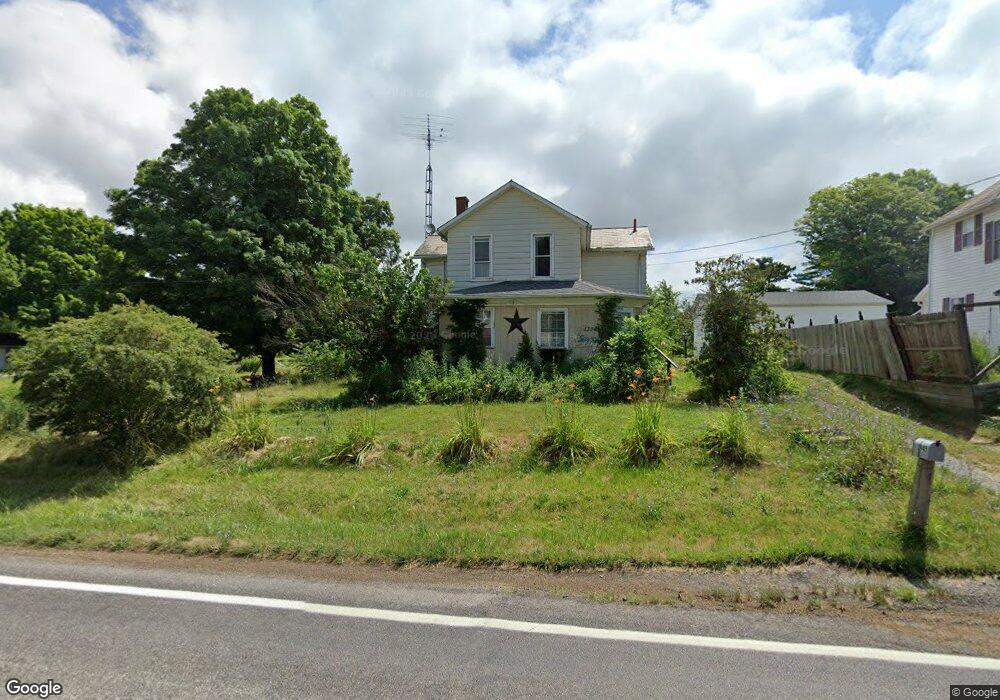
This home is located at 13945 S Pricetown Rd, Salem, OH 44460 and is currently estimated at $194,149, approximately $112 per square foot. 13945 S Pricetown Rd is a home with nearby schools including West Branch Middle School and West Branch High School.
Ownership History
Date
Name
Owned For
Owner Type
Purchase Details
Closed on
Oct 13, 2025
Sold by
Smith Roger Dale and Smith Ruth M
Bought by
Huntington Lisa A
Current Estimated Value
Purchase Details
Closed on
May 10, 2005
Sold by
Smith Nancy J
Bought by
Smith Roger Dale
Home Financials for this Owner
Home Financials are based on the most recent Mortgage that was taken out on this home.
Original Mortgage
$37,775
Interest Rate
5.71%
Mortgage Type
Credit Line Revolving
Purchase Details
Closed on
Jun 5, 1969
Bought by
Smith Roger D and Smith Nancy J
Create a Home Valuation Report for This Property
The Home Valuation Report is an in-depth analysis detailing your home's value as well as a comparison with similar homes in the area
Home Values in the Area
Average Home Value in this Area
Purchase History
| Date | Buyer | Sale Price | Title Company |
|---|---|---|---|
| Huntington Lisa A | $30,000 | None Listed On Document | |
| Smith Roger Dale | $23,500 | Heritage Title Agency | |
| Smith Roger D | -- | -- |
Source: Public Records
Mortgage History
| Date | Status | Borrower | Loan Amount |
|---|---|---|---|
| Previous Owner | Smith Roger Dale | $37,775 |
Source: Public Records
Tax History Compared to Growth
Tax History
| Year | Tax Paid | Tax Assessment Tax Assessment Total Assessment is a certain percentage of the fair market value that is determined by local assessors to be the total taxable value of land and additions on the property. | Land | Improvement |
|---|---|---|---|---|
| 2024 | $1,114 | $27,600 | $1,800 | $25,800 |
| 2023 | $1,169 | $27,600 | $1,800 | $25,800 |
| 2022 | $1,246 | $27,750 | $1,800 | $25,950 |
| 2021 | $1,211 | $27,750 | $1,800 | $25,950 |
| 2020 | $1,216 | $27,750 | $1,800 | $25,950 |
| 2019 | $629 | $21,910 | $1,800 | $20,110 |
| 2018 | $658 | $21,910 | $1,800 | $20,110 |
| 2017 | $603 | $21,910 | $1,800 | $20,110 |
| 2016 | $500 | $19,570 | $1,800 | $17,770 |
| 2015 | $487 | $19,570 | $1,800 | $17,770 |
| 2014 | $469 | $19,570 | $1,800 | $17,770 |
| 2013 | $487 | $19,570 | $1,800 | $17,770 |
Source: Public Records
Map
Nearby Homes
- 14930 S Pricetown Rd
- 14831 Smith Goshen Rd
- 14965 Seacrist Rd
- 14980 Salem Alliance Rd
- 29979 Salem-Alliance Rd
- 30051 Sr 62
- 17394 State Route 62
- 28339 Misty Morning Ln
- 27443 State Route 62
- 18061 Derr Ave
- 17880 State Route 62
- 15772 Cleveland - East Liverpool Rd
- 35 Bayview Dr
- 14609 S Duck Creek Rd
- 18 Boxwood Dr
- 11 Redwood St
- 57 Redwood St
- 73 Redwood St
- 26223 Wildwood Dr
- 1445 Georgetown Damascus Rd
- 13985 S Pricetown Rd
- 418-420 Third St
- 16024 Garfield Rd
- 13948 S Pricetown Rd
- 16024 W Garfield Rd
- 0 W Garfield Rd Unit 1215000
- 0 W Garfield Rd Unit 4501617
- 15970 Garfield Rd
- 13925 State Route 534
- 15995 Garfield Rd
- 13926 State Route 534
- 16062 Garfield Rd
- 14036 S Pricetown Rd
- 14063 State Route 534
- 13853 S Pricetown Rd
- 13853 State Route 534
- 13839 State Route 534
- 14084 State Route 534
- 15891 Garfield Rd
- 14134 S Pricetown Rd