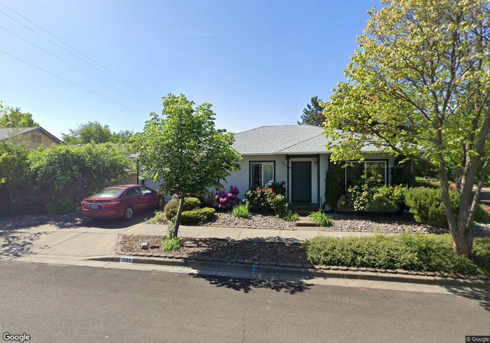
1396 Mill Pond Rd Ashland, OR 97520
Millpond NeighborhoodEstimated Value: $403,850 - $531,000
3
Beds
2
Baths
1,092
Sq Ft
$436/Sq Ft
Est. Value
About This Home
This home is located at 1396 Mill Pond Rd, Ashland, OR 97520 and is currently estimated at $475,713, approximately $435 per square foot. 1396 Mill Pond Rd is a home located in Jackson County with nearby schools including Walker Elementary School, Ashland Middle School, and Ashland High School.
Ownership History
Date
Name
Owned For
Owner Type
Purchase Details
Closed on
Sep 25, 2015
Sold by
Vidmar Dale J
Bought by
Liv Gabrielle Karine and Karine Gabrielle Revocable Living Trust
Current Estimated Value
Purchase Details
Closed on
May 11, 2011
Sold by
Gabrielle Karine and Vidmar Dale James
Bought by
Liv Gabrille Karine and Karine Gabrielle Revocable Living Trust
Create a Home Valuation Report for This Property
The Home Valuation Report is an in-depth analysis detailing your home's value as well as a comparison with similar homes in the area
Home Values in the Area
Average Home Value in this Area
Purchase History
| Date | Buyer | Sale Price | Title Company |
|---|---|---|---|
| Liv Gabrielle Karine | -- | None Available | |
| Liv Gabrille Karine | -- | None Available |
Source: Public Records
Tax History Compared to Growth
Tax History
| Year | Tax Paid | Tax Assessment Tax Assessment Total Assessment is a certain percentage of the fair market value that is determined by local assessors to be the total taxable value of land and additions on the property. | Land | Improvement |
|---|---|---|---|---|
| 2025 | $3,456 | $222,880 | $69,040 | $153,840 |
| 2024 | $3,456 | $216,390 | $67,030 | $149,360 |
| 2023 | $3,343 | $210,090 | $65,080 | $145,010 |
| 2022 | $3,236 | $210,090 | $65,080 | $145,010 |
| 2021 | $3,126 | $203,980 | $63,190 | $140,790 |
| 2020 | $3,038 | $198,040 | $61,350 | $136,690 |
| 2019 | $2,990 | $186,680 | $57,840 | $128,840 |
| 2018 | $2,825 | $181,250 | $56,160 | $125,090 |
| 2017 | $2,804 | $181,250 | $56,160 | $125,090 |
| 2016 | $2,731 | $170,860 | $52,940 | $117,920 |
| 2015 | $2,626 | $170,860 | $52,940 | $117,920 |
| 2014 | $2,540 | $161,060 | $49,900 | $111,160 |
Source: Public Records
Map
Nearby Homes
- 2082 E Main St
- 1259 Hagen Way
- 1123 Village Square Dr
- 380 Hemlock Ln
- 411 N Mountain Ave
- 65 S Mountain Ave
- 1040 E Main St
- 1245 Iowa St Unit 7
- 496 Starflower Ln
- 533 N Mountain Ave
- 557 N Mountain Ave
- 453 Williamson Way
- 753 Siskiyou Blvd
- 124 Morton St
- 401 Clinton St
- 545 A St
- 391 Clinton St Unit 5200
- 586 B St
- 381 Clinton St Unit 5200
- 403 Briscoe Place
- 1388 Mill Pond Rd
- 123 N Wightman St
- 115 N Wightman St
- 1389 Mill Pond Rd
- 1399 Mill Pond Rd
- 1380 Mill Pond Rd
- 107 N Wightman St
- 139 Wightman St
- 139 N Wightman St
- 0 Mill Pond Rd
- 99 N Wightman St
- 1390 Romeo Dr
- 1372 Mill Pond Rd
- 149 Wightman St
- 1381 Romeo Dr
- 1341 Evan Ln
- 1351 Evan Ln
- 1361 Evan Ln
- 91 N Wightman St
- 122 N Wightman St