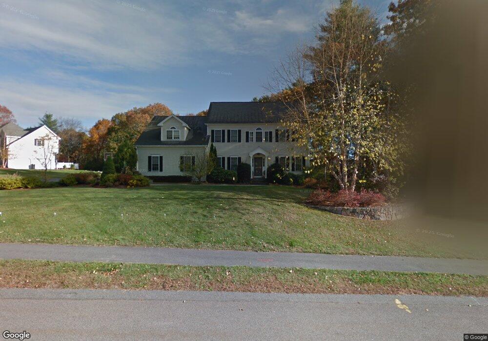
14 Broken Tree Rd Medway, MA 02053
Estimated Value: $1,039,743 - $1,239,000
4
Beds
3
Baths
2,995
Sq Ft
$383/Sq Ft
Est. Value
About This Home
This home is located at 14 Broken Tree Rd, Medway, MA 02053 and is currently estimated at $1,146,686, approximately $382 per square foot. 14 Broken Tree Rd is a home located in Norfolk County with nearby schools including John D. McGovern Elementary School, Burke-Memorial Elementary, and Medway Middle School.
Ownership History
Date
Name
Owned For
Owner Type
Purchase Details
Closed on
May 20, 2021
Sold by
Donovan Beth D and Donovan John W
Bought by
Beth D Donovan Ret
Current Estimated Value
Purchase Details
Closed on
Mar 12, 1999
Sold by
Alexander Capital Dev
Bought by
Donovan John W and Donovan Beth D
Create a Home Valuation Report for This Property
The Home Valuation Report is an in-depth analysis detailing your home's value as well as a comparison with similar homes in the area
Home Values in the Area
Average Home Value in this Area
Purchase History
| Date | Buyer | Sale Price | Title Company |
|---|---|---|---|
| Beth D Donovan Ret | -- | None Available | |
| Donovan John W | $406,850 | -- |
Source: Public Records
Mortgage History
| Date | Status | Borrower | Loan Amount |
|---|---|---|---|
| Previous Owner | Donovan John W | $396,000 | |
| Previous Owner | Donovan John W | $413,000 | |
| Previous Owner | Donovan John W | $150,000 | |
| Previous Owner | Donovan John W | $300,000 |
Source: Public Records
Tax History Compared to Growth
Tax History
| Year | Tax Paid | Tax Assessment Tax Assessment Total Assessment is a certain percentage of the fair market value that is determined by local assessors to be the total taxable value of land and additions on the property. | Land | Improvement |
|---|---|---|---|---|
| 2025 | $12,419 | $871,500 | $339,900 | $531,600 |
| 2024 | $12,550 | $871,500 | $339,900 | $531,600 |
| 2023 | $11,992 | $752,300 | $309,400 | $442,900 |
| 2022 | $11,181 | $660,400 | $228,800 | $431,600 |
| 2021 | $11,314 | $648,000 | $213,500 | $434,500 |
| 2020 | $11,190 | $639,400 | $213,500 | $425,900 |
| 2019 | $10,669 | $628,700 | $204,800 | $423,900 |
| 2018 | $10,992 | $622,400 | $204,800 | $417,600 |
| 2017 | $10,639 | $593,700 | $196,100 | $397,600 |
| 2016 | $10,127 | $559,200 | $185,200 | $374,000 |
| 2015 | $10,085 | $552,900 | $185,200 | $367,700 |
| 2014 | $10,646 | $565,100 | $215,700 | $349,400 |
Source: Public Records
Map
Nearby Homes
- 1 Walnut Ln
- 30 Broken Tree Rd
- 106 Holliston St
- 12 Lovering St
- 73 Orchard St
- 140 Goulding St
- 19 Sycamore Way Unit L40
- 3 Meryl St
- 1 Jameson Dr Unit 1
- 3 Jameson Dr Unit 3
- 36 Lovering St
- 50 Main St
- 0 Hill St
- 625 Norfolk St
- 6 Glen Ellen Blvd Unit 6
- 18 Lansing Way Unit 18
- 20 Lansing Way Unit 20
- 9 Bogastow Cir
- 14 Heritage Dr
- 22 Sunset Dr
- 16 Broken Tree Rd
- 13 Broken Tree Rd
- 11 Broken Tree Rd
- 5 Hickory Dr
- 15 Broken Tree Rd
- 9 Hickory Dr
- 18 Broken Tree Rd
- 11 Hickory Dr
- 9 Broken Tree Rd
- 17 Broken Tree Rd
- 2 Hickory Dr
- 4 Hickory Dr
- 6 Hickory Dr
- 13 Hickory Dr
- 38 Broken Tree Rd
- 8 Walnut Ln
- 5 Walnut Ln
- 20 Broken Tree Rd
- 0 Lot 49 Walnut Ln Unit 50368955
- 17 Hickory Dr