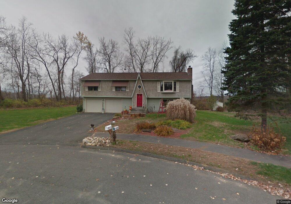
14 Bunker Hill Rd Feeding Hills, MA 01030
Estimated Value: $356,000 - $510,000
3
Beds
3
Baths
1,456
Sq Ft
$286/Sq Ft
Est. Value
About This Home
This home is located at 14 Bunker Hill Rd, Feeding Hills, MA 01030 and is currently estimated at $416,082, approximately $285 per square foot. 14 Bunker Hill Rd is a home located in Hampden County with nearby schools including Agawam Junior High School and Agawam High School.
Ownership History
Date
Name
Owned For
Owner Type
Purchase Details
Closed on
Feb 24, 2011
Sold by
Roulier Stephen A
Bought by
Roulier Sharon A
Current Estimated Value
Home Financials for this Owner
Home Financials are based on the most recent Mortgage that was taken out on this home.
Original Mortgage
$95,000
Outstanding Balance
$65,151
Interest Rate
4.75%
Estimated Equity
$350,931
Purchase Details
Closed on
Sep 17, 1992
Sold by
Park West B and Park T
Bought by
Roulier Stephen A and Roulier Sharon A
Home Financials for this Owner
Home Financials are based on the most recent Mortgage that was taken out on this home.
Original Mortgage
$101,600
Interest Rate
8.04%
Mortgage Type
Purchase Money Mortgage
Purchase Details
Closed on
Jun 15, 1992
Sold by
Crooker Peter C
Bought by
Park West B and Park T
Create a Home Valuation Report for This Property
The Home Valuation Report is an in-depth analysis detailing your home's value as well as a comparison with similar homes in the area
Home Values in the Area
Average Home Value in this Area
Purchase History
| Date | Buyer | Sale Price | Title Company |
|---|---|---|---|
| Roulier Sharon A | -- | -- | |
| Roulier Stephen A | $127,000 | -- | |
| Park West B | $105,000 | -- |
Source: Public Records
Mortgage History
| Date | Status | Borrower | Loan Amount |
|---|---|---|---|
| Open | Roulier Sharon A | $95,000 | |
| Previous Owner | Park West B | $94,000 | |
| Previous Owner | Park West B | $101,600 | |
| Previous Owner | Park West B | $140,000 |
Source: Public Records
Tax History Compared to Growth
Tax History
| Year | Tax Paid | Tax Assessment Tax Assessment Total Assessment is a certain percentage of the fair market value that is determined by local assessors to be the total taxable value of land and additions on the property. | Land | Improvement |
|---|---|---|---|---|
| 2025 | $4,928 | $336,600 | $130,400 | $206,200 |
| 2024 | $4,785 | $329,100 | $130,400 | $198,700 |
| 2023 | $4,706 | $298,200 | $117,600 | $180,600 |
| 2022 | $4,609 | $286,100 | $117,600 | $168,500 |
| 2021 | $4,477 | $266,500 | $100,200 | $166,300 |
| 2020 | $4,426 | $263,000 | $98,200 | $164,800 |
| 2019 | $4,154 | $249,500 | $95,300 | $154,200 |
| 2018 | $3,963 | $238,600 | $95,300 | $143,300 |
| 2017 | $3,784 | $232,000 | $95,300 | $136,700 |
| 2016 | $3,660 | $226,200 | $95,300 | $130,900 |
| 2015 | $3,609 | $229,300 | $95,300 | $134,000 |
Source: Public Records
Map
Nearby Homes
- 122 Southwick St
- 387 Southwick St
- 550 Southwick St
- 200 Anvil St
- 306 Feeding Hills Rd
- 50 Muriel Ln
- 92 Juniper Ridge Dr
- 36-38 Orlando St
- 60 Elizabeth St
- 157 Cambridge St
- 1085 N Street Extension
- 999 N Street Extension
- 4 Liquori Dr
- 215 Barry St
- 141 Barry St
- 691 Mill St
- 7 Agnoli Place
- 511 Shoemaker Ln
- 67 Colemore St
- 8 N Longyard Rd
- 10 Bunker Hill Rd
- 4 Independence Rd
- 6 Bunker Hill Rd
- 3 Independence Rd
- 94 Paul Revere Dr
- 92 1/2 Paul Revere Dr
- 96 Paul Revere Dr
- 92 Paul Revere Dr
- 100 Paul Revere Dr
- 99 Paul Revere Dr
- 103 Paul Revere Dr
- 11 Independence Rd
- 104 Paul Revere Dr
- 18 Independence Rd
- 109 Paul Revere Dr
- 17 Independence Rd
- 158 Elmar Dr
- 108 Paul Revere Dr
- 113 Paul Revere Dr
- 22 Independence Rd