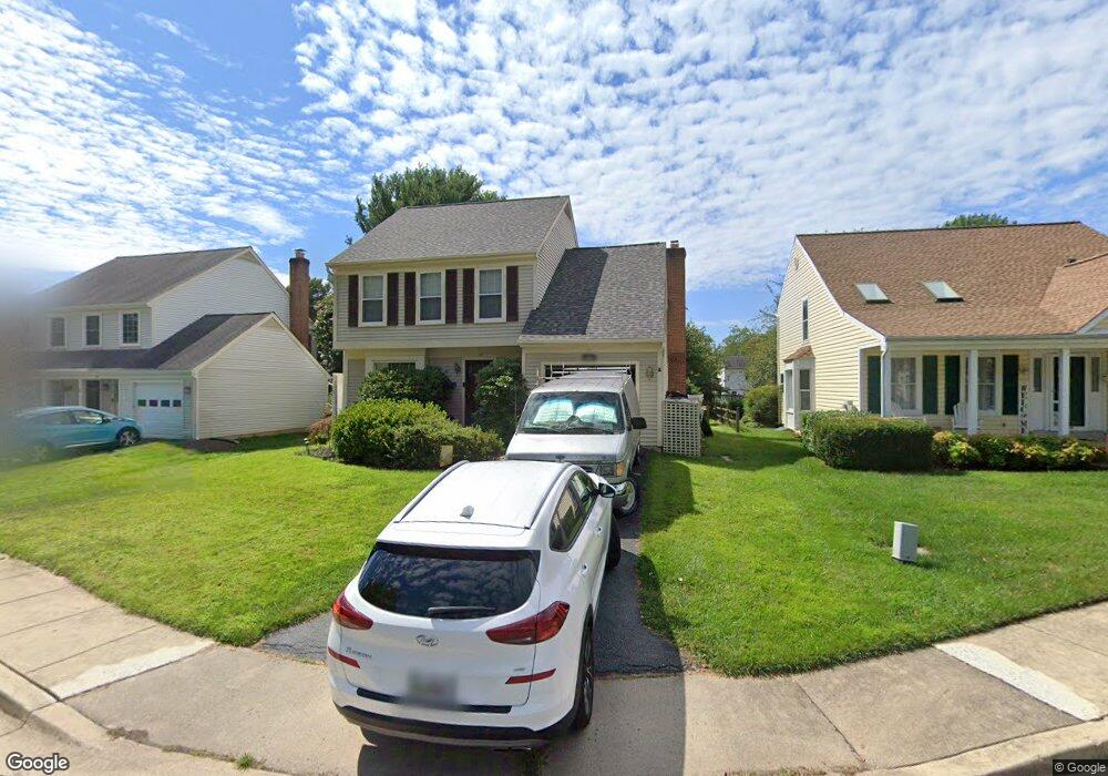
14 Burnt Woods Ct Germantown, MD 20874
Estimated Value: $516,586 - $574,000
--
Bed
3
Baths
1,660
Sq Ft
$333/Sq Ft
Est. Value
About This Home
This home is located at 14 Burnt Woods Ct, Germantown, MD 20874 and is currently estimated at $552,897, approximately $333 per square foot. 14 Burnt Woods Ct is a home located in Montgomery County with nearby schools including Waters Landing Elementary School, Dr. Martin Luther King, Jr. Middle School, and Seneca Valley High School.
Ownership History
Date
Name
Owned For
Owner Type
Purchase Details
Closed on
Oct 2, 1998
Sold by
J Patrick D and J Millspaw C
Bought by
Lefebvre Mark and Lefebvre P
Current Estimated Value
Purchase Details
Closed on
Apr 11, 1994
Sold by
Wessel M E
Bought by
Millspaw Patrick D
Home Financials for this Owner
Home Financials are based on the most recent Mortgage that was taken out on this home.
Original Mortgage
$135,600
Interest Rate
7.27%
Create a Home Valuation Report for This Property
The Home Valuation Report is an in-depth analysis detailing your home's value as well as a comparison with similar homes in the area
Home Values in the Area
Average Home Value in this Area
Purchase History
| Date | Buyer | Sale Price | Title Company |
|---|---|---|---|
| Lefebvre Mark | $169,500 | -- | |
| Millspaw Patrick D | $169,500 | -- |
Source: Public Records
Mortgage History
| Date | Status | Borrower | Loan Amount |
|---|---|---|---|
| Previous Owner | Millspaw Patrick D | $135,600 |
Source: Public Records
Tax History Compared to Growth
Tax History
| Year | Tax Paid | Tax Assessment Tax Assessment Total Assessment is a certain percentage of the fair market value that is determined by local assessors to be the total taxable value of land and additions on the property. | Land | Improvement |
|---|---|---|---|---|
| 2025 | $5,067 | $417,567 | -- | -- |
| 2024 | $5,067 | $401,300 | $149,400 | $251,900 |
| 2023 | $5,513 | $382,067 | $0 | $0 |
| 2022 | $3,720 | $362,833 | $0 | $0 |
| 2021 | $3,343 | $343,600 | $149,400 | $194,200 |
| 2020 | $3,343 | $335,833 | $0 | $0 |
| 2019 | $3,243 | $328,067 | $0 | $0 |
| 2018 | $3,156 | $320,300 | $149,400 | $170,900 |
| 2017 | $3,108 | $310,300 | $0 | $0 |
| 2016 | -- | $300,300 | $0 | $0 |
| 2015 | $2,993 | $290,300 | $0 | $0 |
| 2014 | $2,993 | $290,300 | $0 | $0 |
Source: Public Records
Map
Nearby Homes
- 20574 Neerwinder St
- 13643 Spinning Wheel Dr
- 13626 Deerwater Dr
- 20503 Summersong Ln
- 20637 Shadyside Way
- 13003 Shadyside Ln Unit 12211
- 20617 Shadyside Way Unit A
- 20442 Summersong Ln
- 20909 Rosebay Place
- 20408 Shore Harbour Dr
- 20406 Waters Point Ln
- 20406 Shore Harbour Dr Unit 4F
- 20406 Shore Harbour Dr
- 20404 Shore Harbour Dr Unit D
- 20510 Bargene Way
- 20313 Beaconfield Terrace Unit 102
- 20334 Beaconfield Terrace Unit 2
- 20217 Waterside Dr
- 13214 Meander Cove Dr Unit 54
- 13142 Pickering Dr
- 18 Burnt Woods Ct
- 10 Burnt Woods Ct
- 6 Burnt Woods Ct
- 9 Burnt Woods Ct
- 26 Burnt Woods Ct
- 20704 Burnt Woods Dr
- 17 Burnt Woods Ct
- 20700 Burnt Woods Dr
- 5 Burnt Woods Ct
- 13417 Cloverdale Place
- 13413 Cloverdale Place
- 13425 Cloverdale Place
- 21 Burnt Woods Ct
- 13409 Cloverdale Place
- 23 Burnt Woods Ct
- 1 Burnt Woods Ct
- 13405 Cloverdale Place
- 13429 Cloverdale Place
- 13401 Cloverdale Place
- 13433 Cloverdale Place