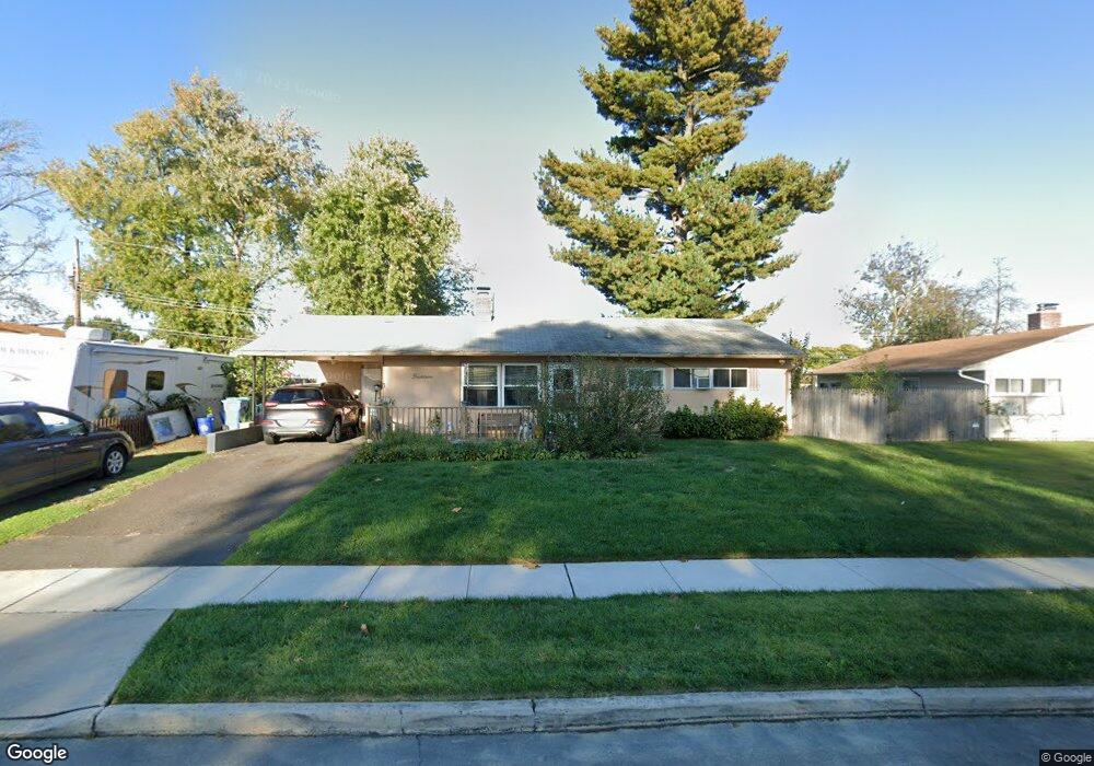
14 Butternut Rd Levittown, PA 19057
Estimated Value: $309,000 - $338,000
3
Beds
1
Bath
1,000
Sq Ft
$321/Sq Ft
Est. Value
About This Home
This home is located at 14 Butternut Rd, Levittown, PA 19057 and is currently estimated at $321,156, approximately $321 per square foot. 14 Butternut Rd is a home located in Bucks County with nearby schools including Truman Senior High School, First Presbyterian Church School, and Hope Lutheran School.
Ownership History
Date
Name
Owned For
Owner Type
Purchase Details
Closed on
Jun 24, 2022
Sold by
Kathleen Rhoades
Bought by
Rhoades Kathleen
Current Estimated Value
Home Financials for this Owner
Home Financials are based on the most recent Mortgage that was taken out on this home.
Original Mortgage
$185,897
Outstanding Balance
$176,618
Interest Rate
5.1%
Mortgage Type
FHA
Estimated Equity
$144,538
Purchase Details
Closed on
Jan 9, 2004
Sold by
Diaz Dina Marie and Diaz Giovanni
Bought by
Wolanski Kathleen
Home Financials for this Owner
Home Financials are based on the most recent Mortgage that was taken out on this home.
Original Mortgage
$112,000
Interest Rate
5.62%
Mortgage Type
Purchase Money Mortgage
Create a Home Valuation Report for This Property
The Home Valuation Report is an in-depth analysis detailing your home's value as well as a comparison with similar homes in the area
Home Values in the Area
Average Home Value in this Area
Purchase History
| Date | Buyer | Sale Price | Title Company |
|---|---|---|---|
| Rhoades Kathleen | -- | First Source Title | |
| Wolanski Kathleen | $140,000 | Madison Title Agency Llc |
Source: Public Records
Mortgage History
| Date | Status | Borrower | Loan Amount |
|---|---|---|---|
| Open | Rhoades Kathleen | $185,897 | |
| Previous Owner | Wolanski Kathleen | $112,000 |
Source: Public Records
Tax History Compared to Growth
Tax History
| Year | Tax Paid | Tax Assessment Tax Assessment Total Assessment is a certain percentage of the fair market value that is determined by local assessors to be the total taxable value of land and additions on the property. | Land | Improvement |
|---|---|---|---|---|
| 2025 | $4,345 | $16,000 | $4,840 | $11,160 |
| 2024 | $4,345 | $16,000 | $4,840 | $11,160 |
| 2023 | $4,313 | $16,000 | $4,840 | $11,160 |
| 2022 | $4,313 | $16,000 | $4,840 | $11,160 |
| 2021 | $4,313 | $16,000 | $4,840 | $11,160 |
| 2020 | $4,313 | $16,000 | $4,840 | $11,160 |
| 2019 | $4,297 | $16,000 | $4,840 | $11,160 |
| 2018 | $4,228 | $16,000 | $4,840 | $11,160 |
| 2017 | $4,164 | $16,000 | $4,840 | $11,160 |
| 2016 | $4,164 | $16,000 | $4,840 | $11,160 |
| 2015 | $2,955 | $16,000 | $4,840 | $11,160 |
| 2014 | $2,955 | $16,000 | $4,840 | $11,160 |
Source: Public Records
Map
Nearby Homes
- 150 Naomi Ct Unit 811
- 1019 Green Ln
- 23 Misty Pine Rd
- 50 Micahill Rd
- 57 Middle Rd
- 2519 Woodlawn Dr
- 145 Mill Dr
- 101 Idlewild Rd
- 3021 Bath Rd
- 2205 Liberator St
- 86 Wildflower Rd
- 5604 Fleetwing Dr
- 47 Plumbridge Dr
- 84 Whitewood Dr
- 212 Plumbridge Dr
- 62 Indian Creek Dr
- 35 Parkside Cir
- 38 Plumtree Rd
- 19 Prunewood Rd
- 5617 Beaver Dam Rd