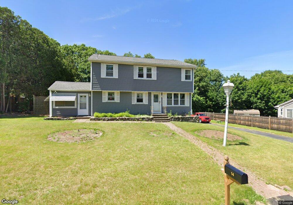
14 Capt Peter Simpson Rd Millbury, MA 01527
Armory Village NeighborhoodEstimated Value: $464,000 - $589,000
5
Beds
2
Baths
1,855
Sq Ft
$293/Sq Ft
Est. Value
About This Home
This home is located at 14 Capt Peter Simpson Rd, Millbury, MA 01527 and is currently estimated at $543,794, approximately $293 per square foot. 14 Capt Peter Simpson Rd is a home located in Worcester County with nearby schools including Elmwood Street Elementary School, Raymond E. Shaw Elementary School, and Millbury Junior/Senior High School.
Ownership History
Date
Name
Owned For
Owner Type
Purchase Details
Closed on
Nov 17, 2020
Sold by
Bouthilette Peter A and Austin Patricia
Bought by
Bouthilette Peter A
Current Estimated Value
Purchase Details
Closed on
Sep 26, 2017
Sold by
Bouthillette Peter A
Bought by
Bouthillette Peter A and Austin Patricia
Purchase Details
Closed on
Sep 5, 2017
Sold by
Bouthillette Peter A
Bought by
Bouthillette Peter A and Austin Patricia
Purchase Details
Closed on
Nov 29, 2016
Sold by
Bouthillette Peter A and Bouthillette Linda A
Bought by
Bouthillette Peter A
Purchase Details
Closed on
Dec 11, 2014
Sold by
Krumsiek Paula A and Austin Patricia M
Bought by
Bouthillette Peter A and Bouthillette Linda A
Purchase Details
Closed on
Feb 6, 2009
Sold by
Bouthillette Arthur
Bought by
Kosiba Pamela and Austin Patricia
Create a Home Valuation Report for This Property
The Home Valuation Report is an in-depth analysis detailing your home's value as well as a comparison with similar homes in the area
Home Values in the Area
Average Home Value in this Area
Purchase History
| Date | Buyer | Sale Price | Title Company |
|---|---|---|---|
| Bouthilette Peter A | -- | None Available | |
| Bouthilette Peter A | -- | None Available | |
| Bouthillette Peter A | -- | -- | |
| Bouthillette Peter A | -- | -- | |
| Bouthillette Peter A | -- | -- | |
| Bouthillette Peter A | -- | -- | |
| Bouthillette Peter A | -- | -- | |
| Bouthillette Peter A | -- | -- | |
| Bouthillette Peter A | -- | -- | |
| Bouthillette Peter A | -- | -- | |
| Kosiba Pamela | -- | -- | |
| Kosiba Pamela | -- | -- |
Source: Public Records
Mortgage History
| Date | Status | Borrower | Loan Amount |
|---|---|---|---|
| Previous Owner | Kosiba Pamela | $57,000 |
Source: Public Records
Tax History Compared to Growth
Tax History
| Year | Tax Paid | Tax Assessment Tax Assessment Total Assessment is a certain percentage of the fair market value that is determined by local assessors to be the total taxable value of land and additions on the property. | Land | Improvement |
|---|---|---|---|---|
| 2025 | $6,550 | $489,200 | $114,400 | $374,800 |
| 2024 | $6,008 | $454,100 | $106,000 | $348,100 |
| 2023 | $5,517 | $381,800 | $74,400 | $307,400 |
| 2022 | $4,977 | $331,800 | $74,400 | $257,400 |
| 2021 | $4,910 | $318,200 | $74,400 | $243,800 |
| 2020 | $4,807 | $313,600 | $74,400 | $239,200 |
| 2019 | $4,673 | $294,800 | $67,500 | $227,300 |
| 2018 | $4,631 | $283,400 | $67,500 | $215,900 |
| 2017 | $4,341 | $264,200 | $67,500 | $196,700 |
| 2016 | $4,057 | $246,500 | $67,500 | $179,000 |
| 2015 | $3,987 | $242,200 | $71,800 | $170,400 |
| 2014 | $3,699 | $216,300 | $71,800 | $144,500 |
Source: Public Records
Map
Nearby Homes
- 4 Thomas Hill Rd
- 19 Rice Rd
- 16 Jackie Dr
- 2 Jessica j Dr
- 39 S Main St
- 4 Jessica j Dr
- 5 Mogren Dr
- 128 Worcester Providence Turnpike
- 124 Worcester Providence Turnpike
- 7 Canal St
- 37-39 Main St
- Lot 1 Cooper Rd
- 8 Autumn Gate Cir
- 38 W Main St
- 18 Lincoln Ave
- 168 Burbank Rd
- 123 Riverlin St
- 150 Ariel Cir
- 115 Ariel Cir
- 20 Woodridge Rd
- 16 Capt Peter Simpson Rd
- 12 Capt Peter Simpson Rd
- 18 Capt Peter Simpson Rd
- 14 Thomas Hill Rd
- 12 Thomas Hill Rd
- 15 Capt Peter Simpson Rd
- 17 Capt Peter Simpson Rd
- 19 Capt Peter Simpson Rd
- 13 Capt Peter Simpson Rd
- 11 Capt Peter Simpson Rd
- 8 Thomas Hill Rd
- 13 Thomas Hill Rd
- 11 Thomas Hill Rd
- 1 Ilyas Ln Unit 1A
- 1 Ilyas Ln Unit 2
- 7 Capt Peter Simpson Rd
- 7 Captain Peter Simpson Rd
- 91 S Main St
- 4 Capt Peter Simpson Rd
- 5 Thomas Hill Rd