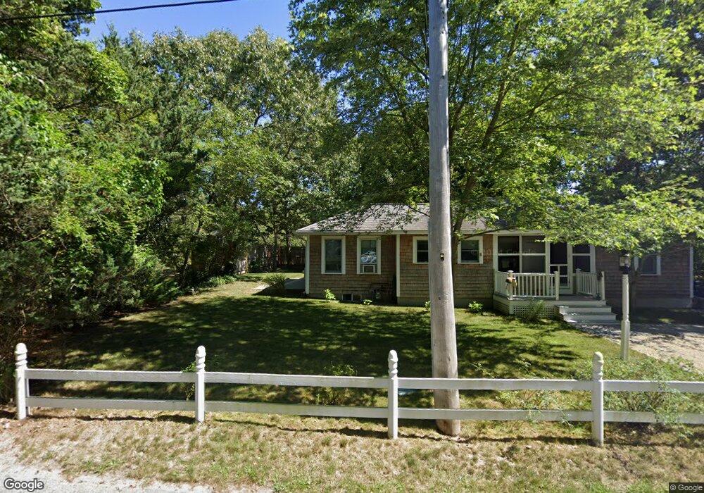
14 Chase St Dennis Port, MA 02639
Dennis Port NeighborhoodEstimated Value: $629,000 - $803,000
3
Beds
2
Baths
1,201
Sq Ft
$601/Sq Ft
Est. Value
About This Home
This home is located at 14 Chase St, Dennis Port, MA 02639 and is currently estimated at $722,043, approximately $601 per square foot. 14 Chase St is a home located in Barnstable County with nearby schools including Dennis-Yarmouth Regional High School and St. Pius X. School.
Ownership History
Date
Name
Owned For
Owner Type
Purchase Details
Closed on
Nov 9, 2017
Sold by
Allen Joyce T
Bought by
Sia Chase Street T
Current Estimated Value
Purchase Details
Closed on
Oct 7, 2005
Sold by
Brockway John and Brockway Lisa A
Bought by
Allen Joyce T
Purchase Details
Closed on
Jul 31, 2000
Sold by
Lilley Ft and Lilley James H
Bought by
Brockway John and Brockway Lisa A
Home Financials for this Owner
Home Financials are based on the most recent Mortgage that was taken out on this home.
Original Mortgage
$135,000
Interest Rate
8.18%
Mortgage Type
Purchase Money Mortgage
Create a Home Valuation Report for This Property
The Home Valuation Report is an in-depth analysis detailing your home's value as well as a comparison with similar homes in the area
Home Values in the Area
Average Home Value in this Area
Purchase History
| Date | Buyer | Sale Price | Title Company |
|---|---|---|---|
| Sia Chase Street T | -- | -- | |
| Allen Joyce T | $415,000 | -- | |
| Brockway John | $177,000 | -- |
Source: Public Records
Mortgage History
| Date | Status | Borrower | Loan Amount |
|---|---|---|---|
| Previous Owner | Brockway John | $135,000 |
Source: Public Records
Tax History Compared to Growth
Tax History
| Year | Tax Paid | Tax Assessment Tax Assessment Total Assessment is a certain percentage of the fair market value that is determined by local assessors to be the total taxable value of land and additions on the property. | Land | Improvement |
|---|---|---|---|---|
| 2025 | $2,797 | $646,000 | $260,300 | $385,700 |
| 2024 | $2,722 | $620,000 | $250,300 | $369,700 |
| 2023 | $2,632 | $563,700 | $227,600 | $336,100 |
| 2022 | $2,404 | $429,200 | $179,400 | $249,800 |
| 2021 | $2,323 | $385,300 | $175,900 | $209,400 |
| 2020 | $2,078 | $340,700 | $175,900 | $164,800 |
| 2019 | $2,215 | $359,000 | $198,200 | $160,800 |
| 2018 | $2,171 | $342,400 | $188,700 | $153,700 |
| 2017 | $1,998 | $324,900 | $173,800 | $151,100 |
| 2016 | $1,893 | $289,900 | $163,900 | $126,000 |
| 2015 | $1,855 | $289,900 | $163,900 | $126,000 |
| 2014 | $1,777 | $279,900 | $153,900 | $126,000 |
Source: Public Records
Map
Nearby Homes
- 26 Manning Rd
- 11 Ocean Park W
- 12 Cross St
- 402 Old Wharf Rd
- 402 Old Wharf Rd
- 102 Sea St
- 159 Center St Unit 22
- 9 Chase Ave Unit 6
- 405 Old Wharf Rd Unit B204
- 405 Old Wharf Rd Unit B204
- 22 Ferncliff Rd
- 1 E Belmont Unit 630
- 1 Belmont Rd Unit 630
- 1 Belmont Rd Unit 513
- 73 Division St
- 37-A Beach Hills Rd
- 3 Fairbanks Dr
- 37 Beach Hills Rd
- 148 Belmont Rd
- 221 Upper County Rd Unit 2A
- 16 Chase St
- 20 Chase St Unit B
- 20 Chase St Unit A
- 20 Chase St Unit 4
- 20 Chase St Unit 11
- 20 Chase St Unit 3
- 20 Chase St
- 10 Chase St
- 67 Depot St
- 12 Chase St
- 18 Chase St
- 63 Depot St
- 6 Chase St
- 73 Depot St Unit 73
- 73 Depot St Unit 73-75
- 73 Depot St
- 73 Depot St Unit 1
- 75 Depot St
- 75 Depot St Unit 1
- 0 Chase St Unit 20A