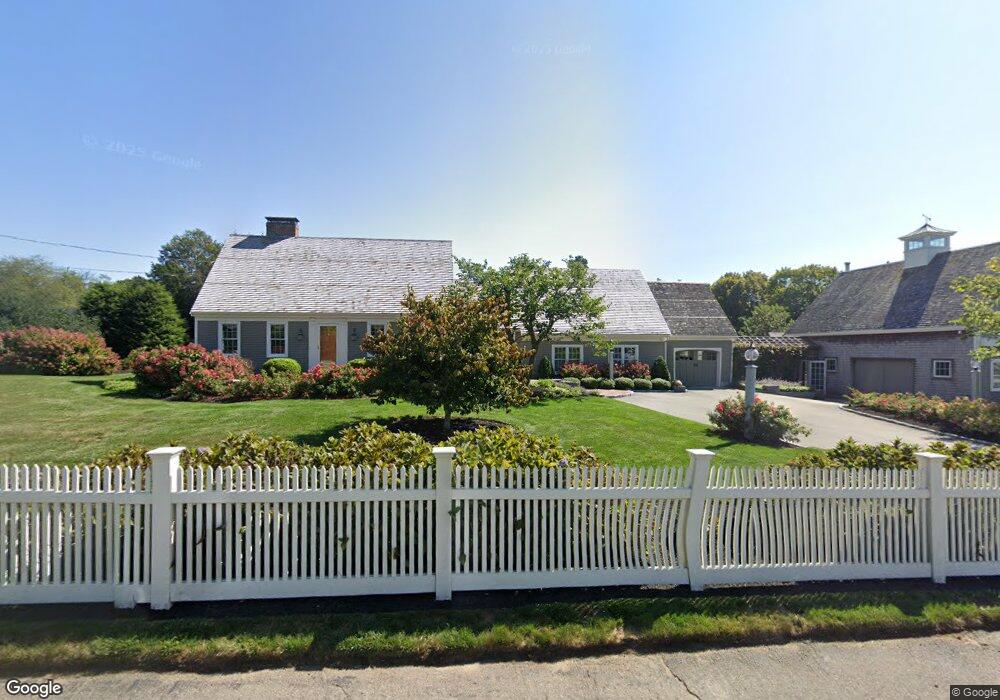
14 Cudworth Rd Scituate, MA 02066
Estimated Value: $1,341,000 - $1,482,000
4
Beds
3
Baths
3,446
Sq Ft
$416/Sq Ft
Est. Value
About This Home
This home is located at 14 Cudworth Rd, Scituate, MA 02066 and is currently estimated at $1,432,399, approximately $415 per square foot. 14 Cudworth Rd is a home located in Plymouth County with nearby schools including Cushing Elementary School, Lester J. Gates Middle School, and Scituate High School.
Ownership History
Date
Name
Owned For
Owner Type
Purchase Details
Closed on
Sep 25, 2024
Sold by
Anderson Robert C and Anderson William T
Bought by
Anderson Ft and Andeson
Current Estimated Value
Purchase Details
Closed on
Aug 25, 1980
Bought by
Anderson William and Anderson Roberta
Create a Home Valuation Report for This Property
The Home Valuation Report is an in-depth analysis detailing your home's value as well as a comparison with similar homes in the area
Home Values in the Area
Average Home Value in this Area
Purchase History
| Date | Buyer | Sale Price | Title Company |
|---|---|---|---|
| Anderson Ft | -- | None Available | |
| Anderson Ft | -- | None Available | |
| Anderson William | -- | -- |
Source: Public Records
Mortgage History
| Date | Status | Borrower | Loan Amount |
|---|---|---|---|
| Previous Owner | Anderson William | $57,500 | |
| Previous Owner | Anderson William | $60,000 |
Source: Public Records
Tax History Compared to Growth
Tax History
| Year | Tax Paid | Tax Assessment Tax Assessment Total Assessment is a certain percentage of the fair market value that is determined by local assessors to be the total taxable value of land and additions on the property. | Land | Improvement |
|---|---|---|---|---|
| 2025 | $12,000 | $1,201,200 | $400,000 | $801,200 |
| 2024 | $11,908 | $1,149,400 | $363,700 | $785,700 |
| 2023 | $11,774 | $1,057,900 | $349,000 | $708,900 |
| 2022 | $11,586 | $918,100 | $322,300 | $595,800 |
| 2021 | $4,847 | $817,400 | $306,900 | $510,500 |
| 2020 | $4,834 | $787,900 | $295,100 | $492,800 |
| 2019 | $4,623 | $719,700 | $264,700 | $455,000 |
| 2018 | $4,543 | $661,400 | $264,900 | $396,500 |
| 2017 | $8,319 | $590,400 | $253,900 | $336,500 |
| 2016 | $8,036 | $568,300 | $231,800 | $336,500 |
| 2015 | $7,301 | $557,300 | $220,800 | $336,500 |
Source: Public Records
Map
Nearby Homes
- 115 Elm St
- 111 Elm St
- 290 Beaver Dam Rd
- 18 James Way
- 13 Hornbeam Rd
- 116 Old Forge Rd
- 74 Tilden Rd
- 14 Aberdeen Dr
- 22 Kings Way
- 54 Woodland Rd
- 148 Tilden Rd
- 12 Sassamon Rd
- 76 A Brook St
- 76 A Brook St Unit 1
- 1 Hillside Rd
- 59 Captain Peirce Rd
- 2 Windward Ln
- 575 First Parish Rd
- 50 First Parish Rd
- 19 Ford Place Unit 3
- 14 Daedalus Cir
- 20 Cudworth Rd
- 284 Country Way
- 284 Country Way
- 10 Daedalus Cir
- 15 Cudworth Rd
- 144 Elm St
- 288 Central Ave Unit 288
- 286 Central Ave
- 286 Central Ave Unit 286
- 290 Central Ave Unit 1
- 19 Cudworth Rd
- 284 Central Ave
- 284 Central Ave Unit 284
- 9 Meadow Ln
- 9 Meadow Ln Unit R
- 19 Daedalus Cir
- 26 Cudworth Rd
- 285 Country Way
- 138 Elm St