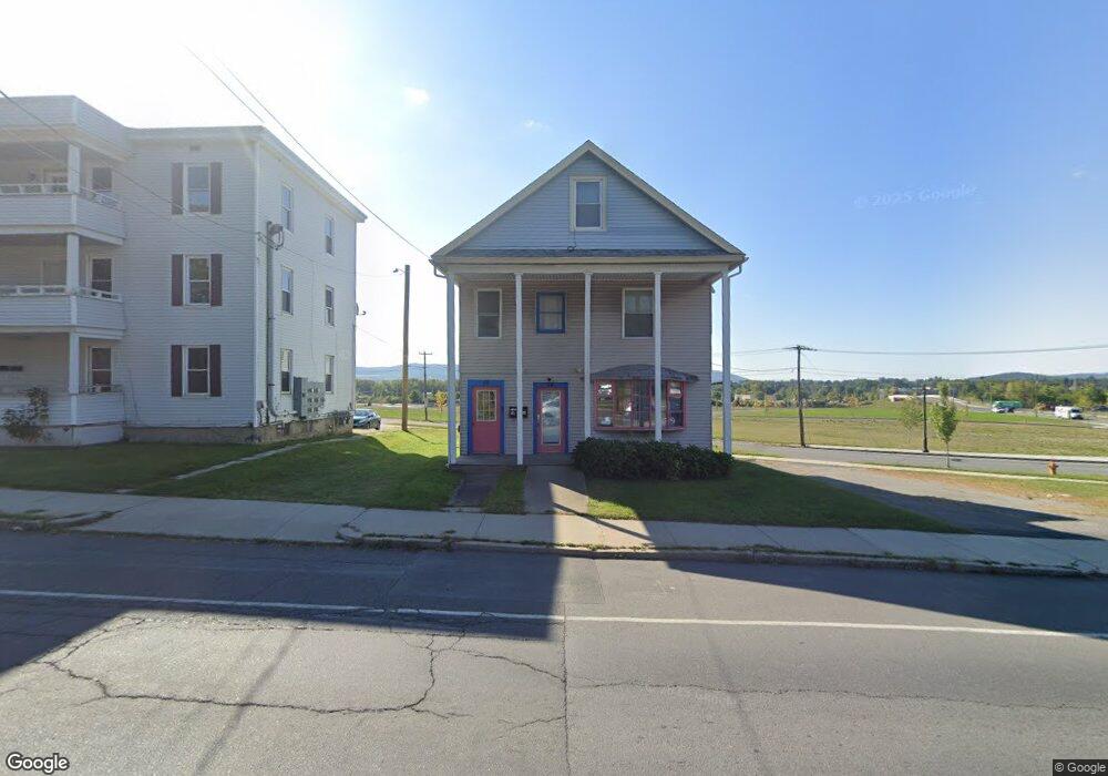
14 Dalton Ave Pittsfield, MA 01201
1
Bed
3
Baths
4,242
Sq Ft
3,920
Sq Ft Lot
About This Home
This home is located at 14 Dalton Ave, Pittsfield, MA 01201. 14 Dalton Ave is a home located in Berkshire County with nearby schools including Allendale Elementary School, Theodore Herberg Middle School, and Pittsfield High School.
Ownership History
Date
Name
Owned For
Owner Type
Purchase Details
Closed on
May 7, 2019
Sold by
Bespoke Costuming Llc
Bought by
Kathryn R Kearns Ret and Kearns
Purchase Details
Closed on
Apr 2, 2013
Sold by
Greylock Fcu
Bought by
Bespoke Costuming Llc
Purchase Details
Closed on
Apr 4, 2012
Sold by
Pierce Jeffrey D
Bought by
Greylock Fcu
Purchase Details
Closed on
May 12, 2011
Sold by
Pierce Jeffrey D
Bought by
Pittsfield City Of
Purchase Details
Closed on
Oct 5, 2000
Sold by
Sharp Nt and Martin Tara J
Bought by
Pierce Jeffrey D
Purchase Details
Closed on
May 29, 1992
Sold by
City Sav Bk Pittsfield
Bought by
Sharp Nt
Purchase Details
Closed on
Jun 19, 1991
Sold by
Vincent Keith K
Bought by
City Sb Pittsfield
Create a Home Valuation Report for This Property
The Home Valuation Report is an in-depth analysis detailing your home's value as well as a comparison with similar homes in the area
Home Values in the Area
Average Home Value in this Area
Purchase History
| Date | Buyer | Sale Price | Title Company |
|---|---|---|---|
| Kathryn R Kearns Ret | -- | -- | |
| Kathryn R Kearns Ret | -- | -- | |
| Kathryn R Kearns Ret | -- | -- | |
| Bespoke Costuming Llc | $50,000 | -- | |
| Greylock Fcu | $140,000 | -- | |
| Pittsfield City Of | -- | -- | |
| Pittsfield City Of | -- | -- | |
| Pittsfield City Of | -- | -- | |
| Pierce Jeffrey D | $71,382 | -- | |
| Pierce Jeffrey D | $71,382 | -- | |
| Sharp Nt | $70,000 | -- | |
| Sharp Nt | $70,000 | -- | |
| City Sb Pittsfield | $80,000 | -- | |
| City Sb Pittsfield | $80,000 | -- |
Source: Public Records
Mortgage History
| Date | Status | Borrower | Loan Amount |
|---|---|---|---|
| Previous Owner | City Sb Pittsfield | $89,500 | |
| Previous Owner | City Sb Pittsfield | $50,000 |
Source: Public Records
Tax History Compared to Growth
Tax History
| Year | Tax Paid | Tax Assessment Tax Assessment Total Assessment is a certain percentage of the fair market value that is determined by local assessors to be the total taxable value of land and additions on the property. | Land | Improvement |
|---|---|---|---|---|
| 2025 | -- | $134,900 | $43,600 | $91,300 |
| 2024 | -- | $116,700 | $43,600 | $73,100 |
| 2023 | $0 | $116,700 | $43,600 | $73,100 |
| 2022 | $0 | $111,200 | $43,600 | $67,600 |
| 2021 | $0 | $111,200 | $43,600 | $67,600 |
| 2020 | $3,232 | $111,200 | $43,600 | $67,600 |
| 2019 | $0 | $109,400 | $43,600 | $65,800 |
| 2018 | $3,097 | $109,400 | $43,600 | $65,800 |
| 2017 | -- | $103,100 | $43,600 | $59,500 |
| 2016 | -- | $103,100 | $43,600 | $59,500 |
| 2015 | -- | $103,100 | $43,600 | $59,500 |
Source: Public Records
Map
Nearby Homes
- LOT 20 Plunkett St
- 81 Dartmouth St Unit 205
- 81 Dartmouth St Unit 102
- 11 Stanley Ave
- 41 Perrine Ave
- 40 Roland St
- 52 Brown St
- 48 Brown St
- 24 Glenwood Ave
- 29 Glenwood Ave
- 156 Draper Ave
- 14 Allessio St
- 762 East St
- 98 Lincoln St
- 21 Huron St
- 129 Newell St
- 25 Ashley St
- 326 Dalton Ave
- 26 Springside Ave
- 68 Orchard St