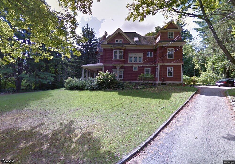
14 Estes St Amesbury, MA 01913
Estimated Value: $682,000 - $1,195,000
5
Beds
3
Baths
3,863
Sq Ft
$258/Sq Ft
Est. Value
About This Home
This home is located at 14 Estes St, Amesbury, MA 01913 and is currently estimated at $996,923, approximately $258 per square foot. 14 Estes St is a home located in Essex County with nearby schools including Amesbury High School and Amesbury Seventh-Day Adventist School.
Ownership History
Date
Name
Owned For
Owner Type
Purchase Details
Closed on
Sep 10, 2025
Sold by
Elman Victoria
Bought by
Rowan Laure B and Rowan Michael T
Current Estimated Value
Purchase Details
Closed on
Mar 7, 1997
Sold by
Willis Peter F and Holbrook-Willis Ann
Bought by
Rowan Laure B and Rowan Michael T
Purchase Details
Closed on
Aug 31, 1989
Sold by
Pesci Nello
Bought by
Willis Peter
Create a Home Valuation Report for This Property
The Home Valuation Report is an in-depth analysis detailing your home's value as well as a comparison with similar homes in the area
Home Values in the Area
Average Home Value in this Area
Purchase History
| Date | Buyer | Sale Price | Title Company |
|---|---|---|---|
| Rowan Laure B | $15,000 | -- | |
| Rowan Laure B | $15,000 | -- | |
| Rowan Laure B | $275,000 | -- | |
| Rowan Laure B | $275,000 | -- | |
| Willis Peter | $285,000 | -- | |
| Willis Peter | $285,000 | -- |
Source: Public Records
Mortgage History
| Date | Status | Borrower | Loan Amount |
|---|---|---|---|
| Previous Owner | Willis Peter | $529,728 | |
| Previous Owner | Willis Peter | $499,999 |
Source: Public Records
Tax History
| Year | Tax Paid | Tax Assessment Tax Assessment Total Assessment is a certain percentage of the fair market value that is determined by local assessors to be the total taxable value of land and additions on the property. | Land | Improvement |
|---|---|---|---|---|
| 2025 | $15,167 | $991,300 | $362,700 | $628,600 |
| 2024 | $14,322 | $915,700 | $342,000 | $573,700 |
| 2023 | $14,234 | $871,100 | $297,400 | $573,700 |
| 2022 | $14,490 | $819,100 | $258,700 | $560,400 |
| 2021 | $13,078 | $716,600 | $207,900 | $508,700 |
| 2020 | $12,480 | $726,400 | $200,000 | $526,400 |
| 2019 | $11,878 | $646,600 | $200,000 | $446,600 |
| 2018 | $11,795 | $621,100 | $190,400 | $430,700 |
| 2017 | $12,646 | $633,900 | $190,400 | $443,500 |
| 2016 | $12,079 | $595,600 | $190,400 | $405,200 |
| 2015 | $11,973 | $582,900 | $190,400 | $392,500 |
| 2014 | $12,356 | $589,200 | $190,400 | $398,800 |
Source: Public Records
Map
Nearby Homes
- 1 Hillside Ave Unit 3
- 4 Greenwood St
- 37 Lombard Ave
- 21 River St
- 47 Cutter Ln Unit 47
- 35 Orchard St
- 48 Orchard St
- 4 Clark St
- 37 Powow St
- 19 Cutter Ln Unit 19
- 97 Elm St
- 60 Merrimac St Unit 504
- 25 Cedar St Unit 7
- 382 Main St
- 101 Market St Unit B
- 105 Market St Unit B
- 204 Elm St
- 4 Spindle Tree Ln
- 149 Market St
- 21 Pond Hill Rd
- 12 Estes St
- 9 Estes St
- 67 W Greenwood St
- 10 Estes St
- 17 Estes St
- 64 W Greenwood St
- 57 W Greenwood St
- 62 W Greenwood St
- 7 Estes St
- 6A Estes St
- 60 W Greenwood St
- 6 Estes St
- 55 W Greenwood St
- 58 W Greenwood St
- 56 W Greenwood St
- 53 W Greenwood St
- 5 Estes St
- 54 W Greenwood St
- 4 Estes St
- 52 W Greenwood St
Your Personal Tour Guide
Ask me questions while you tour the home.