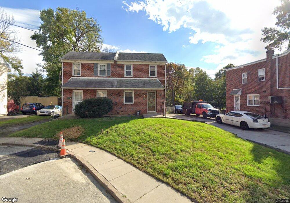
14 Florence Ave Lansdowne, PA 19050
Estimated Value: $203,000 - $224,716
3
Beds
1
Bath
1,120
Sq Ft
$194/Sq Ft
Est. Value
About This Home
This home is located at 14 Florence Ave, Lansdowne, PA 19050 and is currently estimated at $217,679, approximately $194 per square foot. 14 Florence Ave is a home located in Delaware County with nearby schools including East Lansdowne Elementary School, Penn Wood Middle School, and Penn Wood High School - Cypress Street Campus.
Ownership History
Date
Name
Owned For
Owner Type
Purchase Details
Closed on
Oct 29, 2004
Sold by
Malarkey William J and Malarkey Kathleen V
Bought by
Long Pia
Current Estimated Value
Home Financials for this Owner
Home Financials are based on the most recent Mortgage that was taken out on this home.
Original Mortgage
$118,800
Outstanding Balance
$59,364
Interest Rate
5.8%
Mortgage Type
Fannie Mae Freddie Mac
Estimated Equity
$158,315
Create a Home Valuation Report for This Property
The Home Valuation Report is an in-depth analysis detailing your home's value as well as a comparison with similar homes in the area
Home Values in the Area
Average Home Value in this Area
Purchase History
| Date | Buyer | Sale Price | Title Company |
|---|---|---|---|
| Long Pia | $120,000 | -- |
Source: Public Records
Mortgage History
| Date | Status | Borrower | Loan Amount |
|---|---|---|---|
| Open | Long Pia | $118,800 |
Source: Public Records
Tax History Compared to Growth
Tax History
| Year | Tax Paid | Tax Assessment Tax Assessment Total Assessment is a certain percentage of the fair market value that is determined by local assessors to be the total taxable value of land and additions on the property. | Land | Improvement |
|---|---|---|---|---|
| 2025 | $4,355 | $105,780 | $32,230 | $73,550 |
| 2024 | $4,355 | $105,780 | $32,230 | $73,550 |
| 2023 | $4,152 | $105,780 | $32,230 | $73,550 |
| 2022 | $4,071 | $105,780 | $32,230 | $73,550 |
| 2021 | $6,113 | $105,780 | $32,230 | $73,550 |
| 2020 | $4,271 | $65,120 | $19,620 | $45,500 |
| 2019 | $4,199 | $65,120 | $19,620 | $45,500 |
| 2018 | $4,127 | $65,120 | $0 | $0 |
| 2017 | $4,036 | $65,120 | $0 | $0 |
| 2016 | $357 | $65,120 | $0 | $0 |
| 2015 | $365 | $65,120 | $0 | $0 |
| 2014 | $357 | $65,120 | $0 | $0 |
Source: Public Records
Map
Nearby Homes
- 164 Woodland Ave
- 178 N Union Ave
- 209 E Greenwood Ave
- 315 E Essex Ave
- 317 E Essex Ave
- 319 E Essex Ave
- 88 E Essex Ave
- 239 N Maple Ave
- 226 E Greenwood Ave
- 230 Wynnewood Ave
- 75 E Stewart Ave
- 53 E Essex Ave
- 291 N Wycombe Ave
- 37 E Stratford Ave
- 243 Coverly Rd
- 32 N Wycombe Ave
- 29 W Stratford Ave
- 7229 Clinton Rd
- 7247 Guilford Rd
- 608 Pembroke Ave
- 16 Florence Ave
- 12 Florence Ave
- 18 Florence Ave
- 10 Florence Ave
- 8 Florence Ave
- 11 Florence Ave
- 172 Hansell Rd
- 9 Florence Ave
- 176 N Wycombe Ave
- 6 Florence Ave
- 174 Hansell Rd
- 170 N Wycombe Ave
- 176 Hansell Rd
- 7 Florence Ave
- 168 N Wycombe Ave
- 102 Powelton Ave
- 104 Powelton Ave
- 178 Hansell Rd
- 106 Powelton Ave
- 178 N Wycombe Ave