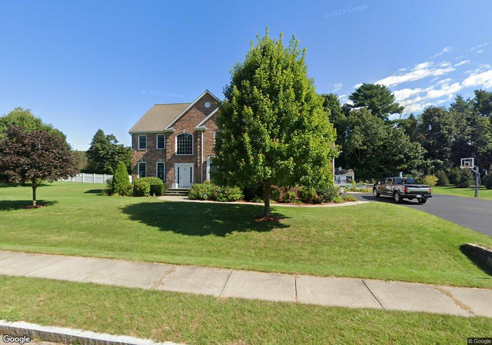
14 Gibbons Ln Wrentham, MA 02093
Estimated Value: $1,196,454 - $1,400,000
4
Beds
3
Baths
3,700
Sq Ft
$357/Sq Ft
Est. Value
About This Home
This home is located at 14 Gibbons Ln, Wrentham, MA 02093 and is currently estimated at $1,319,614, approximately $356 per square foot. 14 Gibbons Ln is a home located in Norfolk County with nearby schools including Delaney Elementary School and Charles E Roderick.
Ownership History
Date
Name
Owned For
Owner Type
Purchase Details
Closed on
Mar 31, 2008
Sold by
Bowmar Estates Llc
Bought by
Cataldo Cristina J and Sheehan William C
Current Estimated Value
Home Financials for this Owner
Home Financials are based on the most recent Mortgage that was taken out on this home.
Original Mortgage
$417,000
Outstanding Balance
$261,245
Interest Rate
5.76%
Mortgage Type
Purchase Money Mortgage
Estimated Equity
$1,058,369
Create a Home Valuation Report for This Property
The Home Valuation Report is an in-depth analysis detailing your home's value as well as a comparison with similar homes in the area
Home Values in the Area
Average Home Value in this Area
Purchase History
| Date | Buyer | Sale Price | Title Company |
|---|---|---|---|
| Cataldo Cristina J | $721,500 | -- |
Source: Public Records
Mortgage History
| Date | Status | Borrower | Loan Amount |
|---|---|---|---|
| Open | Cataldo Cristina J | $417,000 |
Source: Public Records
Tax History Compared to Growth
Tax History
| Year | Tax Paid | Tax Assessment Tax Assessment Total Assessment is a certain percentage of the fair market value that is determined by local assessors to be the total taxable value of land and additions on the property. | Land | Improvement |
|---|---|---|---|---|
| 2025 | $12,469 | $1,075,800 | $338,700 | $737,100 |
| 2024 | $11,893 | $991,100 | $338,700 | $652,400 |
| 2023 | $11,277 | $893,600 | $308,000 | $585,600 |
| 2022 | $10,723 | $784,400 | $279,800 | $504,600 |
| 2021 | $10,464 | $743,700 | $279,800 | $463,900 |
| 2020 | $10,918 | $766,200 | $230,100 | $536,100 |
| 2019 | $10,480 | $742,200 | $230,100 | $512,100 |
| 2018 | $10,290 | $722,600 | $230,200 | $492,400 |
| 2017 | $10,197 | $715,600 | $225,700 | $489,900 |
| 2016 | $10,062 | $704,600 | $219,200 | $485,400 |
| 2015 | $10,174 | $679,200 | $210,700 | $468,500 |
| 2014 | $10,020 | $654,500 | $202,700 | $451,800 |
Source: Public Records
Map
Nearby Homes
- Lot 1 - Blueberry 2 Car Plan at King Philip Estates
- Lot 8 - Blueberry 2 Car Plan at King Philip Estates
- Lot 5 - Hughes 2 car Plan at King Philip Estates
- Lot 6 - Blueberry 3 Car Plan at King Philip Estates
- Lot 2 - Camden 2 Car Plan at King Philip Estates
- Lot 7 - Cedar Plan at King Philip Estates
- Lot 4 - Hemingway 2 Car Plan at King Philip Estates
- Lot 3 - Blueberry 2 Car Plan at King Philip Estates
- Lot 3 - 14 Earle Stewart Ln
- 11 Earle Stewart Ln
- 131 Creek St Unit 7
- 791 South St Unit 5
- 319 Taunton St
- 10 Nature View Dr
- 15 Nature View Dr
- 570 Franklin St
- 440 Chestnut St
- 1204 South St
- 362 East St
- 1222 South St
- 10 Gibbons Ln
- 18 Gibbons Ln
- 7 Gibbons Ln
- 11 Gibbons Ln
- 5 Gibbons Ln
- 6 Gibbons Ln
- 4 Gibbons Ln
- 22 Gibbons Ln
- 3 Gibbons Ln
- 2 Gibbons Ln
- 15 Gibbons Ln
- LOT 2 Gibbons Ln
- 29 Village Way Unit 5
- 25 Village Way Unit 7
- 3 Village Way
- 5 Village Way
- 490 South St Unit 2
- 490 South St
- 490 South St Unit 1
- 490 South St Unit 3