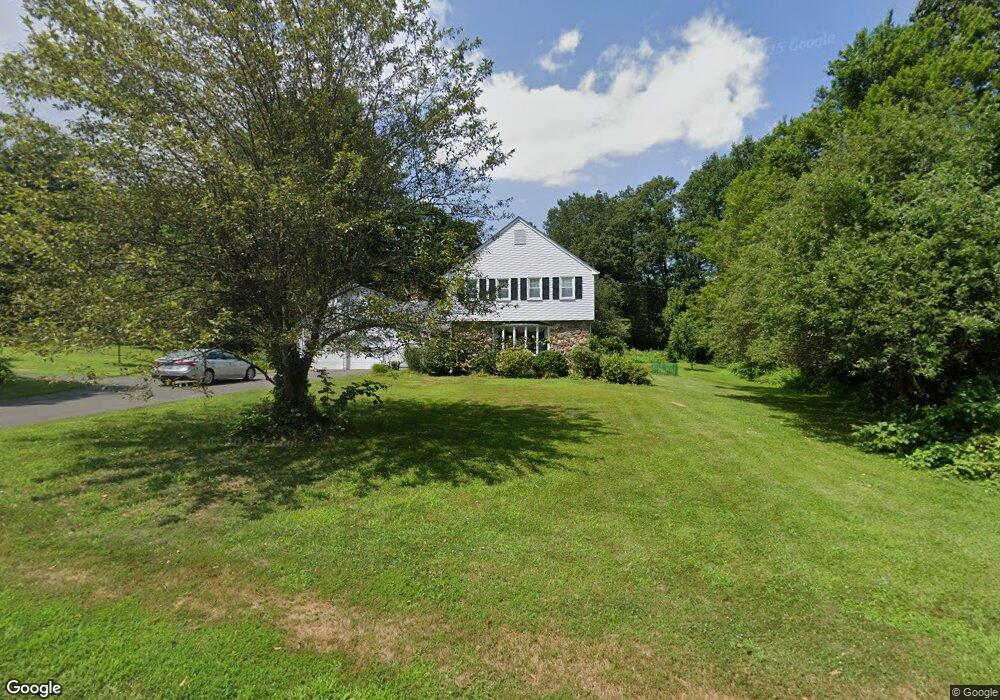
14 Homestead Rd West Simsbury, CT 06092
Estimated Value: $622,336 - $631,000
4
Beds
3
Baths
2,224
Sq Ft
$281/Sq Ft
Est. Value
About This Home
This home is located at 14 Homestead Rd, West Simsbury, CT 06092 and is currently estimated at $625,584, approximately $281 per square foot. 14 Homestead Rd is a home located in Hartford County with nearby schools including Central School, Henry James Memorial School, and Simsbury High School.
Ownership History
Date
Name
Owned For
Owner Type
Purchase Details
Closed on
Aug 4, 2006
Sold by
Stafford William E
Bought by
Healy Anthony P and Healy Carol A
Current Estimated Value
Home Financials for this Owner
Home Financials are based on the most recent Mortgage that was taken out on this home.
Original Mortgage
$334,400
Interest Rate
6.7%
Purchase Details
Closed on
May 1, 2001
Sold by
Fuge Diana S
Bought by
Emden Tobias
Purchase Details
Closed on
Mar 17, 1997
Sold by
Devince Ronald and Devince Debra
Bought by
Stafford William
Purchase Details
Closed on
Oct 7, 1994
Sold by
Kahrs Henry Est
Bought by
Devince Ronald and Devince Debra
Create a Home Valuation Report for This Property
The Home Valuation Report is an in-depth analysis detailing your home's value as well as a comparison with similar homes in the area
Home Values in the Area
Average Home Value in this Area
Purchase History
| Date | Buyer | Sale Price | Title Company |
|---|---|---|---|
| Healy Anthony P | $418,000 | -- | |
| Emden Tobias | $188,000 | -- | |
| Stafford William | $230,000 | -- | |
| Devince Ronald | $210,000 | -- |
Source: Public Records
Mortgage History
| Date | Status | Borrower | Loan Amount |
|---|---|---|---|
| Open | Devince Ronald | $323,017 | |
| Closed | Devince Ronald | $334,400 |
Source: Public Records
Tax History Compared to Growth
Tax History
| Year | Tax Paid | Tax Assessment Tax Assessment Total Assessment is a certain percentage of the fair market value that is determined by local assessors to be the total taxable value of land and additions on the property. | Land | Improvement |
|---|---|---|---|---|
| 2025 | $9,809 | $287,140 | $98,280 | $188,860 |
| 2024 | $9,565 | $287,140 | $98,280 | $188,860 |
| 2023 | $9,137 | $287,140 | $98,280 | $188,860 |
| 2022 | $9,252 | $239,510 | $99,660 | $139,850 |
| 2021 | $9,252 | $239,510 | $99,660 | $139,850 |
| 2020 | $8,883 | $239,510 | $99,660 | $139,850 |
| 2019 | $8,939 | $239,510 | $99,660 | $139,850 |
| 2018 | $9,003 | $239,510 | $99,660 | $139,850 |
| 2017 | $8,617 | $222,310 | $97,280 | $125,030 |
| 2016 | $8,252 | $222,310 | $97,280 | $125,030 |
| 2015 | $8,252 | $222,310 | $97,280 | $125,030 |
| 2014 | $8,257 | $222,310 | $97,280 | $125,030 |
Source: Public Records
Map
Nearby Homes
- 18 Meadowlark Rd
- 10 Sachems Trail
- 16 Stratton Forest Way
- 8 Quorn Hunt Rd
- 40 Firetown Rd Unit 39
- 141 Firetown Rd
- 143 N Mountain Rd
- 3 Stebbins Brook Ln
- 4 Stebbins Brook Ln
- 301 Bushy Hill Rd
- 21 Christmas Tree Hill
- 1 West St Unit 206
- 48 Library Ln Unit 48
- 247 Old Farms Rd
- 25 Barry Ln
- 23 Red Fox Run
- 15 Sand Hill Rd
- 15 Red Fox Run
- 324 Firetown Rd
- 269 W Mountain Rd