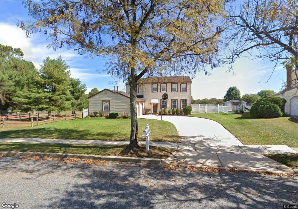
14 Langley Dr Sewell, NJ 08080
Washington Township NeighborhoodEstimated Value: $441,000 - $471,000
--
Bed
--
Bath
1,908
Sq Ft
$238/Sq Ft
Est. Value
About This Home
This home is located at 14 Langley Dr, Sewell, NJ 08080 and is currently estimated at $454,621, approximately $238 per square foot. 14 Langley Dr is a home located in Gloucester County with nearby schools including Washington Township High School, Hurffville Elementary School, and Chestnut Ridge Midle School.
Ownership History
Date
Name
Owned For
Owner Type
Purchase Details
Closed on
May 28, 2003
Sold by
Kelly Vincent F and Kelly Renee L
Bought by
Saggese Noreen N
Current Estimated Value
Home Financials for this Owner
Home Financials are based on the most recent Mortgage that was taken out on this home.
Original Mortgage
$65,000
Outstanding Balance
$28,638
Interest Rate
5.86%
Mortgage Type
Purchase Money Mortgage
Estimated Equity
$425,983
Purchase Details
Closed on
Nov 22, 2000
Sold by
Ren Tung and Lan Lee Ren I
Bought by
Kelly Vincent F and Kelly Renee L
Home Financials for this Owner
Home Financials are based on the most recent Mortgage that was taken out on this home.
Original Mortgage
$165,200
Interest Rate
7.78%
Mortgage Type
VA
Create a Home Valuation Report for This Property
The Home Valuation Report is an in-depth analysis detailing your home's value as well as a comparison with similar homes in the area
Home Values in the Area
Average Home Value in this Area
Purchase History
| Date | Buyer | Sale Price | Title Company |
|---|---|---|---|
| Saggese Noreen N | $215,000 | Independence Abstract & Titl | |
| Kelly Vincent F | $162,000 | -- |
Source: Public Records
Mortgage History
| Date | Status | Borrower | Loan Amount |
|---|---|---|---|
| Open | Saggese Noreen N | $65,000 | |
| Previous Owner | Kelly Vincent F | $165,200 |
Source: Public Records
Tax History Compared to Growth
Tax History
| Year | Tax Paid | Tax Assessment Tax Assessment Total Assessment is a certain percentage of the fair market value that is determined by local assessors to be the total taxable value of land and additions on the property. | Land | Improvement |
|---|---|---|---|---|
| 2025 | $8,123 | $219,600 | $53,900 | $165,700 |
| 2024 | $7,895 | $219,600 | $53,900 | $165,700 |
| 2023 | $7,895 | $219,600 | $53,900 | $165,700 |
| 2022 | $7,635 | $219,600 | $53,900 | $165,700 |
| 2021 | $5,049 | $219,600 | $53,900 | $165,700 |
| 2020 | $7,425 | $219,600 | $53,900 | $165,700 |
| 2019 | $7,243 | $198,700 | $38,900 | $159,800 |
| 2018 | $7,161 | $198,700 | $38,900 | $159,800 |
| 2017 | $7,072 | $198,700 | $38,900 | $159,800 |
| 2016 | $7,030 | $198,700 | $38,900 | $159,800 |
| 2015 | $6,931 | $198,700 | $38,900 | $159,800 |
| 2014 | $6,712 | $198,700 | $38,900 | $159,800 |
Source: Public Records
Map
Nearby Homes
- 117 Shire Dr
- 224 Hurffville Grenloch Rd
- 8 Elk Ct
- 78 Abbington Ln
- 122, 124 & 126 Salina Rd
- 38 Freedom Rd
- 11 Pony Run
- 155 Covered Bridge Ct
- 3 Drake Terrace
- 109 Covered Bridge Ct Unit 109
- 11 Samantha Ct
- 606 Hurffville Crosskeys Rd
- 137 Meridian Ln
- 602 Hurffville Crosskeys Rd
- 111 Belfry Place
- 213 Hurffville Rd
- 109 Lambs Rd
- 213 Boothby Ct Unit 213
- 63 Cranford Rd
- 536 Delsea Dr