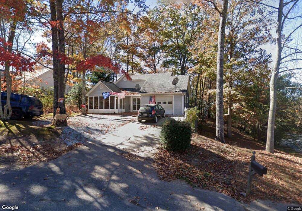
14 Laurelwood Ln Blue Ridge, GA 30513
Estimated Value: $297,850 - $599,000
--
Bed
--
Bath
1,290
Sq Ft
$333/Sq Ft
Est. Value
About This Home
This home is located at 14 Laurelwood Ln, Blue Ridge, GA 30513 and is currently estimated at $429,213, approximately $332 per square foot. 14 Laurelwood Ln is a home with nearby schools including Fannin County High School and Fannin Christian Learning Center.
Ownership History
Date
Name
Owned For
Owner Type
Purchase Details
Closed on
Sep 28, 2011
Sold by
Arp Angie Mae
Bought by
Blue Ridge Rental Properties Llc
Current Estimated Value
Purchase Details
Closed on
Mar 24, 2000
Sold by
Little G William
Bought by
Arp Angie Mae
Purchase Details
Closed on
Nov 3, 1999
Sold by
Arp Richard
Bought by
Arp Angie Mae
Purchase Details
Closed on
Dec 20, 1995
Sold by
N G M C C R C Inc
Bought by
Arp Richard
Purchase Details
Closed on
Oct 19, 1994
Sold by
Thomas Martha Q
Bought by
N G M C C R C Inc
Purchase Details
Closed on
Jan 21, 1994
Sold by
Thomas Martha O
Bought by
Thomas Martha Q
Create a Home Valuation Report for This Property
The Home Valuation Report is an in-depth analysis detailing your home's value as well as a comparison with similar homes in the area
Home Values in the Area
Average Home Value in this Area
Purchase History
| Date | Buyer | Sale Price | Title Company |
|---|---|---|---|
| Blue Ridge Rental Properties Llc | -- | -- | |
| Arp Angie Mae | -- | -- | |
| Arp Angie Mae | -- | -- | |
| Arp Richard | $174,500 | -- | |
| N G M C C R C Inc | $70,700 | -- | |
| Thomas Martha Q | -- | -- |
Source: Public Records
Tax History Compared to Growth
Tax History
| Year | Tax Paid | Tax Assessment Tax Assessment Total Assessment is a certain percentage of the fair market value that is determined by local assessors to be the total taxable value of land and additions on the property. | Land | Improvement |
|---|---|---|---|---|
| 2024 | $926 | $100,990 | $9,040 | $91,950 |
| 2023 | $848 | $83,214 | $9,040 | $74,174 |
| 2022 | $859 | $84,260 | $9,040 | $75,220 |
| 2021 | $706 | $50,319 | $9,040 | $41,279 |
| 2020 | $717 | $50,319 | $9,040 | $41,279 |
| 2019 | $731 | $50,319 | $9,040 | $41,279 |
| 2018 | $1,015 | $65,888 | $26,000 | $39,888 |
| 2017 | $794 | $44,880 | $4,480 | $40,400 |
| 2016 | $545 | $32,083 | $4,480 | $27,603 |
| 2015 | $576 | $32,446 | $4,480 | $27,966 |
| 2014 | $650 | $36,866 | $4,480 | $32,386 |
| 2013 | -- | $29,856 | $4,480 | $25,376 |
Source: Public Records
Map
Nearby Homes
- Lot 11 Lindsey Ln
- Unit 14 Chapel Dr Unit 14
- Unit 1 Chapel Dr Unit 1
- Unit 7 Grove Loop
- Unit 19 Grove Loop
- Unit 18 Grove Loop
- Unit 51 Grove Loop
- Unit 31 Grove Loop
- Unit 16 Grove Loop
- Unit 14 Grove Loop
- Unit 47 Grove Loop
- Unit 33 Grove Loop Unit 33
- Unit 33 Grove Loop
- Unit 38 Grove Loop
- Unit 1 Grove Loop
- Unit 27 Grove Loop
- Unit 15 Grove Loop
- Unit 32 Grove Loop
- 4 Blackhawk Dr
- 2 Blackhawk Dr
- 30 Laurelwood Ln
- 30 Laurelwood Ln Unit 37
- 25 Brookwood Ct
- 117 Riverwood Dr
- 17 Laurelwood Ln
- 19 Laurelwood Ln
- 115 Riverwood Dr
- 57 Laurelwood Dr
- 6 Brookwood Ct
- 8 Brookwood Ct
- 157 Riverwood Dr
- 155 Riverwood Dr
- 65 70 Cherry Wood Ct
- 164 Riverwood Dr
- 103 Riverwood Dr
- 101 Riverwood Dr
- 25 Laurelwood Ln
- 25 Laurelwood Ln
- 5 Brookwood Ct
- 173 Riverwood Dr