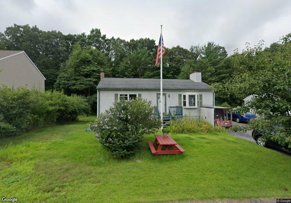
14 Robin Dr Douglas, MA 01516
Estimated Value: $339,000 - $360,626
2
Beds
1
Bath
1,296
Sq Ft
$272/Sq Ft
Est. Value
About This Home
This home is located at 14 Robin Dr, Douglas, MA 01516 and is currently estimated at $352,907, approximately $272 per square foot. 14 Robin Dr is a home located in Worcester County with nearby schools including Douglas Primary School, Douglas Middle School, and Douglas High School.
Ownership History
Date
Name
Owned For
Owner Type
Purchase Details
Closed on
Aug 25, 2004
Sold by
Brendon Prop Two Rt
Bought by
Ayou Michele L and Ayou Said
Current Estimated Value
Home Financials for this Owner
Home Financials are based on the most recent Mortgage that was taken out on this home.
Original Mortgage
$579,900
Outstanding Balance
$289,976
Interest Rate
6.02%
Mortgage Type
Purchase Money Mortgage
Estimated Equity
$62,931
Purchase Details
Closed on
Jul 18, 1995
Sold by
Baltic Rlty Corp
Bought by
Guertin Dennis and Guertin Mary E
Create a Home Valuation Report for This Property
The Home Valuation Report is an in-depth analysis detailing your home's value as well as a comparison with similar homes in the area
Home Values in the Area
Average Home Value in this Area
Purchase History
| Date | Buyer | Sale Price | Title Company |
|---|---|---|---|
| Ayou Michele L | $724,900 | -- | |
| Guertin Dennis | $94,775 | -- |
Source: Public Records
Mortgage History
| Date | Status | Borrower | Loan Amount |
|---|---|---|---|
| Open | Ayou Michele L | $579,900 | |
| Previous Owner | Guertin Dennis | $122,600 | |
| Previous Owner | Guertin Dennis | $106,500 | |
| Previous Owner | Guertin Dennis | $92,000 |
Source: Public Records
Tax History
| Year | Tax Paid | Tax Assessment Tax Assessment Total Assessment is a certain percentage of the fair market value that is determined by local assessors to be the total taxable value of land and additions on the property. | Land | Improvement |
|---|---|---|---|---|
| 2025 | $3,372 | $256,000 | $0 | $256,000 |
| 2024 | $3,076 | $227,500 | $0 | $227,500 |
| 2023 | $3,166 | $220,500 | $0 | $220,500 |
| 2022 | $3,351 | $205,100 | $0 | $205,100 |
| 2021 | $2,739 | $163,800 | $0 | $163,800 |
| 2020 | $2,768 | $163,000 | $0 | $163,000 |
| 2019 | $2,875 | $164,300 | $0 | $164,300 |
| 2018 | $2,449 | $152,400 | $0 | $152,400 |
| 2017 | $2,261 | $135,200 | $0 | $135,200 |
| 2016 | $2,200 | $130,800 | $0 | $130,800 |
| 2015 | $2,153 | $130,800 | $0 | $130,800 |
Source: Public Records
Map
Nearby Homes
- 41 Martin Rd
- 5 B St
- 99 Maple St
- 3 S East Main St
- 2 White Ct
- 408 NE Main St
- 22 Gilboa St
- 10 Essex St
- 11 Old Farm Rd
- 153 Davis St
- 26 Compass Point Dr Unit 26
- 296 Yew St
- 36 Compass Point Dr Unit 36
- 59 Old Farm Rd
- 33 Nautical Way Unit 107
- 108 Mumford St
- 1 White Ct
- 48 Walnut St
- Lot 27 Cedar St
- 19 Birch St
Your Personal Tour Guide
Ask me questions while you tour the home.