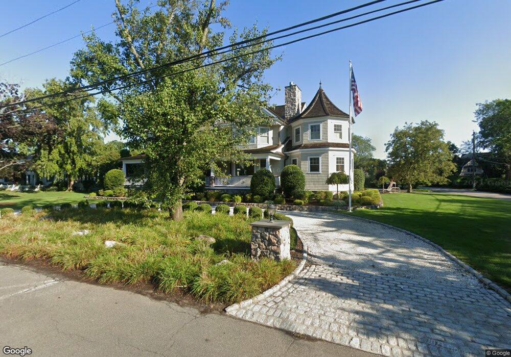
14 Shipway Rd Darien, CT 06820
Estimated Value: $3,779,000 - $7,528,000
6
Beds
7
Baths
7,981
Sq Ft
$704/Sq Ft
Est. Value
About This Home
This home is located at 14 Shipway Rd, Darien, CT 06820 and is currently estimated at $5,620,039, approximately $704 per square foot. 14 Shipway Rd is a home located in Fairfield County with nearby schools including Hindley Elementary School, Middlesex Middle School, and Darien High School.
Ownership History
Date
Name
Owned For
Owner Type
Purchase Details
Closed on
Apr 25, 2019
Sold by
Jones Craig and Jones Cassandra
Bought by
Baywatch Partners Llc
Current Estimated Value
Purchase Details
Closed on
Aug 8, 2013
Sold by
Snow-Arbron Erica
Bought by
Branca Nicholas N and Branca Stacia E
Purchase Details
Closed on
Jul 1, 2005
Sold by
Jennings Lee M
Bought by
Branca Nicholas and Branca Stacia
Home Financials for this Owner
Home Financials are based on the most recent Mortgage that was taken out on this home.
Original Mortgage
$1,755,000
Interest Rate
4.75%
Purchase Details
Closed on
Feb 27, 2004
Sold by
Raffaek Patrick M and Raffaele Winifred A
Bought by
Jennings William B and Jennings Lee M
Create a Home Valuation Report for This Property
The Home Valuation Report is an in-depth analysis detailing your home's value as well as a comparison with similar homes in the area
Home Values in the Area
Average Home Value in this Area
Purchase History
| Date | Buyer | Sale Price | Title Company |
|---|---|---|---|
| Baywatch Partners Llc | $1,275,000 | -- | |
| Branca Nicholas N | $2,850,000 | -- | |
| Branca Nicholas | $3,000,000 | -- | |
| Jennings William B | $1,860,000 | -- |
Source: Public Records
Mortgage History
| Date | Status | Borrower | Loan Amount |
|---|---|---|---|
| Previous Owner | Jennings William B | $700,000 | |
| Previous Owner | Jennings William B | $1,755,000 | |
| Previous Owner | Jennings William B | $1,493,000 |
Source: Public Records
Tax History Compared to Growth
Tax History
| Year | Tax Paid | Tax Assessment Tax Assessment Total Assessment is a certain percentage of the fair market value that is determined by local assessors to be the total taxable value of land and additions on the property. | Land | Improvement |
|---|---|---|---|---|
| 2025 | $62,615 | $4,044,880 | $1,666,000 | $2,378,880 |
| 2024 | $59,419 | $4,044,880 | $1,666,000 | $2,378,880 |
| 2023 | $59,851 | $3,398,710 | $1,190,000 | $2,208,710 |
| 2022 | $58,560 | $3,398,710 | $1,190,000 | $2,208,710 |
| 2021 | $6,708 | $3,398,710 | $1,190,000 | $2,208,710 |
| 2020 | $6,827 | $3,398,710 | $1,190,000 | $2,208,710 |
| 2019 | $55,977 | $3,398,710 | $1,190,000 | $2,208,710 |
| 2018 | $55,752 | $3,467,170 | $1,190,000 | $2,277,170 |
| 2017 | $6,763 | $3,467,170 | $1,190,000 | $2,277,170 |
| 2016 | $54,677 | $3,467,170 | $1,190,000 | $2,277,170 |
| 2015 | $53,221 | $3,467,170 | $1,190,000 | $2,277,170 |
| 2014 | $52,042 | $3,467,170 | $1,190,000 | $2,277,170 |
Source: Public Records
Map
Nearby Homes
- 5 Shipway Rd
- 5 Mayflower Rd
- 92 Pear Tree Point Rd
- 88 Pear Tree Point Rd
- 28 Aquila Rd
- 33 Dora St
- 3 Dean St Unit B2
- 16 Neponsit St
- 120 Webb Ave
- 214 Seaside Ave
- 214 Seaside Ave Unit 2
- 55 Avery St
- 53 Noroton Ave
- 209 Seaside Ave Unit 2
- 86 Wallacks Dr
- 105 Houston Terrace
- 15 Robin St
- 114 Sylvan Knoll Rd
- 737 Cove Rd Unit D2
- 171 Sylvan Knoll Rd